Showing posts with label Vacation 2023. Show all posts

Saturday, July 29, 2023

Two Weeks on Salt Water - End of Another Great Vacation

Yesterday on Wickford Harbor
Our annual summer vacation in South County ends today, so we are packing up and heading home. Now that I have a sea kayak, this is the first year that I didn’t bring my solo canoe. To be honest, I didn’t miss it. The sea kayak made it much easier to deal with the wind and waves in this coastal environment – right boat for the job. I did bring my tandem canoe, so Michelle and I paddled down to the Beach at the Narrows. I spent a lot of time paddling on Point Judith Pond, including my annual RICKA trip. I also got out to a few old favorites – Narrow River, Jamestown Harbor, Dutch Harbor, the Harbor of Refuge and Wickford. It is windy and rainy with rumbles of thunder this morning, so I’m done paddling for this vacation.

South County Vacation 2023 from Erik Eckilson on Vimeo.

Friday, July 28, 2023

Wickford Harbor - July 28, 2023

The Castle
It was my last full day at the cottage, so I decided to head out to paddle at Wickford Harbor. With last night’s storm it would be sheltered form the wind, and I’d be able to check out the North Kingstown Town Beach for the RICKA Picnic.

Wickford was established in the early 17th century when Roger Williams purchased land from the Narragansett Indians and established a trading post. In 1637, Williams sold the land to Richard Smith who constructed a large fortified house on the site, giving the house its nickname the “Castle”. That house was burned during King Philip's War, and the structure that can be seen from the put-in today was built in 1678.

Wickford Shipyard
Wickford grew to become a major port and shipbuilding center, and today contains a large collection of 17th and 18th century homes. It is a picturesque village whose streets are lined with shops and restaurants, and whose harbor is filled with sailboats and yachts.

I headed out from Wilson Park into Wickford Harbor and paddled out past the breakwater into the surprisingly calm waters of Narragansett Bay. It’s just a short paddle over to the North Kingstown Town Beach. There were a couple of kayak fishermen outside of the breakwater, but otherwise I had the harbor to myself.

Sailboats in Narragansett Bay
Links:

Thursday, July 27, 2023

Point Judith Pond with RICKA - July 26, 2023

Paul heading out from Marina Park
I had to reschedule Sunday’s Point Judith trip due to family obligations. We decided to do a mid-week trip on Wednesday. The forecast was for a hot day with winds from the south. We had 6 boats – all kayaks.

Point Judith Pond, or the Great Salt Pond, is located along the border of Narragansett and South Kingstown, and is the second largest of the Rhode Island’s South County salt ponds. It is a shallow, four-mile long pond located behind the barrier beaches and sand dunes that form Point Judith. The pond is 20 miles around with many pretty islands and coves to explore.

Lunch at the beach
The weather was hot with a slight breeze as we met at the town boat ramp at Marina Park. We headed out into the Upper Pond, paddled through the Narrows and out into Point Judith Pond. We explored the coves on the west side of the pond on the way to Gardner Island where we crossed the boat channel. We paddled across the top of Great Island and stopped at the cottage for a picture before heading down the east side of Great Island into Galilee to avoid the wind.

We paddled across the top of Galilee and crossed back over the boat channel near Snug Harbor to have lunch at the beach in Jerusalem. Since the wind was blowing from the south we crossed the boat channel again returned up the west side of Great Island. With the wind to our backs, the return trip went much faster. Eight miles total – everyone did great.

Links:

Monday, July 24, 2023

Harbor of Refuge - July 24, 2023

Point Judith Light
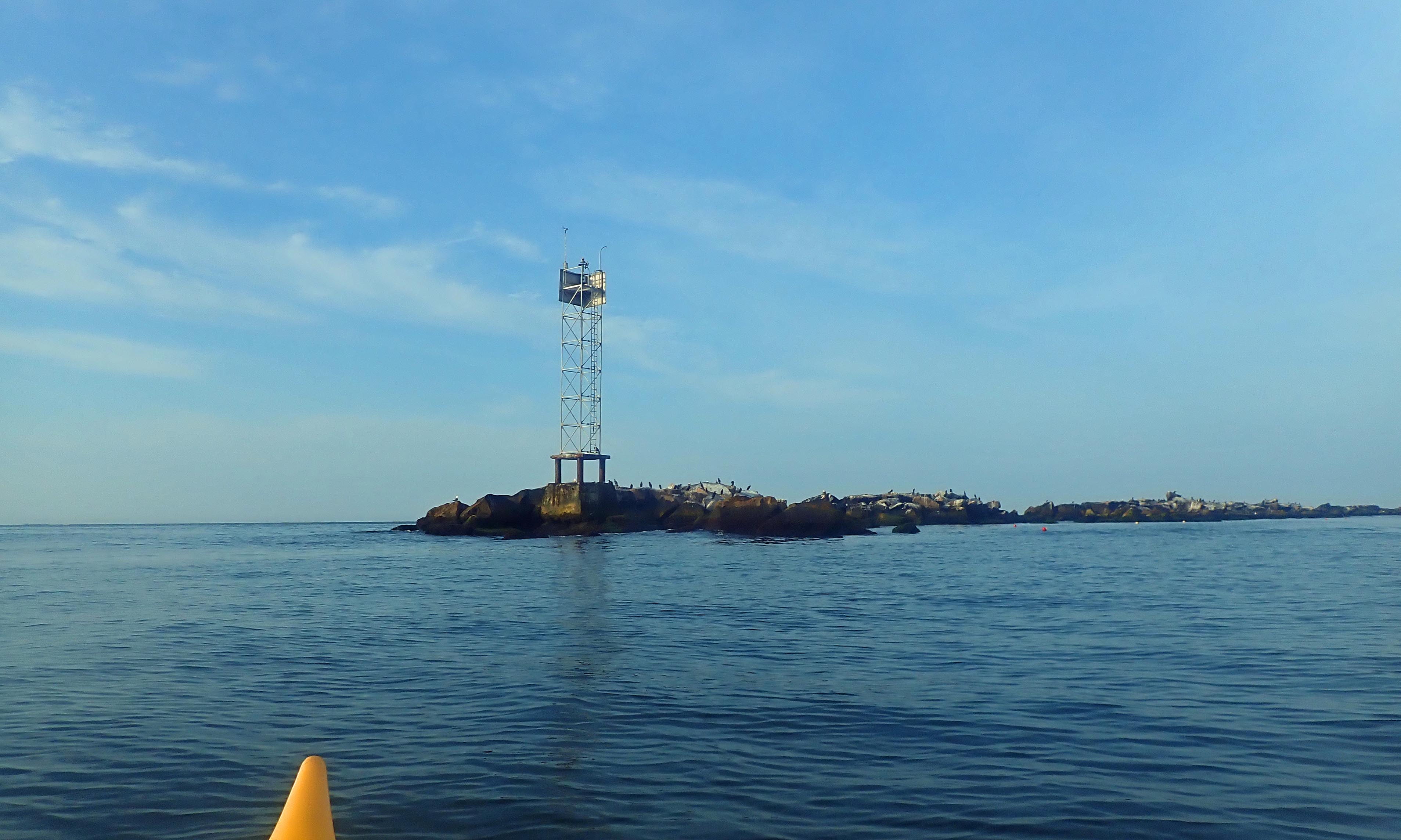
I was up early and the wind and water were calm, so I headed over to Camp Cronin to paddle inside the breakwater at the Harbor of Refuge.

Even after construction of the Point Judith Light (c. 1810/1857) conditions remained treacherous at the tip of Point Judith and a Federal project was initiated to construct over 3-miles of jetties to provide a secure breakwater refuge for shipping. Work began in 1890 with construction of the east (3,640 feet) and west (2,240 feet) jetties, and was completed in 1910 with construction the V-shaped center jetty (6,970 feet). A 1,500-foot opening was left for the east passage, and a 1,200-foot opening was left for the west passage.

Across the east passage
While the jetties were originally constructed to provide a refuge for ships traveling between Boston and New York during bad weather, they also protected the newly constructed Port of Galilee. In 1910, the Town of South Kingstown and the State of Rhode Island dredged the current Breachway and stabilized it with stone jetties. Then, in the 1930's, the State of Rhode Island dredged an anchorage basin just inside the Breachway and built wharves to create a port for large, ocean-going fishing vessels. This allowed the Galilee to become one of the largest fishing ports on the east coast

During World War II, much of the land on Point Judith was part of Fort Greene - named for Revolutionary war hero Nathanael Greene. Huge sixteen inch guns were located in the area now known as Fisherman's Memorial State Park to protect the west side of Narragansett Bay. Smaller fortifications were located along the shoreline. Fort Greene was part of a network of forts protecting Narragansett Bay including Fort Adams in Newport, Fort Greble on Dutch Island, Fort Weatherill in Jamestown, and Fort Hamilton on Rose Island.

Birds on the breakwater
There were just a couple fishermen on the breakwater, and a couple of boats heading out the east passage. The sea was relatively calm behind the breakwater with small wind-blown waves, but I crossed the east passage in 1-2 foot rolling waves. I usually I do the loop up the east jetty, down the west jetty and across the beach - about 4-miles. Today I did an up and back along the east jetty - about 2.5 miles.

The east side of the center jetty is in much worse condition than the west, which has been rebuilt. Huge boulders have been pushed aside leaving large gaps in the seawall. It's hard to imagine that water can move those huge rocks. I paddled by the cormorants and other shore birds resting on the seawall out to the tip of the "V" in the center jetty before heading back.


Break at the top of the breakwater
Links:

Sunday, July 23, 2023

Dutch Island - July 23, 2023

Jamestown Bridge from Dutch Harbor
It was a beautiful morning, so I decide to head over to Dutch Harbor to paddle out to the Dutch Island Light. The bay was calm, winds were light and conditions were perfect.

Dutch Island is located in the West Passage of Narragansett Bay and took its name from the Dutch East India Company that established a trading post here around 1636. After the Revolutionary War the island was fortified to protect the West Passage from invasion by sea. In the 1890’s the Army established Fort Greble here. Like Fort Weatherill on the East Passage, Fort Greble was active through World War II and was part of a series of heavily fortified artillery placements that protected Narragansett Bay.

Dutch Island Light
The first lighthouse was completed on the southern tip of Dutch Island in 1826. The original tower was replaced with the current tower in 1857. The lighthouse remained in service until 1979 when it was replaced with a flashing buoy. It then fell into disrepair until 2007 when it was restored by the Dutch Island Lighthouse Society.

I put in at Dutch Harbor and paddled out toward the Dutch Island Light. After snapping a few pictures, I continued around the west side of island before retuning to the take out.

Newport Bridge
Links:

Saturday, July 22, 2023

Jamestown Harbor - July 22, 2023

Newport Bridge
I decided to head over to Jamestown this morning to paddle around Jamestown Harbor and get some pictures of the Newport Bridge. I put in at the East Ferry Boat Ramp and headed out into the harbor.

The Newport Bridge was completed in 1969 and is the longest suspension bridge in New England. It spans the East Passage of Narragansett Bay from Jamestown to Newport. The main span is over 1,600 feet long, and the road deck is more 200 feet above the water. The towers themselves are over 400 feet tall.

Clingstone
I followed the boat moorings down to the Dumplings - a grouping of rocks just off Bull Point. The most prominent of the Dumplings is Clingstone or the "House on the Rock". This massive post and beam home was built in 1905 and has been recently restored.

It turned out to be a nice morning with the tide going out and 1 to 2 rolling waves - great conditions for the trip.


Newport Bridge and the Dumplings
Links:

Friday, July 21, 2023

The Coves on Point Judith Pond - July 21, 2023

Smelt Brook Cove
I slept a little late this morning, and with the kids coming down today, I was back out for a paddle on Point Judith Pond. It was a bright, clear morning with just a touch of wind, so why not. This time I padded up to the coves in the northeast corner of the pond - Turner Cove, Smelt Brook Cove and Cogdon Cove - and around Commock Island before heading back. Birds everywhere - seagulls, egrets, cormorants and osprey.

Hidden cottage on Cogdon Cove

Wednesday, July 19, 2023

The Beach at the Narrow River - July 19, 2023

Our view of the waves
I was back on the Narrow River this afternoon to paddle with Michelle down to the beach at the Narrows at Cormorant Point.

We put in at the Sprague Bridge on Boston Neck Road at the John H Chafee National Wildlife Refuge. Established in 1973, the refuge includes over 300-acres of saltmarsh around Pettaquamscutt Cove that provides habitat for shore birds like egrets, herons, cormorants and osprey.

Cormorant Point
We headed the other way through the Narrows down to the beach. As always, the shore was lined with motor and paddle boats, but there were very few people on the beach itself. We sat on the ocean side to enjoy the waves at Cormorant Point and down the beach to the Dunes Club and the Narragansett Town Beach.

The trip back was a little tricky with the out-going tide, but we managed just fine.


Ready to head back
Links:

Upper Narrow River - July 19, 2023

Paddling through the Narrows
After three days of paddling on Point Judith Pond, I was looking for something different. It needed to be someplace that wouldn’t have too many waves, so I decided to paddle the upper section of the Narrow River.

The Narrow River, also known at the Pettaquamscutt River, is the tidal extension of the Mattatuxet River. It begins below the Carr Pond Dam at the Gilbert Stuart Birthplace and flows south for 6-miles forming the border between South Kingstown and Narragansett before entering Pettaquamscutt Cove and then flowing out into Narragansett Bay above the Narragansett Town Beach and the Dunes Club.

The bridge at Bridgetown Road
There are five distinct sections of the Narrow River – the Upper Pond, the Lower Pond, the “Narrows” from Bridgetown Road and Middlebridge Road, the “Flats” at Pettaquamscutt Cove, and the “Narrows” at the mouth of the river where it flows into Narragansett Bay.

I put in at the Narrow River Fishing Area off Pollock Avenue and paddled upstream into the “Narrows” between Bridgetown Road and Middlebridge Road. This section of the river is lined with boat docks and summer houses.

Casey's Sill between Upper and Lower Ponds
Above Bridgetown Road, I paddled through the Lower Pond, and then the Upper Pond before paddling up a short section of the river that leads to the Gilbert Stuart Birthplace. It was too shallow for me to go up very far, so I turned around had headed back downstream.

Nice trip, and even with a strong wind it was easy to do in my sea kayak.

View up the Lower Pond from the Bridgetown Road Bridge
Links:

Tuesday, July 18, 2023

Upper Point Judith Pond - July 18, 2023

Egrets at Ram Island
It was another foggy morning, so I stayed close to the cottage and paddled to Upper Point Judith Pond. I'll be leading a RICKA trip from there next week.

Unlike Rhode Island’s other large salt ponds (Ninigret, Green Hill, Quonochontaug and Winnapaug) that are coastal lagoons, Point Judith Pond is an estuary where the Saugatucket River empties to the sea. I paddled up past Ram Island and Harbor Island, through the Narrows into the Upper Pond, and into the Saugatucket River at Silver Spring Cove. Lots of birds out this morning.

Osprey about to fly off near Silver Spring Cove
Links:

Port of Galilee - July 17, 2023

Snug Harbor Light
With pea soup fog I didn’t get many pictures this morning, so I put my boat in the water this afternoon and padded down to Galilee. I headed south into a moderate headwind down the west side of Great Island past Thomas Point, Little Comfort, Snug Harbor and into the Port of Galilee. It was easy in my sea kayak.

The Port of Galilee was created in 1935 when a harbor was dredged and a dock constructed at the mouth of Point Judith Pond. Connected to the ocean by the Breakaway and the Harbor of Refuge, both completed in 1910, Galilee eventually became the home port for much of Rhode Island's fishing industry. I paddled down to the mouth of the Breachway on the Jerusalem side, and back up past the fishing trawlers, lobster boats and charter boats on the Galilee side before returning to the cottage up the east side of Great Island. 

At the mouth of the Breachway
Links:

Around the Islands in Point Judith Pond - July 17, 2023

Cormorants at the oyster farm
It was foggy morning, so I decided to stay close to home and paddle around the islands in the middle of Point Judith Pond.
Point Judith Pond has three large islands – Great Island, Harbor Island and Ram Island – and four smaller islands - Jonathan Island, Beach Island, Gardner Island and Plato Island. Ram Island is posted no trespassing. Great Island, Harbor Island, Jonathan Island and Plato Island have houses on them. Gardner Island or Beach Island are the best places to stop for lunch.

Egrets were foraging on the banks of Jonathan Island and Ram Island. I crossed over at Beach and Gardner Islands, and paddled up the west side of the Point Judith Pond past the oyster farms before crossing over to Pine Tree Point and heading back to the cottage. With the fog it was tough to get any good pictures.

View down Point Judith Pond
Links:

Sunday, July 16, 2023

Around Great Island - July 16, 2023

Our cottage on Horseshoe Point
On one of the paddling message boards that I follow, I am constantly telling people to get the right boat for the conditions. This morning I did just that. It was the first morning of my summer vacation at Point Judith Pond, and I went out for the traditional paddle around Great Island. A strong wind was blowing from the southwest. It would have been a slog in my canoe, but in my sea kayak it was easy.

Point Judith Pond, or the Great Salt Pond, is the second largest of Rhode Island’s South County salt ponds. Separated in the south behind sand dunes and barrier beaches, Point Judith Pond is connected to the ocean through the Breachway at Galilee.

Ferry heading out the Breachway
Great Island is one of three large islands on the pond - the other two are Harbor Island and Ram Island. Great Island is about 2-miles long and 1/2-mile wide, and full of summer cottages. I paddled down around Frank’s Neck before heading into Bluff Hill Cove and paddling under the bridge into Galilee.

The fishing village of Galilee was developed in 1935 when the State of Rhode Island dredged out a harbor suitable for commercial fishing vessels. I paddled down into the harbor to snap a few pictures of boats going through the Beachway before heading back up the west side of the island to the cottage.

Glad that I had the sea kayak today
Links: