Showing posts with label flatwater. Show all posts

Friday, March 15, 2024

The "Really Upper" Millers - March 14, 2024

Heading out from the put-in
Usually, when I drive out to Royalston it is to paddle the whitewater section of the Millers River below the Birch Hill Dam known as the Upper Millers. This time we would be paddling the flatwater section above the Birch Hill Dam – maybe we should call it the "Really Upper" Millers.

The Millers River arises in Auburdale and flows 52-miles to join the Connecticut River in Millers Falls. There are lots of paddling options on the Millers including two sections that are popular for whitewater boating – the Upper Millers from Royalston to Athol (class II/III), and the Lower Millers from Erving to Millers Falls (class II/IV). In between from Athol to Orange is a quickwater section that is the site of the annual spring River Rat Race. Today, we would be paddling the flatwater section above the Birch Hill Dam from Winchendon to Royalston.

Earl finds some moving water
We met at 10:00 at the parking lot for the Birch Hill Dam off River Road in Royalston. Unfortunately, the gate on the road down to the canoe launch at the dam was closed, so we knew we would have to portage. We consolidated our boats and gear and headed up to the put-in at the Winchendon Canoe Launch (670 River Street, Winchendon).

For this trip we had four boats – all canoes, and Bob and Dan would be poling. The river was at a nice level with a slight current as we launched and headed downstream. For the first few miles the river twisted and turned though pine forests and swampland.

Lunch break at King Philip Rock
About 3-miles downstream we started to see the impact of the impound of the Birch Hill Dam. The pool behind the dam was 14-feet - normally it is 0. The river rose over its banks and started flowing through the trees. We were surprised to find the bridge at New Boston Road completely under water – Dan poled right over it.

We took a break for lunch a little further downstream at King Philip Rock, where Wampanoag sachem Metacomet held tribal councils during King Philip’s War. By now the river had completely disappeared and we were paddling through a large shallow lake filled with trees. From King Philip Rock we paddled through open water over to the beach at Lake Dennison, which is usually connected to the river by a small stream.

Portaging the Birch Hill Dam
As we continued downstream, we paddled past the remnants of an old trolly bridge, so we knew we were approaching the confluence with the Otter River. The Otter River arises in Templeton and flows north for 10-miles through the Otter River State Forest. We paddled a short distance up the Otter River before heading back downstream to the Birch Hill Dam.

The Birch Hill Dam is a part of a network of flood control dams on tributaries of the Connecticut River. Completed in 1941, Birch Hill Dam was one of the first dams the Army Corps of Engineers built in New England to prevent floods like those that devastated Athol and Orange in 1936 and 1938. At 14-feet, there was a large pool of water behind the dam, and the take-out at the base of the dam was flooded.

Paddling the final section to the take-out
We took a walk up to the top of the dam to take-in the view and assess our options. Then we loaded our boats on carts for the portage on River Road around the dam. Below the dam we were able to get back on the river for the short section down to the take-out. I got to sit by the river and watch the boats while the rest of the crew ran the shuttle back to the cars - a nice treat.

On the way home I decided to check out Doanes Falls on Lawrence Brook - a series of five waterfalls just above Tully Lake. When the Upper Millers is running the waterfalls at Doanes Falls are usually pretty spectacular, and they were. Lawrence Brook feeds into the Tully River, which joins the Millers River in Athol.

Links:

Sunday, February 11, 2024

Plummers Landing - February 11, 2024

At the put-in at Plummers Landing
I needed to stay local again this weekend. When I saw a post from José on the RICKA Flatwater message board, I decided to join her for a run on the Blackstone River from Plummers Landing. While I was scouting the take-out at the Stanley Woolen Mill, I saw Bob and Ozzie who would be poling upstream.

I met José at the Plummers Landing put-in on Church Street, and we decided to do the run down to the Tri-River Medical Center at River Bend Farm. The river was at a nice level – 4.2-feet on the Northbridge gage.

Running the twists and turns
This section of the Blackstone is in a considerable state of flux with the river constantly eroding its banks and creating new channels. About a mile downstream, the river has breached the old Blackstone Canal on the right, and much of the water now flows down the old canal trench - stay left to remain in the river. From there the river twists and turns, and it is a challenge to maneuver around the s-turns and through the strainers.There was one strainer that we needed to portage.

Eventually, we entered the calm water of Rice City Pond and paddled over to check out the Goat Hill Lock from the old Blackstone Canal. We meandered our way through Rice City Pond and over to the take-out at the Hartford Avenue Bridge. José wants to paddle River Bend Farm next – sounds good to me. I never did see Bob and Ozzie again.

In the Goat Hill Lock on the Blackstone Canal
Links:

Sunday, February 4, 2024

Hunt River - February 4, 2024

At the put-in
I had things to do yesterday, and I needed to stay local today, so I joined Chuck, Frank, Steve and Earl for an up-and-back trip on the Hunt River in North Kingstown.

The Hunt River arises in East Greenwich at Scrabbletown Brook and flows generally northeast for 11-miles into Potowomut Pond. After Potowomut Pond, the river emerges as the Potowomut River and flows east for 2.5-miles forming the southern shore of Potowomut Neck in Warwick before emptying into Narragansett Bay just south of Greenwich Bay.

Heading upstream
We put-in off Davisville Road in North Kingstown near parking for the Davis Memorial Wildlife Refuge, and just above a stone dam that once powered an old textile mill. There was plenty of water in the river with the gage at 1.5 feet, 100 cfs. The river twists and turns through acres of wetlands that make up this 94-acre Audubon property - surprisingly, no ice.

We paddle upstream until the river was clogged and full of brush before turning around. On the way back we stopped for a break at the Hunt River Preserve of the East Greenwich Land Trust. The group shot had TW asking "Midst the burly, squirrely, grizzly ole men, how dost thee, Erik, keep such a clean chin?"  I'm still going for the baby-faced look.

The crew - Chuck, Erik, Steve, Frank and Earl
Links:

Sunday, December 3, 2023

Santa Paddle at Wickford Harbor - December 2, 2023

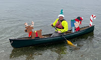
Santa's elves are ready to launch
Its that time of the year when Santa visits cities and towns around the country to get kids excited for Christmas. Usually he arrives by fire truck, but in the coastal village of Wickford he arrives by fire boat, and RICKA members dress-up like elves to escort him down the harbor into town. This year, Michelle decided to come along as well to watch and take some pictures 
from shore.

Wickford is located on the West Passage of Narragansett Bay, and is built around a large, well-protected harbor. It was settled in the early 17th century when Roger William purchased land from the Narragansett Indians and established a trading post. Wickford grew to become a major port and shipbuilding center.

This elf is ready to go
Today, Wickford is a picturesque village whose waterfront streets are lined with shops, restaurants and colonial-era homes. Each year the North Kingstown Chamber of Commerce organizes a Festival of Lights with holiday themed actives. Since 2010, RICKA has participated in this event by escorting Santa down the harbor for his big arrival at the Town Dock.

We arrived at the put-in at the end of Main Street next to Gardners Wharf Seafood at around 11:30 to decorate our boats and get our elf hats and candy canes from Pat. At around 12:10, Michelle walked down to the dock and the rest of us headed over to meet up with Santa for the paddle into town. I am always amazed at the crowd that gathers for this event. 


And I got another poem from Tom - this time on Facebook.

What is appeal
neath cone of teal
with a Blitzen towards the bow?
Well is not it pleasant
that behind the present
canoe there's an elfish pal?
TW

Links:

Tuesday, September 5, 2023

Charles - Medfield to Dover - September 4, 2023

Into the marshland
With family plans this weekend, I decided to get the "early morning crew" together for Labor Day run on the Charles River. Back in the COVID days, the "early morning crew" were my primary paddling partners, doing up-and-back trips and bike shuttles in the early morning to avoid the crowds. We actually did this trip as a bike shuttle back on July 4, 2020.

The Charles River arises at Echo Lake in Hopkinton, and flows generally east for 85-miles, zig-zagging through 22 cities and towns in eastern MA before emptying into Boston Harbor. There are a lots of great flatwater trips on the Charles including the Bays Region from Natick to Wellesley, the Lakes District from Weston to Waltham and the Dedham Loop.

South End Pond
We would be running the section from
Dover Road in Medfield to Bridge Street in Dover - about 5-miles. You can easily extend this trip another 3.5-miles down to the South Natick Dam, but I was looking to finish up before lunch.

We met at 8:00 to run the shuttle and were on the river by 8:45. Most of this trip runs through a large marshland, so it can be hot and exposed in the summer. The river was at a nice level - 1-foot, 250 cfs on the Dover gage. About a mile downstream we took a side trip up Bagastow Brook up to South End Pond. Once back on the Charles we paddled through the section that runs through Rocky Narrows, and took a break at the picnic area. From there it is a quick trip down to the take out. I was on my way home by noon.

It was surprising that the leaves were already starting to turn. Fall is coming. We also saw a few patches of water chestnut on the river. Hopefully a clogged up river isn't coming as well.

Leaves turning at the takeout
Links:

Sunday, August 20, 2023

Seekonk River - August 19, 2023

Our leader Danny
I had some errands to run in Rehoboth, so when I saw that RICKA was running a Flatwater trip on the Seekonk River, I decided to join. 

The Seekonk River is the tidal extension of the Blackstone River that begins just below the Pawtucket Falls. The two rivers could not be more different. The Blackstone is freshwater with lots of twists and turns, while the Seekonk is a tidal estuary that forms the border between Providence and East Providence.

Up the river
We put in at 10:00 at Blackstone Park in Providence (100 Gulf Avenue, Providence) just upstream of the Narragansett Boat Club. The tide was high at noon, so we hit it just about right. We paddled upstream on the Providence side past Swan Point and the Swan Point Cemetery.

The river narrowed as we entered Pawtucket and paddled past Festival Pier (School Street) and the Taft Street boat ramps. The current picked up as we paddled under the Division Street Bridge and the Route 95 Bridge and approached the Pawtucket Falls under the Main Street Bridge.

That's me below the Pawtucket Falls
The Pawtucket Falls is the largest waterfall on the Blackstone River. As we looked upstream over the falls we could see the old Slater Mill. Built in 1793 by Samuel Slater, the Slater Mill was the first successful water powered textile mill in the United States. It began the American Industrial Revolution, and established Pawtucket as a major manufacturing center.

With nowhere left to go, we turned around and headed back downstream. We took a break for lunch at Festival Pier, and then headed down the East Providence side of the river to the Omega Dam on the Ten Mile River.

Omega Dam on the Ten Mile River
In 1636, after escaping religious persecution in Boston, Roger Williams rowed down the Ten Mille River and across the Seekonk River to what is now Blackstone Park. He continued around India Point and up the Providence and Moshassuck Rivers to establish the Providence colony in what is now downtown Providence.

From there, it was a quick trip across the Seekonk River and back to Blackstone Park. Nice trip - glad a brought the Capella.

Gary below the Pawtucket Falls with Slater Mill in the background
This picture inspired a nice poem from Tom - this time Facebook:

Milling about,
don't go out on a limb,
that points to the turmoil,
that's roiling within,
causing one there to yak,
"Dam! Impressive tsunami!"
and approach their Eskimo role,
gulp/gasping, "I want my mommie!"

Links:

Tuesday, July 4, 2023

Providence River - July 4, 2023

Crossing Providence Harbor
I have led a RICKA Flatwater trip on the Providence River on July 4th for the past few years. It seems appropriate since one of the first insurrections of the Revolutionary War – the Gaspee Affair – was carried out on the Providence River in 1772. Providence was also the first colony to declare independence on May 4, 1776, and Rhode Island was the last state to ratify the Constitution in 1790 after protections were added by the Bill of Rights.

The Providence River is formed at the convergence of the Woonasquatucket and Moshassuck Rivers in downtown Providence. It flows south through Providence for a mile to its convergence with the Seekonk River at Bold Point/India Point. It then opens up into Providence Harbor and the Green Jacket Shoal before continuing south for 8-miles to the narrows between Conimicut Point in Warwick and Nayatt Point in Barrington where it becomes Narraganset Bay.

Through the Hurricane Barrier
It was raining as we put-in at Bold Point and paddled up the Seekonk River though the narrows between Bold Point in East Providence and India Point in Providence. India Point was the base of operations for John Brown’s merchant fleet in the second half of the 18th century. John Brown and his brothers would go on to found Brown University.

We paddled past the Brown University Boat House and up to the George Washington Bridge that carries Route 195 over the Seekonk River. In 1776, George Washington marched his army across the Seekonk River at this point on his way to New York after successfully driving the British out of Boston. 

Approaching downtown Providence
We then headed out across Providence Harbor towards the Fox Point Hurricane Barrier. The water was calm and the tide was high, but the rain was coming down heavy. Rounding Fox Point we passed the tugboats before paddling under the I-way Bridge and through the hurricane barrier into downtown Providence.

Providence was established in 1636 by Puritan theologian Roger Williams who was fleeing religious persecution in Boston. It became a major trading center in the 18th century, a manufacturing center in the 19th century, and a financial center in the 20th century. This history can be seen today in the warehouses, mills and office buildings that line the river. We paddled under the Michael S. Van Leesten Memorial Bridge, a pedestrian bridge built on the piers of the old I-195 bridge, and into downtown Providence.

Skyline from the Cove
In the heart of Providence the river passes through Waterplace Park. Completed in 1994, Waterplace Park includes pedestrian bridges over the river that connect over a mile of cobblestone-paved walkways known as the Riverwalk. The park is home to the popular summertime Waterfire events.

We followed the path of Roger Willams up the Providence River to its headwaters at the confluence of the Woonasquatucket and Moshassuck Rivers. We continued up the Woonasquatucket River into the Cove at Waterplace Park. The Woonasquatucket River arises near Primrose Pond and Stump Pond in Smithfield and flows generally southeast for 16-miles to Providence. We paddled under Providence Place and up past the Foundry mill complex before turning around.

Above Providence Place
Since the tide was high, we were also able to paddle up the Moshassuck River to the site where Roger Williams established the Providence colony at the Roger Williams National Memorial. The Moshassuck River arises near Lime Rock in Lincoln and flows generally south for 9-miles to Providence. The river became important during the Industrial Revolution, powering numerous mills (including the Moffett Mill on Great Road) and becoming the lower section of the Blackstone Canal.

By then, the rain has stopped, and we had a leisurely paddle back through the city and across the harbor. I brought my sea kayak so I could practice some of the strokes that I learned at the kayak training on Saturday. We arrived back at Bold Point at around noon - plenty of time to enjoy the rest of the day. Too bad the rest of the day was filled with rain and thunderstorms.

In my sea kayak in front of Providence Innovation District Park
Links:

Saturday, June 24, 2023

Paddling between the rain drops - Assbet River from Acton to Concord - June 24, 2023

At the picnic site below Damondale
Bill and I were scheduled to run a RICKA trip on the Sudbury River through Great Meadows today. Unfortunately, the forecast was for rain and possible thunderstorms and there is no shelter in that wide open marshland, so the Sudbury trip got cancelled. Instead, we decided to run the Assabet River from Acton down to Concord.

The Assabet River arises in Westborough and flows approximately 34 miles west to its convergence with the Sudbury River to form the Concord River. I’ve done a couple of sections of the Assabet including the flatwater section from Gleasondale to the Ben Smith Dam and the whitewater section through Maynard.

Al and Bill navigate the blow-downs
Al had checked the forecast and advised that we should have a window of storm-free weather from 11:00 to 4:00. I met Bill at 9:30 for the drive up to Acton, and it rained the entire time. We ran the shuttle at 10:30, and the rain had stopped by the time we got on the water at around 11:00 – Al was right. I was paddling tandem with Jonathan in my Mohawk - first trip for Jonathan after his hip surgery. Bill was paddling tandem with Al in his Wenonah – first trip for Al in a canoe in years.

The river was low - 1.8 feet, 60 cfs - so finding the deep channels and avoiding rocks and strainers was the order of the day. We ran through the site of the old Damondale Dam, and took a break for lunch at the new picnic site just downstream.

Erik and Jonathan at Egg Rock
From there we entered a section with numerous blow-downs. A couple were tricky, but we were able to paddle over or around them all without getting out of the boat. We stopped again at the boat ramp in West Concord and walked over to D&D for a coffee - it was an leasurly trip. (There is also a new picnic site downstream of the bridge in West Concord). From there it is an easy paddle down to Leaning Hemlocks with its memorial to paddler and poet George Bartlett with the words from his poem Floating Hearts. We continued down to Egg Rock at the convergence of the Assabet and Sudbury Rivers.

As is tradition, we continued down the Concord River to the Old North Bridge and the Minute Man National Historic Park. It was approaching 4:00, and sure enough the rain started up again. It was a brief shower and we took refuge under the Old North Bridge until it passed. It did rain for much of the ride home. Our timing was good.

Jonathan and Erik at the Old North Bridge
Links:
My Pictures
Maynard Gage
Floating Hearts – Poem by George Bartlett

Wednesday, June 21, 2023

Rice City Pond with the Blackstone Valley Paddle Club - June 20, 2023

Up the old Blackstone Canal
It was my turn to lead the Blackstone Valley Paddle Club at River Bend Farm. I scouted the canal/river loop last weekend, but the water was a little low and there were too many strainers, so we decided to stay on Rice City Pond.

The Blackstone Valley Paddle Club was established in 2000 by the Blackstone River Valley National Heritage Corridor (now Park and Corridor). I became a paddle club leader in 2007. Over the years, the club has led Tuesday night trips throughout the summer, getting thousands of people out on the waterways of the Blackstone River Valley. We had a good turn-out for this trip with around 19 boats.

At the Goat Hill Lock
Rice City Pond is part of the Blackstone River Canal and Heritage Park – a 1,000-acre state park in Uxbridge, MA with hiking trails, paddling on the Blackstone River and Canal and historical sites like the Blackstone Canal’s Goat Hill Lock, King Philip’s Lookout and the Stanley Woolen Mill.

We put-in at the Tri-River Medical Center and paddled upstream under the Stone Arch Bridge at Hartford Avenue and up an old section of the Blackstone Canal to the Goat Hill Lock - one of only two remaining locks. The other is the Millville Lock above the Blackstone Gorge.

Up the Blackstone River
Following the demise of the Blackstone Canal, this section of the canal was purchased by the Taft family who converted it to a mill race for the Stanley Woolen Mill. They built the dam that created Rice City Pond, and constructed new headgates to control the flow of water down to the mill.

We paddled across the top of Rice City Pond and up a section of the Blackstone River before shallow water forced us to turn around and head back to the put-in – nice night.

Heading back to the put-in
Links:

Sunday, June 11, 2023

RICKA Flatwater Training - June 11, 2023

I was at Stump Pond today for the RICKA Flatwater Training. Bill and I have been involved in this training since at least 2010. Paul helped out this year as well. New paddlers learned basic strokes, and for the first time we also did solo canoe training. The water was cold, but we still had several people do wet exits and assisted rescues.  

Crew for the Flatwater Training
Links:

Wednesday, May 24, 2023

West River with the BVPC - May 23, 2023

The open boaters 
I saw on Facebook that Danny and Bill would be joining the Tuesday night trip with the Blackstone Valley Paddle Club on the West River in Uxbridge, so I decided to join as well. Open boaters make every trip better.

The West River in MA (not to be confused with the West River in VT) arises at Silver Lake and Cider Mill Pond in Grafton and flows south for approximately 13-miles to its convergence with the Blackstone River in Uxbridge. The river was a source of power for several textile mills during the early stages of the Industrial Revolution.

Heading out
As part of the flood control work completed after Hurricanes Connie and Diane in 1955, a large flood control dam was built on the West River by the Army Corps of Engineers. The flood control land now includes 600 acres of woodland and marshland along the river and upstream in the towns of Uxbridge, Northbridge and Upton.

On this trip we would be paddling from West River Road in Uxbridge up to the flood control dam. By late spring or early summer, the backwater from the dam just above Mendon Street (Route 16) is full of invasive weeds, so this trip needs to be done early in the season. We paddled upstream over two beaver dams. The river that twists and turns through pretty woodlands and marshland as we made our way up the West Hill Dam and back.

The crew at the put-in
Links:

Wednesday, May 17, 2023

Lackey Dam with the BVPC - May 16, 2023

Heading out on the pond
With Mother’s Day and our recent trip to Florida, it’s been a couple of weeks since I was out in my canoe. I decided to join the Tuesday night trip with the Blackstone Valley Paddle Club.

The Blackstone Valley Paddle Club was established in 2000 by the Blackstone River Valley National Heritage Corridor (now Park and Corridor) as a way to get folks out on waterways of the Blackstone River Valley. Over the years, the club has continued its Tuesday night summer trips getting thousands of people out on the water.

Up the Mumford River
This paddle would be on the Mumford River above the Lackey Dam. The Mumford River arises at Manchaug Pond in Sutton and Douglas, and flows 18-miles east until it joins the Blackstone River in Uxbridge. The many dams along the river provided power to 19th century textile mills. We had a good turn-out for this trip with 15 boats, including 2 canoes.

The crew was heading out when I arrived, so I paddled sweep with Cheryl and Tom. Early in the season the pond is clear, but later in the summer it will get choked-up with water chestnuts. We could see the young water chestnut plants growing up in the shallow water. We paddled up the pond into the Mumford River and up beyond Route 146. Fallen trees make this a little challenging once you get into the river, but you can actually make it quite a ways up.

Heading back down the pond to the put-in
Links
My Pictures

Monday, March 20, 2023

River Bend Farm – March 19, 2023

At the put-in on the Blackstone River
We had a family party on Saturday, and I needed to help at the Saint Joseph’s Day Mass on Sunday, so I had to stay close to home this weekend. I did want to test out my new drysuit, so I ended up running the canal/river loop at River Bend Farm.

River Bend Farm is part of the Blackstone River Canal and Heritage Park – a 1,000-acre state park in Uxbridge, MA with hiking trails, paddling on the Blackstone River and Canal and historical sites like the Blackstone Canal’s Goat Hill Lock, King Philip’s Lookout and the Stanley Woolen Mill.

Water flowing over the spillway dam
I parked at the Tri-River Medical Center and carried my boat over to the put-in on the Blackstone River below the spillway dam. The day was sunny with a little wind and temps in the mid-40's. The river was high - 4.5-feet, 1,000 cfs on the Northbridge gage. Water was flowing over the spillway dam, which you don't see very often.

At this level the river moves fast, and the trick is to stay in the current on the seam between the fast moving water on the outside of the turn that is often filled with strainers, and the huge eddies on the inside of the turn that will quickly spin you around. The river section went quick and I was soon at the take-out for the portage over to the Blackstone Canal.

Blackstone Arch
The Blackstone Canal opened in 1828 and utilized a series of 49 locks to move the barges up and down the 450-foot difference in elevation from Providence to Worcester. The canal operated until 1847 when it was replaced by the Providence & Worcester Railroad. Following the demise of the Blackstone Canal, the section through what is now River Bend Farm was purchased by the Taft family who converted it to a mill race for their Central Woolen Mill. Later known Stanley Woolen Mill, it would become one of the most successful woolen manufacturers in the country.

I was paddling against a slight downstream current as I headed back up the canal. There were a couple of strainers across the canal, but I was able to get around or over them without portaging. After snapping a few pictures of the River Bend Farm Visitor Center, I was soon back at my car for the trip home.  My new drysuit worked great - a little baggy, but very comfortable.  

River Bend Farm Visitor Center from the Blackstone Canal
Links:

Sunday, August 21, 2022

Hot Day on the Sudbury – August 20, 2022

Heading out into the marshlands
A trip in August in the wide open marshlands of the Great Meadows Wildlife Refuge on the Sudbury River seemed like a good idea when Bill and I put it on the RICKA Flatwater calendar back in April. We knew there would be water, but we hadn't thought about how hot it can get in the dog days of summer, or the total lack of shade.

The Sudbury is a National Wild and Scenic River that arises in Westborough and flows generally northeast for 41-miles to its convergence with the Assabet at Egg Rock in Concord. From there the river continues as the Concord, which flows generally north for about 16-miles until its convergence with the Merrimack River in Lowell.

I
Me and Bill in the Spirit II
n the towns of Sudbury and Wayland, the Sudbury River flows through the wetlands of the Great Meadows National Wildlife Refuge. It is a beautiful area that provides habitat for migratory bids and many other animals. Bill and I have been doing RICKA trips on the Sudbury for the past couple of years.  

We put-in at 9:30 at the Lincoln Canoe Launch (Route 117). With the ongoing drought, the water at the launch itself was a low, but the river was fine. We paddled upstream into the marshes for about 4-miles before turning around and stopping for lunch under the bridge at Sherman’s Bridge Road - the only shade we could find. Temps hit the low 90’s, so it was HOT out on the water, but a trip to Bedford Farms in Concord for ice cream made up for it. John put together this video:


Links:

Sunday, July 10, 2022

RICKA Flatwater Training - July 9, 2022

Assisted rescue with Bill
I was back on the Woonasquatucket River on Saturday – this time at the Stillwater Reservoir or Stump Pond in Smithfield. 

With COVID, it has been a couple of years since RICKA has done much in the way of training, but we were doing a Flatwater session for new and experienced paddlers. New paddlers learned basic strokes, and everybody got to practice deep water rescues. We had nine “students” with four “facilitators” and a mix of boats – sea kayaks, rec. kayaks, a solo canoe and a tandem canoe.

Getting the big boat up on the gunwales
It wasn’t always pretty, but everybody did a wet exit and was able to get in the boat. No surprise that sea kayaks with bulkheads were the easiest to get empty. For me, the shorter the rec. kayak the tougher it was to get up on the gunwales to empty (might be easier for someone in a kayak). 

I was able to get my solo canoe empty with a flip, but couldn’t get back in the boat unassisted without swamping it again - assisted I was fine. Chuck and Cindy in the tandem boat got back in unassisted a couple of different ways (one-on-each-side and stirrup) but couldn’t get the boat empty unassisted. That’s a big boat to try to flip, or even lug over the gunwales.

Chuck and Cindy back in the boat
Links: