Sunday, April 28, 2019

The “Mighty Quin” – April 27, 2019

Erik runs the put-in drop
With all the rain we had this week, I knew there would be lots of rivers running this weekend. My original plan was to run the Woodstock section of the Pemigewasset River in NH, but that trip got cancelled when the river came close to flood stage at 8,000 cfs. My back-up plan was the Scantic River in CT, but that trip also got cancelled due to high water. In the end, Paul and I joined Andrew and Michael for a run on the Quinapoxet River, or the “Mighty Quin” - a nice class II/III stream located close to home about seven miles north of Worcester.

The Quinapoxet River arises in Princeton, MA, and is part of the MWRA system supplying drinking water to greater Boston. The Quinapoxet Dam in Holden impounds a billion gallons of water in the Quinapoxet Reservoir. Below the dam, the Quinapoxet River flows 8-miles east to the Wachusett Reservoir, joining the Stillwater River to become the South Branch of the Nashua River in West Boylston.

Paul runs the put-in drop
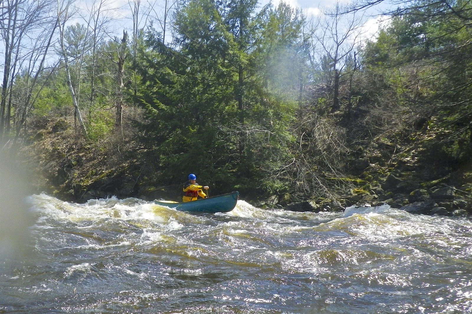
We would be running the 3-mile section of the Quinapoxet River from River Street in Holden to the Wachusett Reservoir in West Boylston. It’s a trip that can be tough to catch, and this would only be my third run on the river. The minimum level for this trip is about 8.5-feet. I had run it before at around 10-feet. On this trip, the level would be just under 11 feet, 700 cfs. – high and fast.

After dropping my boat at the put-in, I met Paul, Andrew and Michael at the take-out to run the shuttle.  When I returned to my boat, I found that I had punctured the rear float bag when I locked my boat to a tree.  Float bags are used in canoes and kayaks to keep the boat from filling with water and pinning on rocks if you swim. I decided to do the trip anyway, but knew I would have to be careful not to swim. 

Andrew does some surfing
The river starts off with a two-foot drop at an old broken dam. There is a large standing wave and play hole at the bottom.  We all ran the drop, but only Andrew ventured into the play hole to try his luck at surfing – his luck was good.  

As we headed downstream, the river twists and turns though a pretty hemlock forest. Much of this area is maintained as open space as part of the Wachusett Greenway. I had hiked along the river several times with Bill and the “Papa Joe” hiking group, but it was nice to be paddling it again.  We enjoyed the class II waves and rock-dodging down to the Springdale Mill.  

Heading downstream
At the Springdale Mill site, the action picks up a bit with a class III rapid at another broken dam. The easiest line though this rapid is to stay left and catch the big eddy just downstream of the dam. I went through last, and just caught the tail-end of the eddy – a close call averted.

Below Springdale are more class II rapids down to the Interstate 190 crossing, where there is an abrupt 3-foot drop. The kayaks ran this drop down the middle, blasting through the large standing wave at the bottom. I found a drier line on the right, which avoids the big wave. Above the drop is an intense rapid with rocks in the middle - I went left.  

Paul and Andrew start their second run
From there, it is more class II waves and rock-dodging down to the take out.  It’s a short run, so we were done in about an hour.  With a blown-out float bag, I figured that I had pressed my luck enough, so I opted out of a second run.  I shuttled Paul, Andrew and Michael back to the put-in before heading home. Another great day.  

Links:

Saturday, April 20, 2019

Plummers Landing to Route 16 - April 20, 2019

At the put-in
Bill and I had to put up with a little rain, and a few blow-downs, but we still had a nice run down the Blackstone from Plummers Landing to Route 16. The level was great (5 feet, 800 cfs), and there was lots of wildlife out – herons, turkeys, deer, osprey, a red tail hawk, and even a Bald Eagle. Two blow-downs completely blocked the river just after the canal, but the portage was easy. Otherwise, we were able to paddle over or around everything.

Rice City Dam the and Hartford Avenue Bridge
Links:

Sunday, April 14, 2019

A Spring Tradition - Upper Millers - April 14, 2019

Running the broken dam
It has become a tradition for me to paddle the spring release on the Upper Millers. I ran this river for the first time with Mike B. back in 2007. Since then it has become one of my favorite trips.  

The Millers River arises in north-central MA and flows generally west for 52 miles to converge with the Connecticut River at Millers Falls. There are two sections that are popular for whitewater boating – the Upper Millers from Royalston to Athol (class II/III), and the Lower Millers from Erving to Millers Falls (class II/IV). 

Below the first railroad bridge
The open boaters outnumbered the kayakers on this trip with 9 canoes and 3 kayaks. If you are a Millbrook Boat fan, there were plenty – 1 Blink, 1 Shacho, 2 20/20’s, 2 Outrages and a tandem Prowler. Dan was paddling a Silverbirch, so I was feeling a little old-school in my Dagger Encore.

The day was warm, but started off cloudy and rainy. The gage was off-line, but the typical release is 1,500 cfs, and it was at least that. Some of the crew put-in at the Birch Hill Dam and ran the broken dam above the usual put-in. I opted to take some pictures.

Below the second railroad bridge
The trip alternates between class II and III rapids, with some quiet water in between. The first class III rapid starts just below the put-in and continues down to the first railroad bridge. After a bit of quietwater, the second class III rapid – Mile Long - begins at a sharp left turn. The third class III rapid begins after some class II rapids after the second railroad bridge. The last class III rapid is the Gorge that begins below the big waves at the lunch spot. 

I spent most of my time dodging rocks and dumping out my boat. By the time we reached the take-out the day was sunny and warm – it felt like spring.  

Riding the waves
Links:

Sunday, April 7, 2019

Crystal Section of the Farmington - April 6, 2019

Milana
It’s been 4-years since I took a trip out to the Crystal (Collinsville to Unionville) section of the Farmington.  When I saw a trip posted by New York-Northern New Jersey Chapter on the AMC website, I decided it was time for a return visit.  

The Farmington arises near Otis, MA and flows generally south and east for 47 miles through Connecticut until it flows into the Connecticut River near Windsor. There are several sections of the Farmington that are popular for whitewater boating – New Boston (class III/IV), “Tville” or the Tariffville Gorge (class (II/III), Riverton/Satan’s Kingdom (class I/II), and of course Crystal (class II).

Neil
The river was dropping on Friday as final plans were being made, so we met at the commuter lot off Route 8 in case we needed to change to a different river.  As it turned out, rain on Friday night brought the river back up to a nice level – 6.2 feet, 800 cfs.  

We had eight boats for the trip - six canoes (me, Neil, Paul, Charles, Stephan and Mary Ann) and two kayaks (Oleg and Milana). It was raining when I left Rhode Island, but sunny and warm when we put in at the river.

Oleg
We put-in just below the Collinsville Dam and began our run. This section is about 3-miles long and includes a series of class I/II rapids that get more difficult as you move downstream. The first major rapid is the site of the Punch Brook Slalom, and the gates were being installed as we paddled through. I was able to hit most of the gates, but it wasn't easy, and I certainly wasn’t fast.  

From here, the rapids continue as a series of rock gardens and wave trains. The largest is the ledge above the Route 4 Bridge that we ran to the right. The run took us about 4-hours. We took-out at the bike trail parking lot below the Red Barn.

Charles

Links: