Showing posts with label Whitewater. Show all posts

Sunday, August 24, 2025

Fife Brook in my Millbrook Outrage - August 22, 2025

Running Zoar Gap
I knew I was going to have a busy weekend, so when a saw a post for a Friday afternoon trip on Fife Brook I decided to join. This would be the first whitewater run in my new Millbrook Outrage, and I got Paul to come along as well.

We met at 12:30 at the take out below the Gap. I was surprised how many people were around for a weekday trip. We had 11 in our group – 4 canoes and 7 kayaks – and there were 3 other groups organizing to get on the river. The release was 800 cfs – an OK level, but a little boney in spots.

Running Zoar Gap
We got on the water at around 1:15, and I could tell right away that the composite Outrage was different than its Royalex cousin. It’s hard to describe, but it made the Royalex version feel a little sluggish. The composite boat was definitely faster, the turns were crisper, and it was really dry. I've always admired the Millbrook guys who were bailing out their boats with sponges – now I know why.

We worked out way downstream, and the boat felt more comfortable the more I paddled it. When we finally got to Zoar Gap I was the last one to go through. I caught a couple of eddies on the left on the way down, and the two big rocks on the right before heading in. I took the line from right to left, and made it through fine. 

Running Zoar Gap over the Years

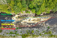
Routes through Zoar Gap over the years
There have been three different versions of the "Gap" since I started paddling in 2006. Back in the old days there was an easy "sneak" route on the far right (red). That got filled with rocks during Tropical Storm Irene in 2012. After that, I usually eddied out at the top and tried to go right or left of "Oh Shit Rock" in the middle of the second drop, with mixed success (yellow going right). After flooding in 2023 things got moved around again. The eddy at the top got squirrely, the right line got blocked by rocks, but cutting directly from right to left got a lot easier (blue). There has always been a kayak line of the far left (green). Here are some of my runs over the years:


My Zoar Gap record now stands at 21 attempts with 13 successful, 6 swims and 2 walks. I’ve made it through successfully on my last 5 runs.

Monday, August 11, 2025

Dead - Spencer Stream to West Forks - August 9, 2025

The boats get loaded
There are rivers that aren’t too difficult if you take the right lines, but can be brutal if you don’t. I was on one of these rivers on Saturday – the Dead in ME, and I paid the price for a bad line on the last rapid - Lower Poplar. My first swim of the year.

The Dead is one of the longest continuous whitewater runs in the Northeast with approximately thirty rapids along a fourteen-mile stretch. The river is mostly boulder-type rapids with lots of holes and pour-overs. The shoreline has thick vegetation that grows right up to the river's edge that can make it difficult to rescue swimmers or bail out an open boat. The major named rapids are:
  • Spencer Rips –big weaves are to the right, big eddy below on left to stop and regroup.
  • Minefield (2 miles) – long boulder garden with big waves and lots of holes – difficulty increases where the river turns left.
  • Hyden’s – (3 miles) good lunch spot – run in middle and stay out of holes.
  • Gravel Pit (4.5 miles)
  • Enchanted Stream (7 miles) – another good lunch spot.
  • Elephant Rock – (7.5 miles) a river wide ledge immediately below Enchanted Stream. You can run the big waves in the center, or the slot on the right between Elephant Rock and the rock wall.
  • Mile Long (8.5 miles) – another long boulder garden with big waves and lots of holes. There is an eddy on the left about half-way down
  • Upper Spruce Ledge (10.5 miles)
  • Lower Spruce Ledge (11 miles)
  • Upper Poplar Falls (11.5 miles) – short but intense rapid filled with rocks and holes. Go right and stay away from holes – stop in big eddy bottom right.
  • Lower Poplar Falls (12 miles) – a longer intense rapid that tumbles down the left side in huge wave trains and large holes. Left is hero line with lots of dangerous holes. The right line along the boulder garden is the usual open boat route.
Heading out
I picked up Paul for the six hour drive up to the Forks. We stayed in a two-person cabin-tent at Northern Outdoors. We had a small fire on Friday before settling in for the night.

We were up early Saturday morning to meet our group and the shuttle. We were paddling with the Penobscot Paddle and Chowder Society - aka the Chowder Heads. We had a group with 13 boats – 6 canoes, 6 kayaks and 1 shredder.

Charlie in one of the unnamed rapids
Old-time Dead River paddlers probably remember Webb’s Shuttle Service run by Ed Webb. Webb's (later Riverdrivers) no longer provides shuttle service, so we met the new shuttle company - Ironbound Outdoors - at 8:00 at the Public Takeout on Dead River Roar in West Forks.

With the large group of MVP'ers running the Dead for a step-up weekend, it took forever to load the boats. We finally got on the road around 9:30, and got to the river about 45 minutes later after a long, bumpy, dusty trip down 20-miles of dirt logging roads. We finally got on the water around 11:00.

Paul running Lower Poplar
The release was supposed to be 2,400 cfs, but was closer to 2,100 cfs with 25 cfs from Spencer Stream - a nice class II/III. At lower levels (1,200 cfs to 1,800 cfs) it is primarily class II except for the very first, and last couple of rapids. At medium levels (2,000 cfs to 3,500 cfs) it is mostly class III. At higher levels (4,500 cfs to–8,000 cfs) it is class IV.

We ran through Spencer Rips, Minefield and some other unnamed rapids before stopping for lunch at Hayden's. Then we ran Hayden's, Gravel Pit and some other unnamed rapids before taking a break at Enchanted Stream. Paul wanted to get some video so I ran the big waves in the middle of the ledge at Elephant Rock rather than the shoot on the right.

Erik running Lower Poplar
The next major rapid was Mile Long – another long boulder garden with big waves and lots of holes I filled my boat about half way down, but was able to empty it in a big eddy on the left before finishing the rapid. After running the Upper and Lower Spruce Ledges we took a break at the Poplar Portage Trail before taking on Upper and Lower Poplar.

Upper Poplar is a short but intense rapid filled with rocks and holes. Most of us ran it to the right and made it through fine. Lower Poplar was another story. The river turns right along a boulder garden as the water tumbles down the left side in huge wave trains and large holes.

Swimming Lower Poplar
Most of the open boats took the right line along the seam between the boulder garden and the big holes. As I was coming down I saw Charlie flip in front of me. I got around him to the left, but now I was  out in the big holes and pour-overs. Before long, my boat was full of water and I was struggling to keep it upright, never mind avoiding the rocks and holes. About half way down, I went sideways over a large rock into a hole, and over I went.

As I swam downstream I looked back to see my canoe still stuck in the hole. That was the least of my problems. Swimming through rapids is something that I try to practice, but it doesn’t match the real experience. First, I swam though a series of “haystacks” or standing waves where you have to breathe in the trough, and hold your breath as you go through the wave - breathe, glug, breathe, glug, breathe, glug.

Reunited with my boat at
the bottom of Lower Poplar
After the waves, I could see a horizon line downstream indicating that I was approaching a rock with a hole on the other side. I tucked into a ball as best I could as I went into the hole. When I came out the other side Paul was yelling at me to swim hard to the left shore since I was approaching another big hole. I wasn’t making much progress so I threw away my paddle thinking that would allow me to swim better. After more waves, rocks and holes, I finally got myself to shore. It was about a 200-yard swim, but it seemed like forever.

After I caught my breath I looked over and could see Paul on the other side of the river with my boat. I was about to jump in the shredder for a ride to the other side when Craig paddled over towing my boat. I had paddled through 30 rapids over 14-miles only to swim the last 200-yards. We had 3 other open boaters swim Lower Poplar, so I guess I shouldn't feel too bad. 


The swim earned me a new poem from Tom.

It’s really not an Outrage,
until one’s stood on end.
But chill we will baptised beginning,
again, again, again.

If that ol’ paddler’s adage, “Ya ain’t really learnin’ unless yer gettin’ wet,” holds any water, we’re gonna have t’call ya, Doctor Dunk, Erik.

Man’s gotta do what a man’s gotta do.
TW

Sunday, June 22, 2025

Fife Brook - Pride Day on the Deerfield - June 21, 2025

Paul, Fran and me
It was a day to show support LGBTQ+ folks, and to encourage everyone to get out and paddle. Who wouldn’t want to do that. Besides, it has been a while since I’ve done a run on the Fife Brook section of the Deerfield River, so I was glad when Paul posted this trip on RICKA’s Flatwater calendar. 

There are several sections of the Deerfield that are popular for whitewater paddling. Advanced paddlers often head to the Dryway in Monroe Bridge. This is a class III-IV section of river for experienced whitewater paddlers. We would be paddling the Fife Brook section, which is mostly class II, with the exception of Zoar Gap in the middle which is class III.

Paul and Fran
I met Paul at the take out below the Gap at 11:00. There were lots of people looking for rides, so I ended up taking Mary Theresa’s boat and aother paddler – Seth – up to the put-in. We hung out for a while waiting for the water to come up and got on the river a little after noon.

The day was sunny and warm – first trip in swim trunks and a tee shirt. The Fife Brook Dam was supposed to release 1,200 – not sure it actually did but it was still a good level. Just downstream from the put-in is the first rapid known as Hangover Helper - a ledge extends across most of the river resulting in a 2-foot drop followed by a long wave train. We ran the drop and played in the waves before moving downstream.

Fran in the Island Rapid
The next rapid - Carbis Bend - is similar but smaller. A ledge extends out from the left side of the river producing a couple of easy surf waves. Just downstream from Carbis Bend is a rapid known as Freight Train. This rapid starts with a long wave train and ends with a large surf wave. The rapid takes its name from the speed that many people build up running through the waves, and the railroad bridge just downstream that carries freight trains across the river.

After Freight Train is a rock garden known as Pinball. With scattered rocks and ledges, it’s a great place to practice eddy turns, peel outs and ferries. After Pinball is the Island Rapid. As the name describes, the river is split by an island. The usual route is to the left with large waves and fast moving water where the river reconnects at the end.

Approaching Zoar Gap
After the Island Rapid comes Zoar Gap – the largest rapid on this section of the river. Paul went through first, caught the eddy after the first drop, but couldn’t spin his boat around to run the second drop. He ended up running the shoot backwards and dumped on the big curling wave at the bottom. I took the line from right to left, skipped the eddy, and made it through fine.

After the gap, we continued downstream to the Shunpike Rest Area.  As ususal, we stopped for sub’s on the way home at Georgio's Pizza in Greenfield. I took Route 2 home to avoid the construction on the MassPike.


Links:

Friday, June 20, 2025

Thursday Night Tville - June 19, 2025

Party Wave
With hot weather and the Juneteenth holiday, it seemed like a great day to do a Thursday Night Tville run on the Farmington River. It is amazing that we are in late June and Tville is still going strong.

The Farmington River arises near Otis, MA and flows generally south and east for 47-miles through Connecticut until it reaches the Connecticut River near Windsor, CT. There are several sections of the Farmington that are popular for whitewater boating – New Boston (class III/IV), Riverton/Satan’s Kingdom (class I/II), Crystal (class II), and of course “Tville” or the Tariffville Gorge (class II/III).

Playhole
Tville is one of the best-known whitewater runs in southern New England. It is the site of an annual spring slalom race and has hosted national and Olympic trials. The run itself is short - just 1.5 miles, but the water runs most of the year and there are play spots for paddlers of all skill levels. At yesterday’s level – 2.4-feet, 1,000 cfs - it is a class II+ run, with a couple of class III rapids at the end.

We met at Tarrifville Park and ran the shuttle down to the take-out at Taxis Avenue. We had 16 in the group – 15 kayaks and 1 canoe - what else is new. These was plenty of water at the top, and at Cathy’s Wave and Brown's Ledge. I ran the Bridge Abutment Rapid first and got some pictures of the rest of the group coming through.

Top of Double Drop
As usual, I ran the rapids above the Play Hole to the left and got out to get some picture of the kayaks in the Playhole. Below the Playhole are three ledges that I run to the left. I did get some pictures of folks running the bigger drop on the right.

I ran double drop to the right and caught the eddy. The water was moving fast between the drops, but I was able to catch a wave trough, which made it easy to ferry over to the other side to run the second drop. At this level, I could have run the first drop on the left and avoided the ferry.

Sunset on the river
We headed down to Typewriter, but with the island in the middle wearing away, the surf wave was not as big. I peeled out just as Ed was coming through with one of the newer paddlers. As we got into the squirrely water below Typewriter, I actually ran Ed over after tipping him over. He rolled back up no worse for wear.

We finally made to the takeout by around 8:00. I loaded up my gear, changed up and was on my way in about 15 minutes. It seems like a longer drive home at night. I get home around 10:00.

Surfing at Cathy's Wave
Links:

Saturday, June 7, 2025

Crystal - June 7, 2025

Punch Brook
My original plan was to do the RICKA Flatwater trip on the Upper Wood River, but it got cancelled due to rain. My second option was the RICKA sea kayak trip at Potter Cove, but it got postponed until tomorrow. I needed to paddle today, so I sent an email to Paul D. to see what he was doing. We decided to do an early run on the Crystal section of the Farmington River to beat the rain.

The Farmington arises near Otis, MA and flows generally south and east for 47 miles through Connecticut until it flows into the Connecticut River near Windsor. There are several sections of the Farmington that are popular for whitewater boating – New Boston - class III/IV (1, 2, 3), “Tville” or the Tariffville Gorge - class II/III, Riverton - class I, Satan’s Kingdom - class I/II(III), and of course Crystal - class II.

Ledge above Route 4
I met Paul at the put in at 9:00. We unloaded the boat and ran the shuttle down to the Red Barn. The river was running at 6.5 feet, 1,100 cfs – a great level with lots of play spots. The run is a series of class I/II rapids that start off easy and get more difficult as you move downstream.

The first major rapid is the site of the Punch Brook Slalom. From there, the rapids continue as a series of rock gardens and wave trains. We spent a lot of time surfing and ferrying through the rock gardens. The largest rapid is the ledge above the Route 4 Bridge that we ran to the right. The run took about 3-hours and I was on the road back home by 12:30. We beat the rain on the river, but it poured on the way home.

Links:

Sunday, May 4, 2025

RICKA trip on Otter Brook - May 4, 2025

Awaiting to launch
Paul posted a couple of RICKA trips on the Whitewater Message Board this spring – both were old favorites. The first was the Knightville section of the Westfield, and the second was Otter Brook.


Otter Brook arises in the town of Stoddard and flows south for 13-miles to join Miniwawa Brook at Route 101 to form the Branch River. The Branch River flows into the Ashuelot River, which eventually flows into the Connecticut River. Jonathan and I did a tandem run down Otter Brook and the Branch River all the way to the Sawyers Crossing Covered Bridge on the Ashuelot River a couple of years ago.

Rapid below the put in
In 1958, the huge
Otter Brook Flood Control Dam was completed to protect Keene and the other communities along the Ashuelot River. The flow on Otter Brook is now controlled by releases from the dam. The gage on Otter Brook is no longer active, but the historical releases were around 300 cfs.

I met Paul at McD’s for the drive up to the river. We met the crew at the put-in at the base of the dam. It was not a particularly busy day, but we did see groups from MOC and CTAMC. We unloaded our boats and ran the shuttle. The usual take out on Swanzey Factory Road was filled with construction equipment, so we used a new take out just downstream at the Cheshire Railroad Stone Arch Bridge on the Cheshire Rail Trail.

Running Otter Ledge
We were the first to launch and head downstream. The top of Otter Brook is narrow and rocky as it twists and turns through the woods down to Route 101. We worked our way downstream dodging rocks and running waves. We ran Otter Ledge through the slot on the right, and everyone made it through fine. With additional water from Miniwawa Brook, the river opens up and we bounced down the final section along Route 101.


Taking out at the rail trail bridge adds one more rapid to the trip. On the first run I wasn’t sure where to take out, so I had the crew take out too far upstream. We had to drag our boats across a grassy swamp to the cars. Paul went a little further downstream and found the actual take out on river right just above the bridge.

Down to the new take out
After a slightly confused shuttle we got all the cars, boats and people in the right places for our second run. It was a bomber run, and everyone did fine. This time we took our down by the bridge and ran one last shuttle back to pick up the cars.


On the way home, Paul and I stopped at the Troy Deli and Marketplace for a steak and cheese sub. I’ll bet there will be a RICKA Whitewater trip on the Fife Brook section of the Deerfield this summer.

Links:

Monday, April 21, 2025

RICKA trip on the Knightville section of the Westfield - April 19, 2025

Group picture for the Jim O'Brien Memorial
In 2010, well-known local paddler Jim O'Brien died in a tragic boating accident on Hubbard Brook. Each year, his friends organize a memorial paddle in his memory on his home river – the Knightville section of the Westfield. Its dam-controlled so there is always water, and there is always a big crowd. It is the bumper-boats of whitewater paddling, and Paul posted a trip on the RICKA Whitewater Message Board.

The Westfield River arises in the Berkshires and flows generally southeast for 78 miles to its confluence with the Connecticut River in Agawam. The river has lots of great whitewater paddling on three branches that join in Huntington to form the main stem - the North Branch (sometimes called the East Branch) that includes Pork Barrel, the Middle Branch, and the West Branch that includes Knightville.

Paul and I heading down
This is also the weekend of the Westfield River Wildwater Race, so there is a big crowd along the river as well. As I was bringing my boat up to the put-in I saw racers coming down the expert course, and saw Rick at the finish line at the gazebo. 

After dropping my boat up at the dam, I drove back to the parking lot at the Huntington Health Center and waited for Aaron to pick up for a ride back to the put-in. We got into the group picture before heading out with the rest of the crew. We had a mixed group (2 canoes and 2 kayaks) and first-time runs for Aaron and Logan. The river was at nice level 5-feet, 1,100 cfs – a typical dam release level. 

Aaron running the Gorge Drop
The run is mostly class II rock dodging until you get to the Gorge in the Gardner State Park. We had one swim on the top half, but after a quick rescue we were back on our way. The Gorge Drop is a 3-foot ledge to the right of a large jumble of rocks. The easiest line is just to the right of the rocks. From there you can either catch the eddy behind the rocks, or ride the haystack waves downstream.

I went through first and caught the eddy behind the rocks. Unfortunately, I didn’t get my camera out in time to catch Paul and Logan coming through, but I did catch Aaron. From the Gorge Drop down to the take-out is quickwater and more class II rock-dodging. Here's my edit from Aaron's helmet camera video.


Saturday, April 5, 2025

Sugar River - April 5, 2025

The crew at the put-in
There were a few different options for today, but I decided to join the NHAMC for a run on the Sugar River. We would be paddling the section from Corbin Road to Route 103 that I fist paddled as a student in NHAMC Whitewater School back in April 2005.

The Sugar River originates at Lake Sunapee and flows generally west for 27-miles to join the Connecticut River in Claremont, NH. My father was an active NHAMC member, so when I first got into paddling I signed up for their whitewater school. It was a two-day class with the first day spent on flatwater and the second day on this river.

Running Sweet Tooth
Today, the river was at a nice level – 3-feet, 1,000 cfs on the West Claremont gage. I was the only open boater paddling with 6 kayakers. We put-in at the covered bridge and headed downstream. The river starts off with easy class I/II rapids until you reach Sweet Tooth – the largest rapid on this section of the river

Sweet Tooth takes its name from two large boulders just left of center with the easier line to the right, and the spicier to the left. Four of us ran it successfully on the right. Three chose a spicier route left resulting in one out of boat experience. From Sweet Tooth to the take-out is a fun section that is pretty much continuous class II.

Sunday, March 30, 2025

Tandem at the Scantic Spring Splash - March 29, 2024

Opening Ceremony 
I’m not much of a canoe racer, but I’ve always loved watching the carnage at the Scantic Spring Splash Canoe and Kayak Race – especially the tandem canoes. I have run the Scantic many times in my solo canoes. This year I wanted to try a tandem run, so I partnered with Aaron for a run in my Mohawk Whitewater 16.

The Scantic arises in Hampden, MA (southeast of Springfield) and flows general southwest for 40-miles to join the Connecticut River in South Windsor, CT. We would be running the "Expert Course" from Quality Avenue in Somers to the Powder Hollow Barn on South Maple Street in Hazardville – about 5-miles. 

Competition takes a swim above Trestle
Much like RICKA’s old Branch River Race (AKA Rhode Island Whitewater Championship), the Scantic Spring Splash is a downriver race with four significant rapids. On the Branch the rapids are below the Harrisville Bridge, Whipple Drop, Glendale and Oakland. On the Scantic they are Trestle, Stokers, Chimney and Staircase. 

I dropped off my boat at the put-in and headed down to the barn to register with Aaron and pick up our bib. We got number 29. We then caught the shuttle bus back to the put-in. 

Running Stokers
After the mandatory safety meeting we got on the water at around noon with our class – Men's OC2 – Masters (AKA the “old fogey” group). There was only one other boat in our class, so we were guaranteed to place. We launched first and headed downstream. 

Even with the dam release the river was very low - .75-feet, 22 cfs on the Broad Brook gage. The race starts off with 2.5-miles of quickwater, and we scraped and bumped our way down the upper section. At one point we grounded on a gravel bar and got passed by our competition. The first of 5-times that the lead would change,  

Below Stokers
The removal of the Springborn Dam in 2017 created the first major rapid – Trestle. As we approached the rapid we saw our competitions swimming down the left side.  We went right, checked to make sure they were OK, and continued downstream. We were back in the lead. 

Shortly after Trestle is Stokers - a 3-foot ledge that needs to be run about 10 feet off the left bank. We ran the drop fine, but filled the boat up with water and needed to pull over to empty it out.  As we were emptying the boat our competition passed us again.

Running Staircase
We got back on the water and continued down some more quickwater. It wasn’t long before we saw our competition stuck on a gravel bar on the left.  We passed them to the right and were back in the lead. 

After some more quickwater we came to the next major rapid – Chimney.  It’s an “S-turn” through some rocky ledges that is run down the center. We made it through fine, but got hung up on a gravel bar at the bottom. Unfortunately, our competition grounded on the same gravel bar and blocked us in. They got back on the water first, so they were back in the lead.  

Staircase from the Bridge
We continued downstream to the last rapid – Staircase. It is exactly what you would expect - a series of ledges that look like a staircase with a large shoot at the bottom. We could see our competition out in front of us. At this point, our only chance to win would be if our competition swam the big drop at the bottom They didn’t, and neither did we.

It was fun paddling under the bridge at the finish line to the cheers of spectators above. We finished second in out class with a time of 57:19 - that was 32nd out of 55 racers. We hung around to collect our trophy at the awards ceremony before heading home.

Sunday, March 23, 2025

Upper Millers - March 22, 2024

Running the Mile Long Rapid
With 3-inches of rain earlier this week lots of rivers came up. I saw lots of trips posted, but it really wasn’t a good time for me to take time off from work. Fortunately, the water lasted until Saturday, and I was able get out on the Upper Millers.

The Millers River arises in north-central MA and flows west for 52 miles to join the Connecticut River at Millers Falls. There are two sections that are popular for whitewater boating – the Upper Millers from Royalston to Athol (class II/III), and the Lower Millers from Erving to Millers Falls (class II/IV).

The crew on Mile Long
I got an early start and dropped my boat at the put-in at Blossom Street in Royalston before heading down to the take-out at Crescent Street in Athol. We had 14 boats (4 canoes, 10 kayaks) with folks from 6 states - MA, CT, RI, NY, NH and VT. The river was running at around 1,100 cfs – my favorite level. The waves aren’t too big, the water isn’t too pushy, and there are tons of eddies to catch and waves to surf. 

The first rapid is First Trestle that starts just downstream of the put-in and continues down to the first railroad bridge – lots of waves and rocks to dodge. After some surfing and jet ferries below the railroad bridge we continued downstream. The next major rapid is Mile Long. As the name suggests, it is a long rock garden that ends at the shelter at the Bearsden Conservation Area. We worked our way down rock-hopping and catching waves.

Running the Gorge
After a break at the Buckman Brook Shelter, we continued downstream. There are a couple of class II rapids including the wave train below the lunch spot before you reach the last major rapid – the Gorge. I ran the big hole at the top of the Gorge to the left and made it through fine.

After a couple more class II rapids we were at the take-out. Work on the new canoe access is progressing nicely. There is now a road under construction down the river, and a parking lot about half-way up. It will be nice when it is done.

Links:
My Pictures
Gages on the Upper Millers

Tuesday, January 21, 2025

Androscoggin Weekend with my Father in 1995

With Dad at the Pontook put-in
I’ve been going through old pictures after cleaning out my parent’s house, and I found these from one of the early whitewater trips that I did with my father back in 1995. 

We did several Boston AMC trips on the Androscoggin in the early 1990’s. The trips were always on the 4th of July weekend. We would go up on Friday, do the Errol Rips and the 13-Mile Woods on Saturday and a couple of runs below the Pontook Dam on Sunday before heading home. By this time, my wife was home with 3 kids (5, 2 and 3 months), so this may have been my last trip. Thank you Maris Noble for sending my father these pictures.

Running the Errol Rips below the bridge
Links:

Sunday, December 1, 2024

How’s this for single blading - Tville – November 30, 2024

Chris running Initiation on the West
Back in September I ran the class III section of the West River. The first rapid just below the dam is called Initiation. It’s one of those rapids that is relatively easy if you take the right line, but usually ends in disaster if you don’t – at least for me. I was standing off to the side taking pictures and watching folks go though when I see this guy coming down on a paddle board. I think he’s going to swim for sure, but he picked the perfect line and made it through fine. That’s the line I took. I figured if he can do it on a paddle board then I should be able to do it in a canoe.  

Well, it’s a tradition around here to get out on Black Friday to paddle off some of that Thanksgiving turkey. With the rain on Thanksgiving Tville was up, but I didn’t see any trips on Friday. Instead, I got together with Paul D. for a low level (1.5 feet, 500 cfs) run on Saturday. We were joined by Chris - the guy on the paddle board from the West. He was amazing to watch – ran every drop, surfed every hole and made it look easy. When he did fall off he just jumped back on - easy recovery. Almost makes me want to try a SUP - almost.   

Chris running the top of Double Drop
Links:

Sunday, November 3, 2024

Pcat Drawdown and BBQ - November 3, 2024

Matthias and Greg
For 21-years, the MVP and NHAMC have been sponsoring the annual Drawdown and BBQ on the Piscataquog River. Jonathan and I were doing a tandem run, so we decided to round up a tandem boat posse. We ended up with the nice group – 4 tandems ( me and Jonathan, Marcy and Cathy, Matt and Tom and Matthias and Greg), 2 solos (Pierpaolo and Jerico) and one kayak (Paul).

The Piscataquog River arise in Deering, NH and twists and turns for 35-miles before flowing into the Merrimack River in Manchester. We would be running the class II section below the Gregg's Falls Dam. I met Paul at the MacDonalds in Uxbridge for the trip up to Goffstown. We dropped off our boats at the dam, met the group, and ran the shuttle down to the road behind the prison.

Matt and Tom
The release was 5.5 feet, 800 cfs. This section is about 3-miles long with the most consistent rapids in the first mile. There is a rocky set of rapids below the put in, another under the power lines, and another leading up to the surf wave above the Henry Bridge. We took out time heading down, and Jonathan and I tried our luck at surfing.

From there is it mostly quickwater down to the take-out. There is a squirt line with the strong recirculating current where the river takes a sharp right turn, and one last rocky drop just above the take out. After a second "bomber run" we headed back to the dam for the BBQ – hamburgers, hot dogs and good company. Great day as always.


Jonathan and I going into the surf wave
Links:

Sunday, September 22, 2024

Forth Swim of the Year – West River – September 21, 2024

Paul portaging the dam
It’s been a long time since I’ve had my whitewater boat out, so I decided to join Paul for a run on the West River. Unfortunately, the shuttle wasn’t running, so we would need to carry down the dam to the put-in. We met at 7:00 at Mc’D’s for the ride up to Jamaica, VT. I followed Paul so we would have two cars for the shuttle.

The plan was to do two runs carrying down the dam with my canoe cart. As it worked out, we couldn’t use the cart for Paul’s boat, and it was a little tricky even with just my canoe. Once I got down to the bottom I also realized that I didn’t want to have the cart strapped to my boat for the run. If I swam, which I did, the boat would be even harder to rescue, and more likely to pin. I left it at the put in.

Tandem canoe running Initiation
I took some pictures of folks running the top of Initiation before we headed out. At this level – around 1,300 cfs – there was a shoot down the center that terminated in a hole, so you needed to cut to one side or another. Paul went left, I went right. Once you are through that first drop, it’s a long wave train to the bottom. I pulled over to empty when we got down to the bridge.

I filled up again in the rapid below the bridge, and had to pull over to empty. I filled up again in the rapid above boof rock. Unfortunately, before I pulled over to empty I got pushed left, just caught the edge of boof rock, and flipped – swim number 4 for the year. I took me a little while to swim out, but Paul was able to corral my boat.

Paul heading down on his second run
The run through the Dumplings was uneventful – stay close to the rocks, and then hug the seam to the left of the large standing waves. Of course, I had to empty my boat out again at the bottom. We took out after the bridge at Jamaica State Park.

I didn’t feel up for a second run on the upper section, but I did want to do the lower section. We ran the shuttle down to the take out for the lower section at the Route 100 Bridge, then headed back to the put-in at the Ball Mountain Dam. Paul did his second run, and I carried my cart back up the dam. I met him at the put in for the lower section.

Running the lower section
The lower section was a little more active than I remember – easier than the top, but still worth the effort. There was a huge line of cars at the take out – everyone had the same idea. We packed up, got changed and headed out.

We stopped for pizza on the way home at Brattleboro Village Pizza. From there I got on I-91, and Paul took the back roads home.

Links:
My Pictures
West River gage