Showing posts with label Richmond. Show all posts

Monday, January 27, 2020

Lower Shannock to Alton - January 26, 2020

The put-in at Lower Shanock
I knew the weather would be better on Sunday, and I needed another day to rest after getting sick last week, so I posted on the RICKA message board and Facebook for a flatwater trip. Jim S. responded that he wanted to do Lower Shannock to Alton with a campfire stop at the Carolina Canoe Campsite. Once Bill signed on the deal was done. 

Bill and I did this section with Jonathan back in September at a much lower level.  With the rain on Saturday the level was up around 3’, 260 cfs on the Wood River Junction gage. We met at Alton at 10:00 for the shuttle up to Lower Shannock Falls. We warned Jim about the current paddling up the Wood River to Alton, but he was OK with it.

Below Lower Skannock Falls
We put in around 10:30 below Lower Shannock Falls and headed downstream. I was the only one with a drysuit, and Bill’s objective was to stay dry in his shortly wetsuit, so running Shannock wasn’t an option. The day started sunny with temps in the mid-40’s – relatively warm for January. I didn’t need gloves, but I kept my hat on just the same.

Bridge construction on the Carolina Road Bridge (Route 112) above the Carolina Raceway continues through 2021. We scouted it for obstructions and ran through fine, but we will need to be careful going through there for a while. Portaging across the construction site would be a pain.

Construction at the Carolina Road Bridge
We stopped for lunch and a small campfire at the Carolina Canoe Campsite. I tried to think of something to bring that I could cook over the fire, but in the end decided to bring PB&J. The fire was still nice, and we got visit with our new friend Buck who was smoking his cigar on the bench when we pulled in.  

From there, we portaged the Richmond Dam and picked our way through the blow-downs down the Alton. The paddle up the Wood River was a bit of a slog, but we made it fine.

Enjoying the fire with our new friend Buck
Links:

Monday, September 2, 2019

Pawcatuck – Lower Shannock Falls to Alton – September 1, 2019

Running Lower Skannock Falls
I sent an email to Bill and Jonathan to see if they wanted to paddle on Sunday. Jonathan wanted to do something with current, so we decided on the Pawcatuck from the Lower Shannock Falls down to Alton. Bill wanted to paddle tandem, so I brought the Mohawk.

We met at 10:00 at Alton Landing to run the shuttle. The day was beautiful – sunny and warm, and the river was at a nice level – 2’, 70 cfs. on the Wood River Junction gage – low, but still fluid.

Lunch at the Carolina Canoe Campsite
We checked out the rapid at Lower Shannock Falls, and Bill and I decided that it was a little too low to run in the tandem. Jonathan ran it in the Courier, and made it look easy. From there, we continued down through the Carolina Raceway (moving pretty well) to the Carolina Canoe Campsite (getting overgrown) where we stopped for lunch. The Richmond Dam was too low to run, but the surf wave below it was prefect.  

Last year I ran a trip from Richmond down to Bradford, and the section below Richmond was full of blow-downs. Fortunately the WPWA has been in there with chainsaws and cleared a path. It was a bit of work paddling up the Wood River to Alton, and I felt bad for Jonathan paddling solo, but as always he managed fine.  Great day!

The crew at the take out below the Alton Dam
 Links:

Sunday, July 8, 2018

Pawcatuck – Richmond to Bradford – July 7, 2018

The kayaks are coming
I got an email from Jonathan asking if I would be interested in paddling tandem on Saturday - of course I would! I was leading a RICKA trip on the Pawcatuck River. For Jonathan it would be a bit of a homecoming since he had done a camping trip here 20 years ago – camping at the Carolina Canoe Campsite.  

It turned out to be a beautiful day with temperatures in the low 80’s. The river was low, but still fluid – 2 feet, 50 cfs on the Wood River Junction Gage. We had 18 boats on the 8-mile section of the Pawcatuck from Richmond to Bradford

One of many blow-downs
We ran the shuttle and put in at the Jay Cronin Access at around 10:30. For the first half of the trip the river was narrow, and we had to maneuver around 8 blow-downs in the first 3 miles – most we were able to paddle around, a couple we had to lift boats over. It took us longer that expected to run that section, so we stopped for lunch at the bushwhack site across from the Wood River in Alton rather than at Burlingame as was the original plan.

Below Alton, the river gets bigger with the increased flow from the Wood River. About half of us ran the Burdickville Dam (two swims) and the rest portaged. From there, it is an easy paddle down to Bradford. Fun day, and always good to paddle with Jonathan. 

Running the Broken Dam at Burdickville
Links:

Sunday, July 9, 2017

Pawcatuck - Shannock to Richmond - July 8, 2017

Running Lower Skannock Falls
I was thinking about going up the NH for a low water run on the Winni, but the threat of thunderstorms killed those plans.  Instead, I stayed local and paddled the Pawcatuck from Shannock to Richmond with RICKA.  The sun was out and the river was at a nice level – 2.5’,130 cfs on the Wood River gage.

Since I had the float bags in the boat from the trip to the Deerfield, I decided to run the the Lower Shannock Falls.  It’s an easy line that goes from left to right and then back to left.  I took in a little water in the drops at the end.  After a little bit of surfing below the falls we headed down.

Above the Richmond Dam
This is a short but pretty section of river – about 3.5 miles.  The Carolina Raceway provides a little excitement, and the Carolina Canoe Campsite is a great place to stop for lunch.  Before long we were down at the Richmond Dam.

I’ve run the Richmond Dam several times in the past, so rather than looking myself I asked Chuck if it was runnable. He said it was, so I did.  The drop was a little bigger than I expected, but I ran it fine, and followed up with a little surfing. 

Surfing at the Richmond Dam
Links:
My Pictures

Monday, June 26, 2017

Pawcatuck “Wilderness” Trip – June 24-25, 2017

Steve
Each spring, The RICKA Wilderness group does an overnight trip on the Pawcatuck River.  The idea is to give people a sense of what it takes to do more extended wilderness tripping from a canoe or kayak.  The Pawcatuck has a bunch of nice paddle-in sites, so it’s the perfect place for this type of trip. 

I didn’t have time to pack up on Friday, so I was rushing around on Saturday morning to get everything together. Usually with meals it is “everyone for themselves”, but for this trip we decided to do group meals, and I agreed to take breakfast.  The remnants of Tropical Strom Cindy would be coming through as well, so I packed tarps, clothes, and rain gear that I wouldn’t normally bring.  I had two big drybags stuffed with food and gear.

Enjoying the campfire
Just as I was about to leave the rain started, and it pored until about 11:00.  Then, just a predicted, the storm moved off and the sky cleared.  It turned out to be a beautiful day.  We met at the Richmond Landing (now called the Jay Cronin Access), ran the shuttle down to Alton, and then got on the river for an easy paddle down to the campsite. 

We camped at the bootleg site at the confluence of the Wood and the Pawcatuck.  When we arrived, the site was a mess – littered with beer cans and broken glass. The first job was to clean things up.  After that we set up the tents, took a hike down to the osprey nest (no osprey in residence) and cooked dinner.  Bill joined us around dinner time, and we settled in for a relaxing evening around the campfire. 

At the take-out at Alton Dam
Most of us were up early on Sunday, so we got the fire going, cooked breakfast, and sat around the fire before packing up to leave.  Once on the water we paddle up the Wood River to Alton.  Great trip.


The crew gets ready to leave
Links:
My Pictures

Monday, July 4, 2016

Pawcatuck – Lower Shannock Falls to Richmond – July 4, 2016

I had a nice trip today with Steve, Chuck, Sharron and Terri on the Pawcatuck. We put in below the Lower Shannock Falls and took out at the Richmond Dam. The river was low but runnable – 2 feet, 50 cfs on the Wood River Junction gage.  Nice way to spend the 4th.

July 4th Parade on the Pawcatcuck
Links:

Tuesday, June 14, 2016

Pawcatuck – Richmond to Bradford - June 12, 2016

I joined the RICKA flatwater crew for a trip on the Pawcatuck River. We did the section from Richmond to Bradford, which is almost like two different rivers. Above it’s convergence with the Wood River in Alton, the Pawcatuck is narrow with lots of twists and turns. Below Alton, it is big and flat with the Burdickville Dam providing the only excitement. The river was low, but still fluid  - 100 cfs, 2.3 feet on the Wood River Junction gage

Below the Burdickville Dam
Links:

Sunday, July 6, 2014

A touch of Arthur - Biscuit City to Richmond - July 5, 2014

Running the fish ladder
at the Kenyon Dam
I wouldn’t say Hurricane Arthur was a bust, but it didn’t produce enough rain to bring the local whitewater rivers up.  The ones that were running were too far away, so Paul and I decided to do something local - the Pawcatuck from Old Biscuit City Road to Richmond.  Paul was looking for something with a little current, and he had never been on this section. 

The river was at a nice level – 3 feet, 300 cfs on the Wood River Junction gage.  We did a couple of laps at the Kenyon Dam fish ladder, portaged the Horseshoe Dam, and did a couple more laps at the Lower Shannock Falls.  From there it is basically flatwater to the Richmond Dam.

Half way down, Paul remembered that he forgot his keys in my car.  This is the third time that one of us had forgotten the keys – it's tough to get old.

Paul running Lower Shannock Falls

Links:

Sunday, March 9, 2014

Good for Fish, Good for Paddlers - Pawcatuck River - Biscuit City to Richmond - March 8, 2014

Jim C. running the Kenyon Dam
There has been a lot of work done on rivers in this area to restore access to migratory fish.  I can think of several trips that I have done in the past few months where dams were removed to improve access.  This includes Pawtuxet Falls Dam on the Lower Pawtuxet River and the Spoonville Dam on the Tville section of the Farmington River.   The removal of these dams has restored miles of free-flowing river habitat to river herring, alewife and shad.  These fish are an important part of the ecosystem, providing food for bluefish, striped bass, largemouth bass, herons, ospreys and many other predators.

Perhaps nowhere has this restoration work been more active than on the Pawcatuck River near the Shannock Village.   At one time, this short section of the river contained three dams that blocked access not just to fish, but to paddlers as well.  With the completion of the new Kenyon Dam, access along this section has improved dramatically. 

Approaching the portage at the Horseshoe Dam
I met up with Jim C. and Jim S. to run the section from Biscuit City Road down to Richmond. The Biscuit City Fishing Area launch site was iced in, so we will put in just downstream on Biscuit City Road. The water level was low, but runnable – 2.75 feet,180 cfs on the Wood River Junction Gage.

Just downstream from the put-in is the new Kenyon Dam. As water flows down this minefield of rocks, you might think you are looking at a natural rapid. An 85-foot-long ramp has been constructed on the downstream side of the dam.  This ramp is made up of five gradually ascending stone weirs, which serve like terraced steps. Gaps were left in the weirs to create channels for the water to flow and the fish to swim, including a main current down the middle that forms a nice channel for paddlers. This main channel is a little tricky with a gradual curve to the right, but we all made it through fine. 

Running the Lower Shannock Falls
From the Kenyon Dam to the Horseshoe Dam in Shannock Village, the river twists and turns through a pretty marshland.  We portaged the Horseshoe Dam on the left, and continued down through some easy rapids to the Lower Shannock Falls.

The dam at the site of what is now the Lower Shannock Falls was removed in 2010.  This rocky section of the river curves gradually to the left before ending in a couple of large drops.  Open boats will often take in water at the bottom, but the rapid can easily be portaged on the right. 

Below the Lower Shannock Falls, the river is a combination of flatwater and easy quick water until you reach the Route 112 Bridge and the Carolina Mill Raceway.  We stopped for lunch and a campfire at the Carolina Canoe Campsite before taking out below the Richmond Dam.  

Taking a break at the Carolina Canoe Campsite
Links: 

Sunday, February 23, 2014

Pawcatuck River - Richmond to Bradford - February 23, 2014

With the warm weather that we had last week, I was expecting some of the whitewater rivers to open up, but it didn’t work out that way.  Instead, I ended up paddling the section of the Pawcatuck from Richmond down to Bradford.   

I met Jim C., Jim S. and Jeff at the Richmond Fishing Area at around 9:00 to unload and run the shuttle.  Our original plan was to run the section from Richmond to Alton, but with the river at a good level (3.4 ft., 350 cfs on the Wood RiverJunction Gage), and we were concerned that it would be tough going upstream on the Wood River to Alton.  So instead we decided to stay on the Pawcatuck and paddle down to Bradford.  It was about an 8-mile trip with plenty of help for the current. 

I paddled tandem with Jeff, which was a nice change.  The current was moving nicely, and the river was ice free.  Definitely a nice trip.
 
My paddling partner Jeff
Links:

Sunday, February 3, 2013

Pawcatuck – Shannock to Richmond - February 2, 2013

Running the Lower Shannock Falls -
photo by Tommy Taylor
It was much colder than I expected (not sure why I was expecting it to be warm) but we had a good time just the same running the Pawcatuck River from Shannock to Richmond.  We had six boats – four canoes (Tommy, Jeff, Jim and me) and two kayaks (Duke and Andy).  The river was at a nice level – 300 CFS, 3 feet on the Wood River Junction Gage.

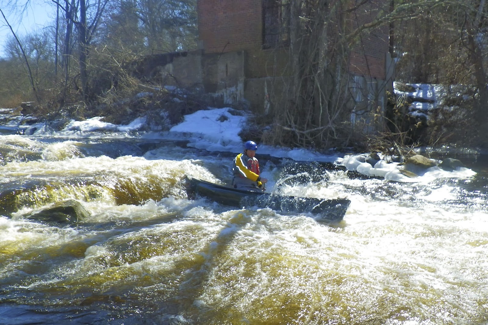
We met at the Richmond Dam at 10:30 and ran the shuttle up to Shannock .  There is a new put-in on Railroad Street below the Lower Shannock Falls that allows you to skip the reconstructed rapids, but we went up to the old put-in in Shannock Village.  Duke gracefully slid into the water, headed over to a wave below the Horseshoe Falls, and promptly flipped into the icy water.  He rolled up a few seconds later, but I remember thinking that the water must be cold.  It would be my turn to find out soon enough.

Yup - I took on a little water -
photo by Tommy Taylor
We headed downstream to run the Lower Shannock Falls.  Jim didn’t have his drysuit, so he decided to line his boat on the right side.  The boat ended up swamping at the bottom of the rapid, but Jim was happy because he stayed dry. 

The rest of us ran the falls pretty much down the middle.  The big rock that use to be at the bottom of the rapid to provide a rest eddy for fish travelling up stream has been removed, so it’s actually a pretty easy run.  The solo boats definitely took in some water at the bottom, but the big tandem that Jeff was paddling ran it dry. 

Duke in the Carolina Raceway
While Jim was bailing out his boat, I decided to do some surfing in the wave at the bottom of the rapid.  It didn’t take me long to get swung sideways and flip as I tried to sidesurf.  Yup – that water is COLD!  Tommy did a nice boat-over-boat recovery to get me back in my boat, and we were soon on our way again. 

The river was flatwater until reached the Route 112 Bridge and entered the old Carolina Mill raceway.  At this level, the raceway was quickwater with a couple of small waves and a couple of rocks to dodge.

Downstream from the raceway is the Carolina Canoe Campsite where we stopped for lunch.  Jim got a nice fire going, and we had a good time trading war stories.  From there it’s only a mile or so down to the Richmond Dam.  We ran the dam and did a little surfing before packing up and enjoying some pizza nearby.  As always, a great day.

Surfing below the Richmond Dam - photo by Tommy Taylor
Links:

Monday, December 27, 2010

Pawcatuck – Shannock to Richmond – December 26th

We were originally talking about going to T’ville yesterday, but with a snowstorm approaching, we decided to stay local instead. At Jim’s suggestion, we ended up padding the Pawcatuck River from Shannock to Richmond. This is a section that I hadn’t done before, so it sounded good to me.

I met Jeff and Jim at the Richmond Fishing Area around 9:00 and we ran the shuttle up to Shannock. The run is about 4 miles long and has a little bit of everything – flatwater, quickwater and a few easy rapids. The level was low but fluid – 100 cfs, 2’ on the Wood River Junction gage; 75 cfs, 1’ on the Kenyon gage. Snow was just starting to fall as we reached the put in.

Just downstream from the put-in in the Shannock Village are the rapids of the reconstructed lower Shannock Falls. A 2’ drop at the end of the rapids would be fun if it wasn't for a large boulder placed in the middle of the river just downstream. This boulder was supposedly placed there to provide a rest eddy for the fish, but I suspect more than a few boats will get pinned on it. Due to the low water, and the mid-stream boulder, we decided to line this section.

The next mile is flatwater leading to the Route 122 bridge and the easy rapids in the old Carolina Mill Raceway. We did two runs through the raceway, and then began picking our way through the blow downs until we reached the Carolina Canoe Campsite. As we took a break, Jim lit a small fireplace – a nice treat on a snowy day. Its amazing how much heat a small fire can produce.

The snow was falling heavily by the time we got back on the river. We headed down to the Richmond Fishing Area where we ran the dam and did a little surfing in the playspot. By this time, the roads were starting to look bad, so we loaded up the boats and headed home to sit out the storm.


Links:
My Pictures
Trip Description from Rhode Island Blueways
Richmond Fishing Area from Google Maps
Kenyon Gage
Wood River Junction Gage