Showing posts with label ME. Show all posts

Monday, May 25, 2026

Upper West Branch of the Penobscot/Lobster Lake - May 19-24, 2026

Checking in at Telos Checkpoint
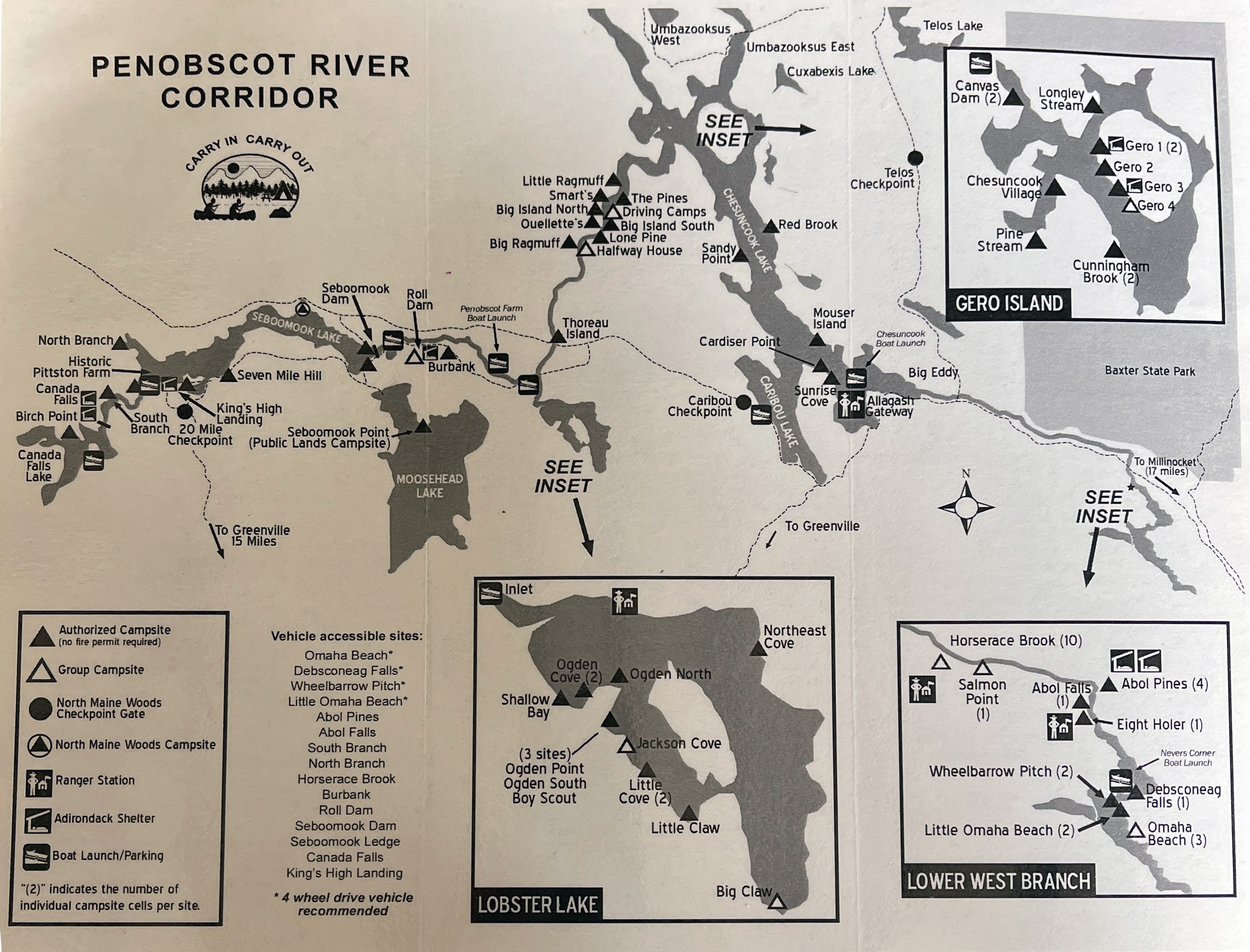
Back in March, Jonathan and I started planning our spring camping trip. We decided on a Maine classic – the Upper West Branch of the Penobscot. Unfortunately, Jonathan had to bow out due to family obligations, but Bill, Aaron, Matt and I had a great time on the trip. I paddled tandem with Bill in my Spirit II.

The Penobscot River drains much of vast wilderness area known as the North Maine Woods. With is four branches (North, South, East and West), the Penobscot is the second largest river system in Maine (behind the St. John) and the longest entirely in the state. The North Branch and South Branch converge to form the West Branch at Seeboomic Lake. The West Branch and East Branch converge in Medway to form the main stem of the Penobscot

Paddling down Lobster Stream
There is a popular whitewater run on the Upper West Branch from Seboomook Dam to the Roll Dam, but the classic canoe camping trip  is to put in below Roll Dam and paddle about 7-miles to Lobster Lake. After a night or two on Lobster Lake, paddle 15-miles to Chesuncook Lake, and then 19-miles down the lake enjoying the great views of Mount Katahdin to the east.

We didn't do anything that ambitious. We put in at Lobster Stream and took out at Umbazooksus West on the northeast corner of Chesuncook Lake - 5 days, 4 nights with a stop at Lobster Lake.

Sandy beach at Ogden Point Campsite
We met on Tuesday night at Matt’s house on Cousin’s Island in Yarmouth, ME. Matt treated us to a great chili dinner, and we enjoyed the great views of Casco Bay until it was time for bed.

We were up early on Wednesday for the drive to Northwoods Outfitters in Greenville for the shuttle. We had our boats and gear loaded by 9:00, and we were on our way. It was a 3-hour drive to Lobster Stream on dusty, dirt logging roads. After unloading our gear and a quick break for lunch we were on our way down Lobster Stream to our first campsite - Ogden Cove on Lobster Lake.

Paddling down the Penobscot River
As its name suggests, Lobster Lake is shaped like a giant lobster claw. It is known for its white sand beaches and great mountain views. The wind was out of the northwest as we began our crossing from Lobster Stream toward Ogden Point, giving us a tricky tail wind. Everyone arrived fine, and we begin setting up camp and gathering fire wood.

The winds continued to pick up over the afternoon, with significant gusts in the late afternoon and early evening. We found whatever shelter we could, and had to rebuild the firepit with a larger wind screen in the back before lighting a fire. We cooked dinner, enjoyed a beautiful sunset and sat around the fire until around 10:00 when we called it a night. Total paddling for day 1 – about 3-miles.

Pine Steam Campsite
The winds were still blowing when we got up on Thursday. The original plan was to take a lay-over day to explore Lobster Lake, and perhaps hike up Lobster Mountain, but we were concerned about winds forecasted for the next few days. Instead, we decided to head back to the river while the wind was still manageable. With the decision made, we packed up camp and were crossing back over Lobster Lake into a strong headwind by 9:00.

Once again, everyone crossed with no problem. We took a quick break at the Lobster Stream put-in before continuing down the Penobscot River. Our objective was to get to the campsite at Pine Stream, which is one of the most popular on the river. We passed numerous empty sites along the way, and we were surprised that there weren’t more people on the river on the lead-up to Memorial Day weekend.

Exploring Pine Stream
The river is mostly flatwater, with the exception of some easy rapids along Big Island. Unfortunately, Bill and I ran up on a rock and dumped into the river. I was able to grab the boat, get it turned over (good thing everything was strapped in), and wade it over to shore. Bill had a little rougher time on the slippery rocks, but he eventually got to shore and into some dry cloths.

We were back on our way, and made it to Pine Stream at around 3:00. We set up camp, gathered wood, prepared diner, and enjoyed another amazing sunset. After the long paddle, much of it against the wind, I was in bed early – around 9:00. Total paddling for day 2 – around 18-miles.

Gero Island 1 Campsite
Friday was a lay-over day so we slept late, enjoyed a nice breakfast and took it easy napping (Matt and Bill), reading (me) and painting (Aaron) until around 2:00 when we headed out to paddle Pine Stream, a slow moving tributary of the West Branch. It started off as woodlands, and eventually became a large marshland. After about 5-miles a blowdown blocked our way, so we decided to turn around and head back to the campsite.

Back in camp we cooked dinner and apple crisp for dessert in the reflector oven. We enjoyed another great sunset before heading off to bed. Total paddling for day 3 - around 10-miles.

View of Mount Katahdin
The wind was calm when we got up on Saturday. We prepared breakfast and headed off for the short trip to Chesuncook Lake. When we arrived at Chesuncook, the lake was calm and we crossed over to campsite 1 on Gero Island. We set up camp, had lunch and did a second afternoon paddle to a pretty cove on the northeast corner of Chesuncook with great views of Mount Katahdin. Back in camp we cooked dinner, and Matt baked orange-cranberry scones for dessert in the reflector oven. We enjoyed and other great sunset before heading off to bed. Total paddling for day 4 - around 10-miles.

We got up early on Sunday for the short trip to Umbazooksus West to meet the shuttle. We arrived around 10:00, and the shuttle arrived around 10:30. We were back in Greenville at around 2:00 and got on the road after a quick lunch. Total paddling for day 5 – about 5-miles. No rain on the trip, but it poured on the way home – that’s the way it should be.


Links:

Sunday, March 1, 2026

Planning for Spring Camping - West Branch of the Penobscot/Lobster Lake

Back in February I got an email from Jonathan looking to start planning a spring camping trip. We decided on a Maine classic - the West Branch of the Penobscot in May. Unfortunately Jonathan has now dropped out due to family obligations, but the trip is still on. 

The classic trip is to put in below Roll Dam and paddle about 7-miles to Lobster Lake. After a night or two on Lobster Lake, paddle 15-miles to Lake Chesuncook and then 19-miles down the lake enjoying the great views of Mount Katahdin. 

We are not planning anything that ambitious - 5 days, 4 nights with a leisurely pace. For the shuttle, we will use North Woods Outfitters (NWO) in Greenville. They will drop us at Lobster Stream, and pick us up at Umbazooksus West. Here is the plan:
  • Tuesday, May 19th - assemble somewhere close to Greenville.
  • Wednesday, May 20th - get to NWO early - 8:00 a.m. to 9:00 a.m. NWO drives us to Lobster Stream (45.89223,-69.56466), which will take 2 – 3 hours. Paddle to Lobster Lake - camp at Ogden Cove camp site (45.857293,-69.54895) – 3-miles.
  • Thursday, May 21st – explore Lobster Lake and hike up Lobster Mountain - trailhead is near Jackson Cove (45.851017,-69.542996).
  • Friday, May 22nd – paddle half way up the river to somewhere around Lone Pine (45.997846,-69.49727) – 12-miles.  There are lots of sites in that area to choose from.
  • Saturday, May 23rd - finish paddling the river and across the top of Chesuncook Lake to one of the sites on Gero Island like Gero 3 (46.063178,-69.386223) – 11-miles.
  • Sunday, May 24th – paddle to Umbazooksus West (46.1302,-69.3687) – 5-miles. NWO picks us up at approximately 11:00 a.m. and drives up back to Greenville to pick up our cars. Load vehicles and head home.
For food, everyone will bring their own. It will make the logistics and packing a lot easier. In terms of boats, I’ll paddle tandem with Bill and plan to bring my Spirit II. 

Monday, September 15, 2025

Allagash - September 8-13, 2025

Ready to head out from Wiscassrt
Every paddling trip is an adventure, and this one was no exception. Jonathan, Bill, Dan and I accepted the challenge of bad roads, blown tires and low water, and had a great trip on the Allagash. We ran the section from Churchill Dam to Michaud Farm with a day to explore Churchill Lake.

The State of Maine established the Allagash Wilderness Waterway in 1966 to preserve this unique section of the North Maine Woods. It is a 92.5-mile state park along the Allagash River that begins at Telos Lake and ends in Allagash Village. It is also one of the original "Wild and Scenic" rivers. While surrounded by commercial woodlands, logging is prohibited within 1-mile of the river. It can be reached only by traveling for miles on dirt logging roads.

Campsite at The Jaws
We met at Jonathan’s house in Wiscasset on Sunday to load the boats and consolidate our gear. On Monday morning we were up early and heading north. We made a quick stop at Dunkin Donuts in Augusta for breakfast. As I was drinking my coffee in the parking lot, I noticed a screw in my passenger side rear tire. That meant a stop at Tire Warehouse for a repair before we moved on.

We got back on the road at around 10:30 and headed north to Greenville. We stopped at the Indian Hill Trading Post for sandwiches before starting our trip down 90-miles of dirt logging roads to the put-in. We stopped for lunch at the Cribworks on the West Branch of the Penobscot, registered at the Telos Checkpoint, and then continued on to Churchill Dam. We managed fine until we reached the road down to the dam – McCluskey Brook Road. It was filled with huge ruts and pot holes. About a mile from the dam I blew out my driver’s side rear tire. Fortunately, I had a real spare tire in addition to the donut. We got it changed and continued down to the dam.

Running Chase Rapid
At the dam we checked in with the ranger, packed up the boats and headed off to our first campsite – The Jaws. It was late and we debated staying at the dam, but Jonathan’s 1-hp trolling motor (the "put-put") made quick work of the crossing. The campsite was open and we got to work unloading the boats, setting up camp, and gathering firewood. Dinner was Jonathan’s Fried Fish and Maine Guide Potatoes. It was a chilly night, but we all sat around the fire until 10:00.

On Tuesday we planned to motor down to Eagle Lake to see the trains and tramway, so we had an early breakfast and headed out. It was calm as we started, but the wind was picking up as we got to John’s Bridge at the end of Churchill Lake. Its a 20-mile round trip, so we decided not to chance it. We turned around and stopped at Scofield Point for lunch on the way back to camp.

Crossing Umsaskis Lake
We were back in camp in the early afternoon, so we decided to walk down to the dam to check out the Churchill Depot History Center Museum. We were back in camp again in time for our sunset G&T’s and dinner - Jonathan's pan-fried salmon. We sat around the fire and enjoyed the stars until it was time for bed.

It was a chilly morning on Wednesday as we were to begin our trip down the river. Dan brought a bunch of fresh peaches that he got from a neighbor, so we made blueberry-peach french toast bake in the Dutch oven for breakfast. Then we packed up camp and headed back to Churchill Dam to run the Chase Rapids. We met the Ranger at the dam who shuttled our gear down to Bissonette Bridge so we could run the rapids empty.

Sitting around the breakfast fire
Chase Rapids is a short set of class II rapids just below the dam. Water level is controlled at the dam, and it generally runs around 500 cfs. After the rapids, the river alternates between quickwater and class I rapids. Everyone made it through fine.

We collected our gear at Bissonette Bridge and continued downstream to Chisholm Brook for lunch. From there, it is a short paddle down the river, and an easy trip with the put-put motor across Umsaskis Lake and into Long Lake. Our campsite for the evening was Grey Brook. We had planned to camp across Long Lake at Jalbert, but another group beaten us to it.

Clouds over Long Lake
We settled into our familiar routine – unload the boats, set up camp and gather fire wood. Dinner was Dan’s gnocchi with zucchini and pesto. We were all tired, but still managed to sit around the fire until around 9:00.

It was another chilly morning on Thursday as we got up to light the fire and start the coffee. After breakfast we packed up the boats for the trip down to Round Pond. Jonathan’s putt-putt motor made quick work of the remaining section of Long Lake.

Passing the American Elms
At the bottom of Long Lake is the Long Lake Dam. Due to metal spikes in old timbers it is recommended that you portage on the right. We portage all the gear and Jonathan’s Explorer, but Bill ran the Penobscot 17 down the left side and made it through fine.

We were paddling into a strong headwind below Long Lake. It was a bit of a slog, but we continued downstream and stopped at Sweeney Brook for lunch. Before long, we paddled under the Henderson Bridge, past the American Elm trees and into Round Pond.

Heading out from Round Pond
Our campsite for the night was Outlet. We would have preferred Inlet, but once again it was taken. The firewood crew went to work collecting and cutting wood for the night. Dinner was steak tips and scalloped potatoes. We sat around the fire until 9:00, then called it an early night.

Dan was up early on Friday to light the fire and start the coffee. I rolled out of the tent at around 6:15. Breakfast was pancakes and home fries in the Big Daddy skillet, and we were soon packing up our gear and heading out.

Visiting the Lombard Log Haulers
We paddled out of Round Pond into the Round Pond Rips, which were low and scratchy at around 450 cfs. We were out of the boats often to wade through the shallows. Eventually, we arrived at the Musquacook Deadwater where we fired up the put-put motor for the trip down to Five Fingers Brook. We stopped for lunch at Bass Brook, and stopped at Cunliffe Depot to see the Lombard Log Haulers.

From there it was a quick run-down to our campsite for the night at Ramsay Ledge. We were hoping for Cunliffe Depot, but the same group of paddlers beat us there again. Maybe it was just as well. Ramsay Ledge was a bigger site with with grass and lots of sunshine. Dinner was hot dogs and beans. We enjoyed the fire one last time before tuning in for the night.

The take out at Michaud Fram
On Saturday, we needed to be down to Michuad Farm by 9:00 to meet Norm L’Italien from Pelletier's Campground for the shuttle back to our cars. Since my good spare was already on the car, we decided to head out by a shorter route through the Six Mile Checkpoint in Ashland.

About 10-miles in to the 50-mile trip over dirt logging roads, I blew another tire. This time, I had to put on the donut. 
We drove 40-miles at 10-miles per hour hoping the donut would last. It did, but by then it was too late to get the tire fixed. We ran the donut another 100-miles on the highway to get to Jonathan's house in Wiscasset. The "little donut that could" pulled us through. I was able to get a new tire on Sunday morning, and headed home.

Thursday, August 14, 2025

Planning another Allagash trip

I'm planning another Allagash trip with Jonathan in September - this time with Bill and Dan. As usual, we'll do five nights on the river with a spare/layover day to explore the lakes. Here’s the schedule:
  • Sunday, September 7th - assemble at Jonathan’s in Wiscasset in time for dinner.
  • Monday, September 8th – leave Wiscasset early for the 5-hour drive to Churchill Dam - camp at the Jaws.
  • Tuesday, September 9th - spare day to explore the lakes – another night at the Jaws. I would love to get down to Eagle Lake to see the trains and tramway if the putt-putt engine is working - 20-mile round trip.
  • Wednesday, September 10th – run Chase Rapids - camp at the Ledges on Umsaskis or Jalberts on Long Lake.
  • Thursday, September 11th - Long Lake Dam (portage) - camp at Inlet or Outlet on Round Pond.
  • Friday, September 12th - Round Pond to Five Finger Brook - camp at Five Finger Brook or Cunliffe Depot. I wouldn’t mind seeing the log haulers at Cunliffe Depot again.
  • Saturday, September 13th – early start down to Michaud Farm to meet Norm L’Italien (Pelletier’s Campground) for the ride back to Churchill Dam. Drive back to Wiscasset for dinner, or the long drive home.
We'll paddle tandem in Jonathan's Explorers. We’ll bring coolers with real food for as long as possible. Lunches and drinks are BYO. Jonathan will bring cooking gear and G&T for the 6:30 sundown meeting. Everyone will bring their own chair, camping gear, coffee mug, and other refreshments. We'll have to figure out who’s doing what for meals, and the remaining group gear.

The last time we were there the river was between 2,500 and 3,000 cfs. Today it is at 451 cfs - about what it was when we were there in 2022

Hopefully they will get some rain.

Monday, August 11, 2025

Dead - Spencer Stream to West Forks - August 9, 2025

The boats get loaded
There are rivers that aren’t too difficult if you take the right lines, but can be brutal if you don’t. I was on one of these rivers on Saturday – the Dead in ME, and I paid the price for a bad line on the last rapid - Lower Poplar. My first swim of the year.

The Dead is one of the longest continuous whitewater runs in the Northeast with approximately thirty rapids along a fourteen-mile stretch. The river is mostly boulder-type rapids with lots of holes and pour-overs. The shoreline has thick vegetation that grows right up to the river's edge that can make it difficult to rescue swimmers or bail out an open boat. The major named rapids are:
  • Spencer Rips –big weaves are to the right, big eddy below on left to stop and regroup.
  • Minefield (2 miles) – long boulder garden with big waves and lots of holes – difficulty increases where the river turns left.
  • Hyden’s – (3 miles) good lunch spot – run in middle and stay out of holes.
  • Gravel Pit (4.5 miles)
  • Enchanted Stream (7 miles) – another good lunch spot.
  • Elephant Rock – (7.5 miles) a river wide ledge immediately below Enchanted Stream. You can run the big waves in the center, or the slot on the right between Elephant Rock and the rock wall.
  • Mile Long (8.5 miles) – another long boulder garden with big waves and lots of holes. There is an eddy on the left about half-way down
  • Upper Spruce Ledge (10.5 miles)
  • Lower Spruce Ledge (11 miles)
  • Upper Poplar Falls (11.5 miles) – short but intense rapid filled with rocks and holes. Go right and stay away from holes – stop in big eddy bottom right.
  • Lower Poplar Falls (12 miles) – a longer intense rapid that tumbles down the left side in huge wave trains and large holes. Left is hero line with lots of dangerous holes. The right line along the boulder garden is the usual open boat route.
Heading out
I picked up Paul for the six hour drive up to the Forks. We stayed in a two-person cabin-tent at Northern Outdoors. We had a small fire on Friday before settling in for the night.

We were up early Saturday morning to meet our group and the shuttle. We were paddling with the Penobscot Paddle and Chowder Society - aka the Chowder Heads. We had a group with 13 boats – 6 canoes, 6 kayaks and 1 shredder.

Charlie in one of the unnamed rapids
Old-time Dead River paddlers probably remember Webb’s Shuttle Service run by Ed Webb. Webb's (later Riverdrivers) no longer provides shuttle service, so we met the new shuttle company - Ironbound Outdoors - at 8:00 at the Public Takeout on Dead River Roar in West Forks.

With the large group of MVP'ers running the Dead for a step-up weekend, it took forever to load the boats. We finally got on the road around 9:30, and got to the river about 45 minutes later after a long, bumpy, dusty trip down 20-miles of dirt logging roads. We finally got on the water around 11:00.

Paul running Lower Poplar
The release was supposed to be 2,400 cfs, but was closer to 2,100 cfs with 25 cfs from Spencer Stream - a nice class II/III. At lower levels (1,200 cfs to 1,800 cfs) it is primarily class II except for the very first, and last couple of rapids. At medium levels (2,000 cfs to 3,500 cfs) it is mostly class III. At higher levels (4,500 cfs to–8,000 cfs) it is class IV.

We ran through Spencer Rips, Minefield and some other unnamed rapids before stopping for lunch at Hayden's. Then we ran Hayden's, Gravel Pit and some other unnamed rapids before taking a break at Enchanted Stream. Paul wanted to get some video so I ran the big waves in the middle of the ledge at Elephant Rock rather than the shoot on the right.

Erik running Lower Poplar
The next major rapid was Mile Long – another long boulder garden with big waves and lots of holes I filled my boat about half way down, but was able to empty it in a big eddy on the left before finishing the rapid. After running the Upper and Lower Spruce Ledges we took a break at the Poplar Portage Trail before taking on Upper and Lower Poplar.

Upper Poplar is a short but intense rapid filled with rocks and holes. Most of us ran it to the right and made it through fine. Lower Poplar was another story. The river turns right along a boulder garden as the water tumbles down the left side in huge wave trains and large holes.

Swimming Lower Poplar
Most of the open boats took the right line along the seam between the boulder garden and the big holes. As I was coming down I saw Charlie flip in front of me. I got around him to the left, but now I was  out in the big holes and pour-overs. Before long, my boat was full of water and I was struggling to keep it upright, never mind avoiding the rocks and holes. About half way down, I went sideways over a large rock into a hole, and over I went.

As I swam downstream I looked back to see my canoe still stuck in the hole. That was the least of my problems. Swimming through rapids is something that I try to practice, but it doesn’t match the real experience. First, I swam though a series of “haystacks” or standing waves where you have to breathe in the trough, and hold your breath as you go through the wave - breathe, glug, breathe, glug, breathe, glug.

Reunited with my boat at
the bottom of Lower Poplar
After the waves, I could see a horizon line downstream indicating that I was approaching a rock with a hole on the other side. I tucked into a ball as best I could as I went into the hole. When I came out the other side Paul was yelling at me to swim hard to the left shore since I was approaching another big hole. I wasn’t making much progress so I threw away my paddle thinking that would allow me to swim better. After more waves, rocks and holes, I finally got myself to shore. It was about a 200-yard swim, but it seemed like forever.

After I caught my breath I looked over and could see Paul on the other side of the river with my boat. I hiked downstream and was about to jump in the shredder for a ride to the other side when Craig paddled over towing my boat. I had paddled through 30 rapids over 14-miles only to swim the last 200-yards. We had 3 other open boaters swim Lower Poplar, so I guess I shouldn't feel too bad. 


The swim earned me a new poem from Tom.

It’s really not an Outrage,
until one’s stood on end.
But chill we will baptised beginning,
again, again, again.

If that ol’ paddler’s adage, “Ya ain’t really learnin’ unless yer gettin’ wet,” holds any water, we’re gonna have t’call ya, Doctor Dunk, Erik.

Man’s gotta do what a man’s gotta do.
TW

Friday, May 23, 2025

Baskehegan Stream - May 17-21, 2025

The crew - loaded up and ready to go
The forecast called for rain on Saturday, and Sunday, and Monday and Tuesday, but it didn’t matter. This trip on the Baskehegan had been on the calendar since March, so we weren’t going to miss it no matter what the weather.

Baskehegan Stream arises in Carroll, ME and flows generally north for around 40-miles to Bancroft where it joins the Mattawamkeag River. We would be paddling the section through Baskehegan Lake from White Farm Road in Topsfield to the dam in Danforth. Originally, the plan was to paddle down to the bridge in Bancroft, but more on that later.

Put in on White Farm Road
We met at Jonathan’s in Wiscasset Friday night so we could get an early start Saturday morning. There was a steady drizzle on Saturday as we loaded the boats and gear and headed out. It was about a 3-hour drive from Jonathan’s house to the river, about 6.5-hours from my house in Woonsocket.

White Farm Road is a dirt logging road owned by a local logging company. The put in is just below a bridge and a pretty waterfall. After unloading our boats and gear we ran the shuttle up to Bancroft. We finally got on the water at around 4:00.

Wading through the shallows
This first section of the river tends to be shallow. With recent rains, we hoped the river would be up, but it wasn’t. We frequently ran aground and had to get out to wade our heavily loaded boats. Fortunately, it was a short trip down to the first campsite – Upper Baskahegan Campsite. Day 1 paddling – about 2 miles.

We unloaded our gear and quickly got the tarp and tents set up. We gathered wood as Jonathan prepared dinner – his classic fried fish with Maine guide potatoes. After dinner we sat around the fire until 9:45 when we called it a night.

Beaver lodge in the Big Bog
There is something to be said for staying warm and dry inside your tent as the rain is falling outside. I woke up at 6:00, but with the rain I didn’t crawl out of my tent until around 7:30 when I heard Conrad making coffee. The rain was expected to fall until noon, so we had a soggy breakfast and packed up a soggy camp.

We got on the water around 11:00 for our trip through Big Bog – the large wetland that feeds Baskehegan Lake. There were beaver lodges everywhere, but surprisingly few birds or other wildlife. The river twisted and turned through a marsh with very little solid ground. We took a break for lunch in our boats.

Crossing to Long Island
We arrived at Baskehegan Lake and found it flat and calm. Fog was rolling in and out as made the crossing to the Long Island Campsite. Day 2 paddling – about 9-miles.

The rain and fog continued as we set up camp. By 6:00, tents and tarps were up, and wood was gathered. Time for cocktails. Dinner was Ellen’s chili, and desert was Jules’ brownies. It was another early night. I was in the tent around 9:30.

Tents with extra tarps for the rain
I woke up at 2:30 to a torrential downpour. Everything was dry in my tent, so I fell back asleep and woke up around 5:00 to rain and gusting winds. The plan was to get an early start, but it didn’t look like that was going to happen, so I went back to sleep. I woke up again at 7:00 to another torrential downpour.

I finally crawled out of my tent around 7:30 when I heard Jonathan lighting the fire and making coffee. We cooked breakfast and started taking down camp in the rain. We finally got on the water at around 11:00. This was to be our biggest paddling day – around 12-miles down to the Narrows Campsite on Crooked Brook Flowage. We would be paddling into 10-mph headwinds with gusts around 25-mph.

Crossing to Round Island
We launched and headed out on the crossing to Round Island – about 1/2-mile. The going was slow, and the wind was kicking up small waves, but everyone made it across fine. From there, we did another 1/2-mile crossing from Round Island to North Point. Once again, it was a slow crossing, but everyone made it across fine. Finally, we had to paddle about a mile along the shore to the outlet for Baskehegan Stream.

We ran the broken dam as we left the lake and reentered the river. We continued to fight a strong headwind as the river twisted and turned thorough another large wetland. We were cold and tired when we pulled into the Anvil Meadows Campsite for a break at around 3:00. Rather than paddling on, we decided to call it a day. Day 3 paddling – about 8 miles, about 4 miles short of our goal.

Tarp is up at Anvil Meadows
With the decision made to stay, we got to work setting up camp and gathering wood. I was the chef for the evening and made lasagna in the Dutch oven. Everyone was tired, and we were in the tents even earlier – a little after 9:00.

Tuesday was the first morning that the rain didn’t keep me in the tent. I got up around 6:00, started the fire and the coffee, and started taking down my tent. With the truncated day on Monday, we knew that we needed to get an early start today. We had a quick breakfast, broke down camp and loaded the boats for the final leg of our trip. We are on the water at around 8:30.

Running the small rapids
This section of the river was a lot of fun with short sections of flatwater separated by quickwater and easy rapids. We took turns picking lines through the rapids. Eventually, we reached Crooked Brook Flowage, which is the dead water above the Danforth Dam. We passed the Narrows camp site – our intended campsite from the day before.

We crossed the flowage, and paddled along the shore down to the Danforth Dam into a 15-mph headwind with gusts around 30-mph. It was a real slog. We pulled into the boat ramp at around noon. Day 3 paddling – around 7-miles.

Take out at Danforth Dam
It was clear that we didn’t have time to do the portage and 7-mile trip down to Bancroft, so we needed to get a ride back to our cars. Fortunately, there was a guy sitting in his truck in the parking lot. We struck up a conversation and he offered to give Jonathan a ride - problem solved.

This trip was definitely a case of Type 2 Fun. It was cold, cloudy, windy and rainy. We spent most of our time cold and wet. We were paddling heavily-loaded boats through shallow water and against strong headwinds. But in the end, we pulled together and made it work. We only paddled 26-miles total, but the camping and comradery was still great.

Thursday, March 27, 2025

Planning for Spring Camping - Baskaheagan Stream

There’s finally a camping trip in the works. I only did a couple of overnight trips last year, and work is making it tough again this year, but we now have a spring trip on the calendar - the Baskaheagan in Maine.

Jonathan described this trip as an undiscovered gem with numerous campsites that allow for an easy 3 or 4 night trip. It’s mostly flatwater and lakes, but very pretty and remote. The trip is dependent on water levels and can typically be paddled from early May to early June, and in the fall when the water level is sufficient.

Based on Jonathan’s experience last year we can expect a somewhat boney run to the first campsite on the river. Then river/lake to the first island campsite. Then lake and quickwater to the second campsite. After that there is a short carry around the dam in Danforth followed by some class I/quickwater to the takeout above a class III pitch.

Here is the plan:
  • May 16th – we all gather at Jonathan’s in Wiscasset.
  • May 17th – pack up for the drive up to the White Farm Road put-in in Topsfield. Run the shuttle, and then paddle down to the Upper Baskaheagan Campsite for the night - 1.5 miles.
  • May 18th – continue down Baskaheagan Stream to Baskaheagan Lake. Camp at either the Long Island or Round Island Campsites – 9-miles not including any exploration of the lake.
  • May 19th – continue across Baskaheagan Lake and renter Baskaheagan Stream. Camp at the Narrows Campsite near Crooked Brook Flowage – 12 miles.
  • May 20th – continue down Baskaheagan Stream to the take-out at 2000 Road in Bancroft with a portage of the dam in Danforth – 10 miles. Pack up and drive back to Wiscasset for the night.
  • May 21st – get up early and drive home.
So far the group is me, Jonathan, Conrad, Ellen, and Jules. Should be a lot of fun. Here's hoping for water, nice weather, and not too many bugs.


Saturday, September 30, 2023

Back to the Alligash - September 22 - 30, 2023

Loaded up and ready to go
Getting ready to go on a trip is always hectic, but this time it was particularly so with family stuff, work, and of course packing. When Bob arrived to pick me up on Friday afternoon I turned off my computer, picked up my bags and headed out. Hopefully I had everything.

This would be my second trip on the Allagash Wilderness Waterway with Jonathan and Conrad. For this trip we would be joined by Bob and Ellen. We would be running the river from Churchill Dam to Michaud Farm with a layover day that we used to explore Churchill Lake.

We made it to Fort Kent
The State of Maine established the Allagash Wilderness Waterway in 1966 to preserve this unique section of the North Maine Woods. It is a 92.5-mile state park along the Allagash River that begins at Telos Lake and ends in Allagash Village. It is also one of the original "Wild and Scenic" rivers. While surrounded by commercial woodlands, logging is prohibited within 1-mile of the river. It can be reached only by traveling for miles on dirt logging roads.

We arrived at Jonathan’s house in Wiscasset around 5:30 and enjoyed cocktails on the deck until Conrad and Ellen arrived at 7:00. Dinner was the traditional sausage and noodles. We turned in early to be rested-up for the big trip.

Norm loading the boats
We got up early on Saturday, loaded up the boats and gear, and headed off to Fort Kent. After a quick stop at D&D in Augusta, we settled in for the 3-hour drive to Patten, ME and lunch at Craig’s Claim Shack. Unfortunately, it was closed for the season – we missed it by a week. The back-up was Debbie’s Deli, which worked out fine. From there, it is another 2-hours to Fort Kent.

We arrived at Fort Kent and checked-in at Northern Door Motel for the night. We had some time before dinner so we took a walk around Fort Kent, which has a border crossing to Canada across the St John’s River. We also checked out the Fort Kent Blockhouse – built during the Aroostook War of 1838-1839. The day ended with dinner at Swamp Buck.

Crossing Churchill Lake
We were up early on Sunday to meet Norm at Pelletier’s Campground for the shuttle. We would be dropping off our cars at Michaud Farm (about 10-miles), and continuing down to Churchill Dam (about 70-miles). It's a 3-hour ride down dirt logging roads, but at least we were not driving our cars.

After arriving at Churchill Dam we checked in with the ranger, packed up the boats and headed off to our first campsite – The Jaws. Surprisingly, everything fit in the boats and Jonathan’s putt-putt engine made quick work of the crossing. The campsite was open and we got to work unloading the boats, setting up camp, and gathering firewood. Dinner was Jonatan’s Fried Fish and Maine Guide Potatoes. We sat around the fire until it was time for bed.

Checking the flow at Churchill Dam
Winds were predicted to gust to 20 mph on Monday, so we decided to take our layover day. With nowhere to go, I cooked breakfast in the Dutch Oven – Blueberry Bake with a side of bacon. Later in the morning, we took a walk down to the Churchill Dam to check out the release from the dam and the Churchill Depot History Center museum that is located nearby.

After hiking back, we had lunch and spent some time gathering firewood before taking a quick tour around Churchill Lake. Jonathan and Bob wanted to catch a fish, and Ellen wanted to see a moose, but neither were successful. We were back in time for cocktails and to cook dinner. It was my turn to cook and I made lasagna in the Dutch Oven with sausage on the side. I played a game of cribbage with Bob (I lost) and we sat around the fire and enjoyed the stars.

Home fries for breakfast at the Jaws
One thing you learn when you are camping is patience. I rolled out of my tent at around 6:00 on Tuesday to start the fire and the coffee. I sat in front of the fire and waited for the coffee to perk. Jonathan got up at around 6:15, and we sat in front of the fire and waited for the coffee to perk. Conrad got up at around 6:30, and we sat in front of the fire and waited for the coffee to perk. The coffee finally started perking at around 6:45 and we had our coffee at around 7:00 - it was worth the wait.

Jonathan was on for breakfast, and he cooked home fried potatoes from the left-over Maine Guide Potatoes and eggs-in-a-hole – a traditional breakfast for this trip. We packed up camp and headed back to the dam to meet the ranger at 10:00 for the shuttle around the Chase Rapids. For $10, the ranger with shuttle boats, gear and people down to Bissonette Bridge. Jonathan Bob and I would be running Chase Rapids. Conrad and Ellen took the shuttle.

Running Chase Rapid
Chase Rapids is about 2-miles of class I/II whitewater. Jonathan and I ran it tandem in his Explorer. Bob poled it in his Camper. The first rapid bounces down a 200-yard rock garden. The second is a rocky S-turn, and Jonathan and I got hung up on the rocks about half-way down. Bob ran it clean. From there, the river alternates between quickwater and class I rapids. It was a fun run, and we soon met up again with Conrad and Ellen at Bissonette Bridge for lunch.

After lunch, we loaded up the boats for the trip down the river, across Umsaskis and into Long Lake. Jonathan’s putt-putt motor made quick work of the crossings and we were soon at our campsite for the evening – Jalbert. We settled into our familiar routine – unload the boats, set up camp and gather fire wood. Dinner was Conrad’s smoked salmon with grilled vegies. We were all tired and were in bed by around 9:00, except Jonathan who always stays up later.

Frittata for breakfast at Jalbert
It was a foggy morning on Wednesday as I got up to light the fire and start the coffee. I was up for breakfast, so I made potato, onion, pepper and cheese frittata in the Dutch Oven. After breakfast we packed up the boats for the trip down to Round Pond. Jonathan’s putt-putt motor made quick work of the remaining section of Long Lake.

At the bottom of Long Lake is the Long Lake Dam. Due to metal spikes in old timbers it is recommended that you line on the left or portage on the right. Due to high water, there was really no place to land on the left, so we decided to portage. Its a short portage, and we made quick work of it in spite of all the gear.

Entering Round Pond
Just as we finished, an unnamed poler (name withheld to protect the innocent) approached the dam. After a long look, he also decided to portage. After emptying his boat and looking from above he changed his mind. He poled the shoot on the left in an empty boat and made it through fine. It was probably good that we didn’t see that before we lugged our boats.

We continued downstream and stopped at Cunliffe Island for lunch. The level was high (between 2,500 and 3,000 cfs.) and the river was mostly slow moving water. It was still a quick trip, and before we knew it we ran past the American Elm trees, under the Henderson Bridge and into Round Pond. Our campsite for the night was Inlet, and we unloaded the boats and set up camp. Jonathan went off to replenish our water supply at the spring while the firewood crew went to work collecting and cutting wood for the night. Dinner was Ellen’s Magic Chili. It was another early night.

Running Round Pond Rips
I woke up at 5:30 on Thursday to the sound of a Bard Owl somewhere near our camp – “who-cooks-for-you, who-cooks-for-you-all”. It reminded me of the time at an owl parked himself over Jim Cole’s tent at the Pawcatuck River Boot-leg site and hooted most of the night. He was a little grumpy the next morning.

I finally rolled out of the tent at around 6:00 to start the fire and the coffee. By the time Jonathan got up at 6:30 the coffee was ready – amazing the difference good wood will make. Breakfast was eggs-in-a-hole and sausage, and we were soon packing up our gear and heading out.

Rafted-up on the Musquacook Deadwater
We paddled the short distance down Round Pond to the Round Pond Rips, which were running at a great level. Running Chase Rapid was fun, but Round Pond Rips was the highlight of the trip. The water was high, the scenery was great, and the rips continued for a couple of miles – you don’t get that combination very often. Eventually we arrived at the Musquacook Deadwater. Even there the water was moving, but we still decided to fire up the putt-putt engine for the trip down to Five Fingers Brook. We stopped for lunch at Fiver Fingers South, and Jonathan tried his hand at fishing – no luck.

From there it was a quick run-down to our campsite for the night at Deadwater South. We were hoping for Deadwater North, but an unnamed poler beat us to it. We pulled into camp and went through our usual routine. Dinner was Bob’s chicken and dumplings with cheese cake for dessert. We enjoyed the fire one last time before tuning in for the night.

Chili for dinner at Inlet
On Friday we knew it would be a quick trip down to Michaud Farm, but we had no idea how quick. As usual I was up around 6:00 to start the fire and the coffee. Breakfast was eggs-in-a-whole with bacon and sausage – a treat for our last day. We were packed up and on the river by 9:40, which is a record for us.

The current was fast, and we quickly floated past Cunliffe Depot. Realizing that our trip was quickly ending, we rafted up and let the current take us downstream for the last mile. We still arrived at Michaud Farm at around 10:30. Everyone packed up, Jonathan signed us out at the ranger station, and we were quickly on our way.

The crew at Michaud Farm
Conrad and Ellen went off to buy wood for a gazebo project. Jonathan Bob and I checked out the Big Rapid on the St John, stopped to thank Norm at Pelletier’s and had lunch at Two River’s Lunch in Allagash Village. Then it was off to the Overlook Motel for a shower and a shave. We returned to Swamp Buck for one last dinner and agreed on a group name – Standing Deadwood since that is what we are always looking for.

Bob and I left early the next morning for the long drive home. After a quick stop at Debbie’s Deli for breakfast, we were on our way. The only moose that we saw on this trip were on the moose crossing signs on the ride home. It was still an amazing trip!


Standing Deadwood on the Alagash from Erik Eckilson on Vimeo.

Ellen put together this poem about our adventure.

The Ballad of the Allagash
by Ellen Jean Keiter

Way up in Maine, in the North Country
Went three good friends, Conrad and me.
With three canoes and food for a week,
The aim was to paddle the Allagash Creek.

Well, it’s not a creek, but a river wide—
With lakes and whitewater to be tried.
The water was a-runnin’ and the weather was fine
And we five folks had a mighty good time.

We paddled the river, loaded with gear,
But didn’t see a moose or even a deer.
The loons were vocal on big Round Pond,
Callin’ to their mates and singin’ their songs.

Great blue herons we did see,
And huge bald eagles—at least three!
Barred owls woke us in the middle of the night,
And a pointy-eared hare was a very strange sight.

We paddled each day and camped each night
In the many well-provided river campsites.
With lots of standing deadwood all around,
The guys sawed up all the wood they found.

Dinner on the fire and cocktails, too!
Hot breakfast in the morning with a beautiful view.
Blueberry bake and lasagna too—
Oh, what that Dutch oven can do!

Where the water was still and the flow was low,
Our leader pulled us through with a putt-putt-motor tow.
But best of all were the whitewater parts
That made us whoop! and cheered our hearts.

A wonderful time was had by all,
Even though we never heard the moose’s call.
A treasure of a trip it was for sure.
Wilderness is a mighty fine cure.


Links: