Showing posts with label Penobscot River. Show all posts

Monday, May 25, 2026

Upper West Branch of the Penobscot/Lobster Lake - May 19-24, 2026

Checking in at Telos Checkpoint
Back in March, Jonathan and I started planning our spring camping trip. We decided on a Maine classic – the Upper West Branch of the Penobscot. Unfortunately, Jonathan had to bow out due to family obligations, but Bill, Aaron, Matt and I had a great time on the trip. I paddled tandem with Bill in my Spirit II.

The Penobscot River drains much of vast wilderness area known as the North Maine Woods. With is four branches (North, South, East and West), the Penobscot is the second largest river system in Maine (behind the St. John) and the longest entirely in the state. The North Branch and South Branch converge to form the West Branch at Seeboomic Lake. The West Branch and East Branch converge in Medway to form the main stem of the Penobscot

Paddling down Lobster Stream
There is a popular whitewater run on the Upper West Branch from Seboomook Dam to the Roll Dam, but the classic canoe camping trip  is to put in below Roll Dam and paddle about 7-miles to Lobster Lake. After a night or two on Lobster Lake, paddle 15-miles to Chesuncook Lake, and then 19-miles down the lake enjoying the great views of Mount Katahdin to the east.

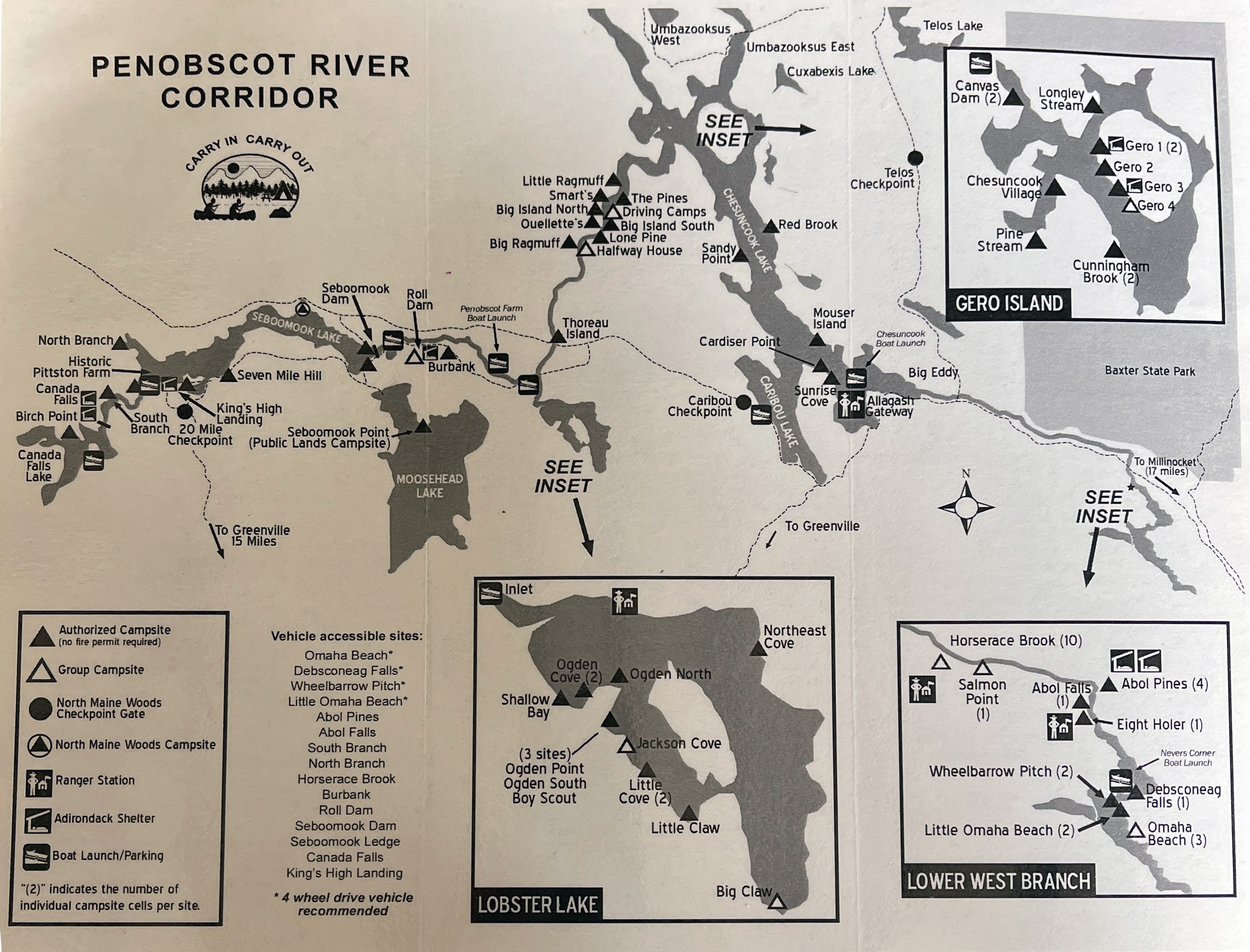
We didn't do anything that ambitious. We put in at Lobster Stream and took out at Umbazooksus West on the northeast corner of Chesuncook Lake - 5 days, 4 nights with a stop at Lobster Lake.

Sandy beach at Ogden Point Campsite
We met on Tuesday night at Matt’s house on Cousin’s Island in Yarmouth, ME. Matt treated us to a great chili dinner, and we enjoyed the great views of Casco Bay until it was time for bed.

We were up early on Wednesday for the drive to Northwoods Outfitters in Greenville for the shuttle. We had our boats and gear loaded by 9:00, and we were on our way. It was a 3-hour drive to Lobster Stream on dusty, dirt logging roads. After unloading our gear and a quick break for lunch we were on our way down Lobster Stream to our first campsite - Ogden Cove on Lobster Lake.

Paddling down the Penobscot River
As its name suggests, Lobster Lake is shaped like a giant lobster claw. It is known for its white sand beaches and great mountain views. The wind was out of the northwest as we began our crossing from Lobster Stream toward Ogden Point, giving us a tricky tail wind. Everyone arrived fine, and we begin setting up camp and gathering fire wood.

The winds continued to pick up over the afternoon, with significant gusts in the late afternoon and early evening. We found whatever shelter we could, and had to rebuild the firepit with a larger wind screen in the back before lighting a fire. We cooked dinner, enjoyed a beautiful sunset and sat around the fire until around 10:00 when we called it a night. Total paddling for day 1 – about 3-miles.

Pine Steam Campsite
The winds were still blowing when we got up on Thursday. The original plan was to take a lay-over day to explore Lobster Lake, and perhaps hike up Lobster Mountain, but we were concerned about winds forecasted for the next few days. Instead, we decided to head back to the river while the wind was still manageable. With the decision made, we packed up camp and were crossing back over Lobster Lake into a strong headwind by 9:00.

Once again, everyone crossed with no problem. We took a quick break at the Lobster Stream put-in before continuing down the Penobscot River. Our objective was to get to the campsite at Pine Stream, which is one of the most popular on the river. We passed numerous empty sites along the way, and we were surprised that there weren’t more people on the river on the lead-up to Memorial Day weekend.

Exploring Pine Stream
The river is mostly flatwater, with the exception of some easy rapids along Big Island. Unfortunately, Bill and I ran up on a rock and dumped into the river. I was able to grab the boat, get it turned over (good thing everything was strapped in), and wade it over to shore. Bill had a little rougher time on the slippery rocks, but he eventually got to shore and into some dry cloths.

We were back on our way, and made it to Pine Stream at around 3:00. We set up camp, gathered wood, prepared diner, and enjoyed another amazing sunset. After the long paddle, much of it against the wind, I was in bed early – around 9:00. Total paddling for day 2 – around 18-miles.

Gero Island 1 Campsite
Friday was a lay-over day so we slept late, enjoyed a nice breakfast and took it easy napping (Matt and Bill), reading (me) and painting (Aaron) until around 2:00 when we headed out to paddle Pine Stream, a slow moving tributary of the West Branch. It started off as woodlands, and eventually became a large marshland. After about 5-miles a blowdown blocked our way, so we decided to turn around and head back to the campsite.

Back in camp we cooked dinner and apple crisp for dessert in the reflector oven. We enjoyed another great sunset before heading off to bed. Total paddling for day 3 - around 10-miles.

View of Mount Katahdin
The wind was calm when we got up on Saturday. We prepared breakfast and headed off for the short trip to Chesuncook Lake. When we arrived at Chesuncook, the lake was calm and we crossed over to campsite 1 on Gero Island. We set up camp, had lunch and did a second afternoon paddle to a pretty cove on the northeast corner of Chesuncook with great views of Mount Katahdin. Back in camp we cooked dinner, and Matt baked orange-cranberry scones for dessert in the reflector oven. We enjoyed and other great sunset before heading off to bed. Total paddling for day 4 - around 10-miles.

We got up early on Sunday for the short trip to Umbazooksus West to meet the shuttle. We arrived around 10:00, and the shuttle arrived around 10:30. We were back in Greenville at around 2:00 and got on the road after a quick lunch. Total paddling for day 5 – about 5-miles. No rain on the trip, but it poured on the way home – that’s the way it should be.


Links:

Sunday, March 1, 2026

Planning for Spring Camping - West Branch of the Penobscot/Lobster Lake

Back in February I got an email from Jonathan looking to start planning a spring camping trip. We decided on a Maine classic - the West Branch of the Penobscot in May. Unfortunately Jonathan has now dropped out due to family obligations, but the trip is still on. 

The classic trip is to put in below Roll Dam and paddle about 7-miles to Lobster Lake. After a night or two on Lobster Lake, paddle 15-miles to Lake Chesuncook and then 19-miles down the lake enjoying the great views of Mount Katahdin. 

We are not planning anything that ambitious - 5 days, 4 nights with a leisurely pace. For the shuttle, we will use North Woods Outfitters (NWO) in Greenville. They will drop us at Lobster Stream, and pick us up at Umbazooksus West. Here is the plan:
  • Tuesday, May 19th - assemble somewhere close to Greenville.
  • Wednesday, May 20th - get to NWO early - 8:00 a.m. to 9:00 a.m. NWO drives us to Lobster Stream (45.89223,-69.56466), which will take 2 – 3 hours. Paddle to Lobster Lake - camp at Ogden Cove camp site (45.857293,-69.54895) – 3-miles.
  • Thursday, May 21st – explore Lobster Lake and hike up Lobster Mountain - trailhead is near Jackson Cove (45.851017,-69.542996).
  • Friday, May 22nd – paddle half way up the river to somewhere around Lone Pine (45.997846,-69.49727) – 12-miles.  There are lots of sites in that area to choose from.
  • Saturday, May 23rd - finish paddling the river and across the top of Chesuncook Lake to one of the sites on Gero Island like Gero 3 (46.063178,-69.386223) – 11-miles.
  • Sunday, May 24th – paddle to Umbazooksus West (46.1302,-69.3687) – 5-miles. NWO picks us up at approximately 11:00 a.m. and drives up back to Greenville to pick up our cars. Load vehicles and head home.
For food, everyone will bring their own. It will make the logistics and packing a lot easier. In terms of boats, I’ll paddle tandem with Bill and plan to bring my Spirit II. 

Sunday, January 5, 2020

Penobscot River Paddling Trail

The Penobscot River Paddling Trail was initiated to provide campsites for paddlers traveling on the river’s main stem from Medway to Bucksport. Over a distance of 100 miles, the Penobscot offers a combination of flatwater and whitewater, and plenty of access points for day use to long distance trips. When completed, the campsites will provide a link between the East Branch of the Penobscot and the Maine Island Trail, both of which have established paddling trails. 

Saturday, January 4, 2020

Ideas for Spring Camping Trips

I got an email from Jonathan with some suggestions for our spring camping trip. His thoughts were pretty ambitious.

Allagash
Indian Pond Stream or Churchill Dam to Allagash Village. Put in depends on wind forecast. Five or six nights. Lakes and moving water.  Class II at Chase Rapids. Shuttle to/from put in to Allagash Village. Again last week in May – 8-hour drive from Woonsocket.
The Allagash Wilderness Waterway is Maine’s best known canoe trip and has attracted paddler’s for more than a century. Henry David Thoreau ventured into this region more than 150 years ago by traveling into the Allagash via the Mud Pond Carry from the West Penobscot watershed. One of the great appeals of the Allagash River is its combination of large, glimmering lakes with a swift moving river. Sourced by some of the largest lakes in Maine, including Chamberlain Lake, Eagle Lake, and Churchill Lake, the Alligash allows many options of multi-day canoe tripping throughout the 102-mile waterway.
Baskahegan Stream
Undiscovered gem in Northern Washington County. Newly established camp sites on Baskaheagan Stream and Lake. Three or four night trip. Short portage at Danforth (with resupply possible at a general store). Slow water and lakes but very pretty and remote. Self shuttle possible.  Second or third week in May – 6-hour drive from Woonsocket.
Mostly a flat water trip, this remote soft adventure is available from May to mid-June and in the fall when the water level is sufficient. A great 1-4 day canoe trip with several put-in and takeout options. Beginning off route 6 near Topsfield, you’ll paddle 7.75 miles down a remote scenic stream and deadwater on your way to Baskahegan Lake.  After crossing the lake, continue down the stream with some moving water, some flatwater and great wildlife viewing. Popular take out is in Bancroft above the confluence with the Mattawamkeag River.
Debsconeag Loop Paddling Trail
From a post on CanoeTripping.net - 6-hour drive from Woonsocket.
The Debsconeag Loop Paddling Trail is meant to be traveled in a clockwise direction, west from Spencer Cove across Ambajejus and Pemadumcook Lakes and then north across the watershed divide to the Debsconeag Lakes to return southeast on the West Branch of the Penobscot River. From Third Debsconeag Lake there is an optional side-trip to Fourth Debsconeag. This route contains several portages and two major falls along the West Branch of the Penobscot. Videos from Maine Tripper - Part 1 and Part 2.
Machias River
Just below 5th Machias Lake or at exit of 4th Machias Lake to Machias Town. Four or five nights. Several (maybe) optional and one compulsory portages. Mostly moving water. Shuttle from Machias Town. Second week in May (Beware – may overlap with Mother’s Day!) – 6-hour drive from Woonsocket.
With the feel of a northern river, this scenic and wild waterway is downeast whitewater canoeing and camping at its finest. The Machias River is less traveled than the Allagash, Penobscot, and Saint John Rivers, and easier to access. The headwaters offer a series of scenic lakes and marshes, while the river offers numerous class I-II rapids and several technical class III rapids that can be lined or portage.
St. John River
Baker Lake to Dickie (no desire to start at 5th St John Pond!). Six nights. Moving water all the way with a Class III on days 4 and 6. Usually have one day for a layover. Shuttle to/from Baker Lake. Last week in May – 8-hour drive from Woonsocket.
One of Maine’s finest remote canoe trips, the St. John River flows 128 miles from its headwaters at the St. John Ponds to the Allagash River just below the town of Dickey. The trip from Baker Lake to the Town of Dickey is 105 miles and can be done in six or seven days. The river has an even gradient and no portages. Later in the trip is the mile-long Big Black Rapids, and downstream from the Big Black Rapids and near trip’s end, is the Big Rapids, which are 2 miles long. Most groups put in at the outlet of Baker Lake.  Best run mid-May to mid-June.
St. Croix River
Classic Down East trip - could be a three/four/five night trip depending on how much of the lakes are included. The core trip is 2 or 3 days from Vanceboro to Kellyland. Mostly moving water and class I with one class II+ (Little Falls). Plenty of campsites but in theory one is meant to stick to the US or Canadian side for camping. Bring your passport! C&C Canoe for the shuttle. Second or third week in May - 6-hour drive from Woonsocket.
The St. Croix River arises in the small town of Vanceboro from its sources in East Grand and Spednic Lakes, and continues to its outlet with the Atlantic Ocean in Calais. The river meanders through the beautiful forests of eastern Maine. Featuring over 25 distinct rapids, ranging from light rips to Class II+ such as Little Falls and Canoose Ledge and the aptly named Rocky Rips. Trips on the St. Croix River can rage from 2 to 8 days with the most popular being a 4 day trip from Vanceboro to Kellyland.  
West Branch of the Penobscot River
Roll Dam to Chesuncook Village - could work as a 3 or 4 day trip. We probably would not be able to self shuttle - 7-hour drive from Woonsocket.
Best time to go is June through early September. Headwaters begin above Saboomook Lake. Below Saboomook there are 2 miles of class II-III rapids, which makes for an optional full day of whitewater canoeing. Below Roll Dam, the river flattens and widens out. It is 6.75 miles to where Lobster Lake enters on the right. A trip to scenic Lobster Lake (3 miles) can provide for a relaxing trip with its sandy beaches and beautiful setting. From the confluence of Lobster Stream and the Penobscot, the river flows easily for 15 miles to Chesuncook Lake. Chesuncook is a 19 mile paddle offering views of Katahdin to the east and a stop at remote Chesuncook Village to check out the local history and visit ‘The Store’.
East Branch of the Penobscot River
Katahdin Woods and Waters - 7-hour drive from Woonsocket.
Below the Grand Lake Matagamon dam is the scenic and rugged East Branch of the Penobscot River with whitewater rapids and views of the Traveler Mountains to the west in Baxter State Park. It is a 27-mile trip from the Matagamon Wilderness Campground to Whetstone Falls with several mandatory portages around scenic waterfalls including Haskell Rock Pitch, Pond Pitch, Grand Pitch and Hauling Machine Pitch. 
Conrad suggested some trips that are closer and a little less ambitious:
I decided that I wanted to do all of them, but we seem to be leaning toward the Allagash in May.

Sunday, July 7, 2013

Seboomook – West Branch of the Penobscot – July 5, 2013

Running one of the ledges
It's remote - accessed by driving on 37-miles of dirt logging roads, but Seboomook on the West Branch of the Penobscot is worth the trip.

Seboomook lies in what is known as the North Maine Woods - a consortium of private landowners (mostly paper companies) encompassing 3.5 million acres of working forest. The scenery is beautiful, and on this day, the black flies and mosquitoes were vicious. Fortunately, the bugs are not problem on the river, and we did see a bald eagle swoop down and catch a fish. 

We ran the section from the Seboomook Dam to the Roll Dam Campsites. The river was at a great level – 800 cfs, which I am told is a medium level.  We had five boats – Rod, Deb, Harland, Tommy and me.  The run consists of 11 ledges that at this level were probably class III.  The drop and pool nature of this river is unlike most other New England rivers, which have long boulder strewn rapids.  The drops are intense but very short with a large slow recovery pool below. It’s a great place to practice running drops and punching holes.

I swam once, on the third drop trying to eddy out on river right behind a rock.  Otherwise I ran the drops clean. 


West Branch of the Penobscot from Erik Eckilson on Vimeo.

Links: