Monday, November 30, 2020

Nashua River – Ayer to Groton – November 29, 2020

On the Bike Shuttle
Last weekend we were hiking along the banks of the Nashua River in the Groton Town Forest. This weekend we decided to go back and paddle that section of the river.


We would be paddling on the South Branch of the Nashua River, which arises at the Wachusett Reservoir in Clinton, MA and flows generally north for 56 miles through north-central MA and southern NH before emptying into the Merrimack River in Nashua, NH. The North Branch of the Nashua River arises west of Fitchburg and flows generally south for 30 miles until it joins the South Branch near Lancaster.

Approaching Groton Town Forest
This would be the third trip on the Nashua River this year for me, Jonathan and Conrad.  Our first trip was at the
Oxbow Wildlife Refuge in Harvard, and the second was the confluence of the North Branch and the South Branch of the Nashua in Lancaster.  Today we would be paddling the section from Ayers to Groton.  I have also paddled the section of from Groton to Pepperell with RICKA, and the section of the North Branch from Leominster to Lancaster.

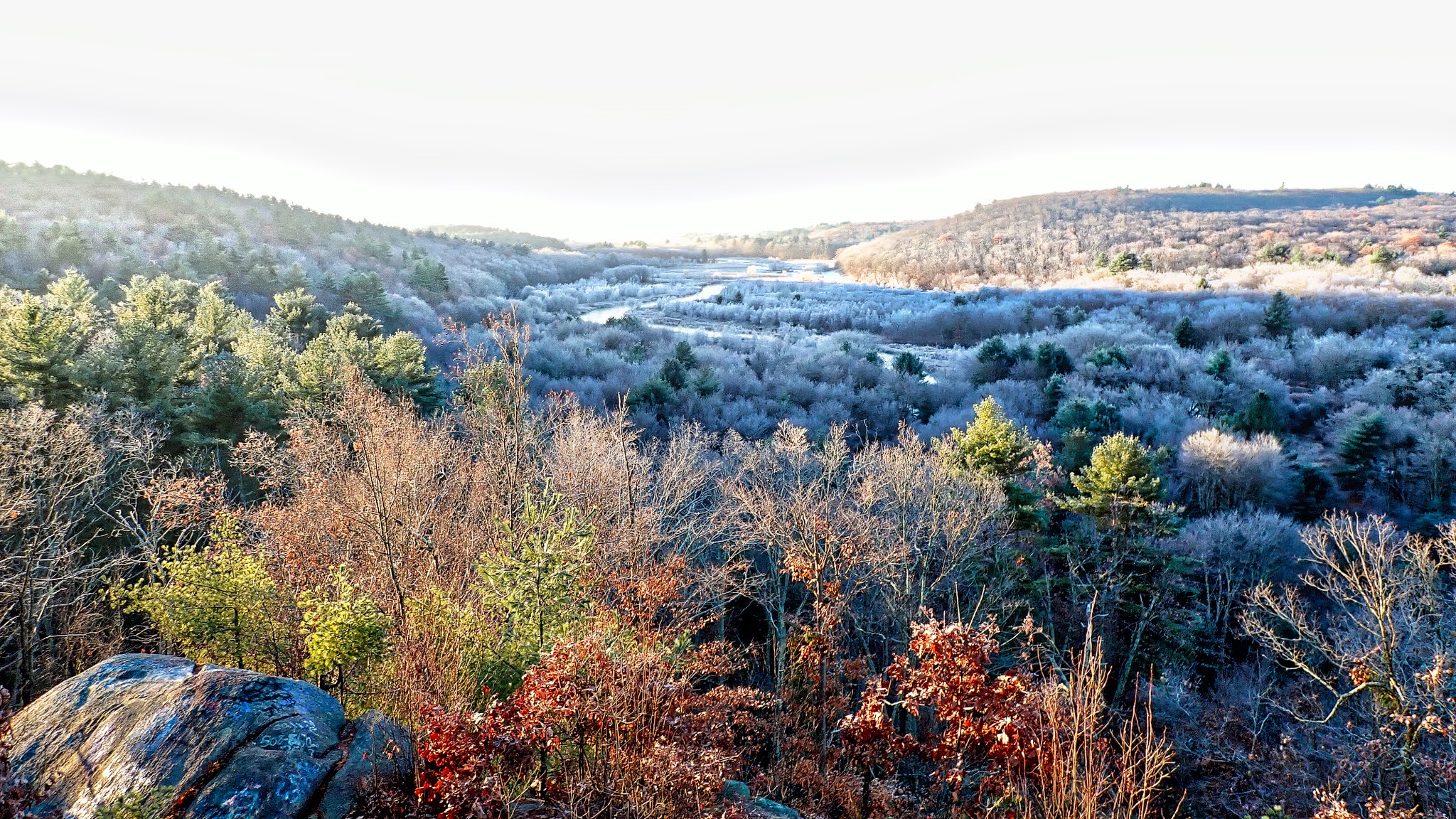
We put in at the northern end of the Oxbow Wildlife Refuge (Filter Bed Rd E, Ayer, MA 01432) and took out at the Petapawag Canoe Launch (Nod Rd, Groton, MA 01450) – about 6.5 miles. Jonathan and I did a 6-mile bike shuttle on the Nashua River Rail Trail. The river is pretty with huge pine trees lining the banks. It opens up significantly after the Squannacook River enters at the southern end of the Groton Town Forest.


And I earned another poem from Tom on p-net:

New England river badges,
begin to form its Morningstar.
Like diamond midst the granite rough,
she travels timeless far.

And in the flow path’s oft not seen,
so passage finds scar and scrape.
But pressing on comes wondrous light
through these facets in nature’s shape.
TW

Links.

Monday, November 23, 2020

Groton Town Forest – November 22, 2020

Plaque at the trailhead
Since I paddled on Friday, I decided to join Papa Joe and the crew for a hike at Groton Town Forest on Sunday.

The Groton (Memorial) Town Forest was established in 1922 to honor the veterans who gave their lives in World War I. Originally 180 acres, the forest has expanded to 513 acres over the years through purchases and donations of abutting properties. It is a nicely maintained property with 14 miles of marked trails (6.4 mile Town Forest Loop, and the 3.4 and 9.5 mile Town Forest Race Loops) and numerous unmarked trails.

Getting the group organized
We met at 9:00 at the trailhead at the end of Town Forest Road. It was a little cooler than I expected as we waited for the crew to gather, but nice once we started to hike. I’m not exactly sure the route that we took since Joe didn’t provide a map, but we went west to the railroad tracks, then south along the railroad tracks and Squannacook River to the Nashua River, and then back along the Nashua and Dead Rivers to the trailhead.

We decided that the Nashua River through Groton looked like a nice place to paddle. I’ve done the section north of here from Groton to Pepperell. We have also done the Oxbows south of here, and the section in Lancaster that includes the convergence of the North and South Branches. Another trip to add to the list.

Along the railroad tracks and Squannacook River
Links:

Saturday, November 21, 2020

Assebet - Acton to Concord - November 20, 2020

Bike shuttle from Lowell Road
I was checking my vacation time and realized that I still have three weeks of vacation, but only six weeks left in the year to take it. Nice problem to have. I sent an email to Jonathan to see if he could do some weekday paddling. The forecast for Friday was sunny and warm but maybe a little windy, so we decided to paddle the Assabet from Acton to Concord – 5-mile bike shuttle, 6-mile paddle.

The Assabet River arises in Westborough and flows approximately 34 miles west to meet with the Sudbury River at Egg Rock in Concord and form the Concord River. There’s lots of great flatwater paddling on the Assabet including the section from Gleasondale to the Ben Smith Dam. The section through Maynard is an easy class II with some nice surf waves by the Ben Smith Dam and along Walnut Street near the mills. 

No more rapids at the Damondale Dam
I was on my way up to Acton when I got a call from Jonathan to tell me that he had a family issue and wouldn’t be able to make the trip. Fortunately Conrad had signed on as well, so at least I wouldn’t have to do the trip alone. We dropped off out boats at the Acton Canoe Launch at around 10:00 and drove down to Lowell Road for the half-hour bike shuttle back.  

We got on the water a little before 11:00 and headed downstream. The river was low, but still fluid - 1.8 feet, 60 cfs on the Maynard gage.  This would be my fist trip since the removal of the Damondale Dam.  The easy rapids through the breach in the old broken dam were my favorite part of this trip. Oh well - still a great day.

Lowell Road Take-Out
Links

Sunday, November 15, 2020

King Philip Trail/Lookout Rock - November 15, 2020

King Philip Trail to River Bend Farm
My original plan was to paddle the canal and river loop at River Bend Farm, but on the way there I decided to check out Lookout Rock at sunrise. The view was beautiful so I decided to hike the King Philip Trail on its 2.5-mile loop from Lookout Rock to River Bend Farm instead.   
I started at the parking lot at Wolf Hill Road, and immediately took a wrong turn. I wasn't on the trail to Lookout Rock, but I did find a sign for the King Philip Trail back to the Hartford Avenue parking lot. I retraced my steps to find Lookout Rock, and snapped a few sunrise pictures. 

Through the pine grove
Then I decided to follow the King Phillip Trail back to Hartford Avenue. Several years I tried a sunrise hike from Hartford Avenue to Lookout Rock, but lost the trail as it when through a large pine grove. The trail is better marked now with blue trail markers, but it can still be tricky if you don't know where you are going.

From the Hartford Avenue parking lot the trail goes down through the picnic area, to the right through a grove of pine trees, across a small bridge and along the river.  The trail is well established, but there are lots of rocks and roots. It is relatively flat along the Blackstone River, but climbs about 150 feet to the top of Lookout Rock.  The round trip took me about 1.5 hours.

View from Lookout Rock at sunrise
Links:

Sunday, November 8, 2020

Turkey-less Turkey Paddle at Hopeville Pond State Park – November 7, 2020

Hopeville Pond
Traditionally, the end of the scheduled RICKA paddling season is the Turkey Paddle at Wallum Lake. This year the trip got moved to Hopeville Pond State Park in CT where the COVID restrictions are a little less onerous.

Hopeville Pond State Park is located on the Pachaug River – a 16-mile river arising in the Pachaug State Forest and emptying into the Quinebaug River. Pachaug State Forest is the largest state forest in the CT with over 27,000 acres on the CT/RI border.


Pachaug River
The forest was founded in 1928 and was originally managed by the Civilian Conservation Corps. Evidence of their work can still be seen in the pine groves, forest roads, and fire control ponds around the park. In 1938 the area around Hopeville Pond was designated as a state park.

We put in at the Hopeville Pond Boat Ramp and paddled up Hopeville Pond into the Pachaug River to the Pachaug Pond Dam before turning around.  Above the dam, Pachaug Pond is another nice place for a trip.


Pachaug Pond Dam

Links:

My Pictures

Hopeville Pond State Park

Pachaup Pond Boat Ramp