Showing posts with label Planning. Show all posts

Thursday, August 14, 2025

Planning another Allagash trip

I'm planning another Allagash trip with Jonathan in September - this time with Bill and Dan. As usual, we'll do five nights on the river with a spare/layover day to explore the lakes. Here’s the schedule:
  • Sunday, September 7th - assemble at Jonathan’s in Wiscasset in time for dinner.
  • Monday, September 8th – leave Wiscasset early for the 5-hour drive to Churchill Dam - camp at the Jaws.
  • Tuesday, September 9th - spare day to explore the lakes – another night at the Jaws. I would love to get down to Eagle Lake to see the locomotives if the putt-putt is working - 20-mile round trip.
  • Wednesday, September 10th – run Chase Rapids - camp at the Ledges on Umsaskis or Jalberts on Long Lake.
  • Thursday, September 11th - Long Lake Dam (portage) - camp at Inlet or Outlet on Round Pond.
  • Friday, September 12th - Round Pond to Five Finger Brook - camp at Five Finger Brook or Cunliffe Depot. I wouldn’t mind seeing the log haulers at Cunliffe Depot again.
  • Saturday, September 13th – early start down to Michaud Farm to meet Norm L’Italien (Pelletier’s Campground) for the ride back to Churchill Dam. Drive back to Wiscasset for dinner, or the long drive home.
We'll paddle tandem in Jonathan's Explorers. We’ll bring coolers with real food for as long as possible. Lunches and drinks are BYO. Jonathan will bring cooking gear and G&T for the 6:30 sundown meeting. Everyone will bring their own chair, camping gear, coffee mug, and other refreshments. We'll have to figure out who’s doing what for meals, and the remaining group gear.

The last time we were there the river was between 2,500 and 3,000 cfs. Today it is at 451 cfs - about what it was when we were there in 2022

Hopefully they will get some rain.

Thursday, March 27, 2025

Planning for Spring Camping - Baskaheagan Stream

There’s finally a camping trip in the works. I only did a couple of overnight trips last year, and work is making it tough again this year, but we now have a spring trip on the calendar - the Baskaheagan in Maine.

Jonathan described this trip as an undiscovered gem with numerous campsites that allow for an easy 3 or 4 night trip. It’s mostly flatwater and lakes, but very pretty and remote. The trip is dependent on water levels and can typically be paddled from early May to early June, and in the fall when the water level is sufficient.

Based on Jonathan’s experience last year we can expect a somewhat boney run to the first campsite on the river. Then river/lake to the first island campsite. Then lake and quickwater to the second campsite. After that there is a short carry around the dam in Danforth followed by some class I/quickwater to the takeout above a class III pitch.

Here is the plan:
  • May 16th – we all gather at Jonathan’s in Wiscasset.
  • May 17th – pack up for the drive up to the White Farm Road put-in in Topsfield. Run the shuttle, and then paddle down to the Upper Baskaheagan Campsite for the night - 1.5 miles.
  • May 18th – continue down Baskaheagan Stream to Baskaheagan Lake. Camp at either the Long Island or Round Island Campsites – 9-miles not including any exploration of the lake.
  • May 19th – continue across Baskaheagan Lake and renter Baskaheagan Stream. Camp at the Narrows Campsite near Crooked Brook Flowage – 12 miles.
  • May 20th – continue down Baskaheagan Stream to the take-out at 2000 Road in Bancroft with a portage of the dam in Danforth – 10 miles. Pack up and drive back to Wiscasset for the night.
  • May 21st – get up early and drive home.
So far the group is me, Jonathan, Conrad, Ellen, and Jules. Should be a lot of fun. Here's hoping for water, nice weather, and not too many bugs.


Tuesday, October 1, 2024

Planning a Sea Kayak Expedition

Imagine sitting on the beach as the sun sets in distance, or exploring islands that you can only reach in your sea kayak. Planning a multi-day sea kayak expedition can get you to these places, but is very different than planning a day-trip. Here are some things to think about as you plan your sea kayak expedition.

Know your group.

The trip that you do will be largely driven by the goals, skills and experience of the group. The group should be large enough to provide support and camaraderie, but small enough not to impact the environment. Four to six paddlers is usually the maximum group size.

Where will you go

Pick a location that is appropriate for the skills of the group and plan your route with options to avoid getting weather bound if conditions change. You may need to stay in protected areas when conditions are challenging, and move out into open water to cover distance when they improve.

Planning your trip

Planning can begin as soon as you choose your expedition location. Begin thinking about paddling distances, camping locations, tides and local conditions. You will need to build flexibility into your plan to account for changing weather conditions, and it might be a good idea to include a lay-over day just in case. For longer trips, you will also need to think about resupply locations for fresh food and water.

Navigation

Since you will be traveling along potentially unfamiliar shorelines, good navigation skills will be needed. You will need navigational charts and maps for the area. You will also need a deck mounted compass for following a heading, and a hand compass for taking bearings and working out your location. A GPS can help your navigation if you have already entered way points for lunch spots, campsites, etc.

Packing your sea kayak

When packing your kayak, you need to be careful to keep the boat trim by distributing the weight evenly from bow to stern. Try to pack heavy items like food and water toward the middle, and lighter items like sleeping bags and clothing in the ends. You will need a variety of drybags to protect gear that needs to stay dry but still needs to fit through those oddly shaped hatches.

Here is what I bring, and how I pack it in 
my P&H Capella 166 RM:

Paddling Gear

Kayak with bulkheads and hatch covers
Paddle
PFD
Hat
Sunglasses
Camera (PFD pocket)
Paddle Shoes
Spray Skirt
Bilge Pump (behind seat)
Paddle Float (behind seat)
Tow Belt

Deck

Spare Paddle
Charts/Maps (waterproof case)
Hand compass (waterproof case)
GPS
Deck mounted compass
Water Bottle

Front Hatch (tends to be the driest)


Sleeping Bag
Sleeping Pad/Pillow
Camp Clothes (appropriate for season and length of trip)
Camp Shoes
Personal Items (Poop Kit, Flashlight/Head Lamp, Toiletries)
Electronics (Phone/Satellite Communication Device)

Rear Hatch

Tent with Ground Cloth and Stakes
Tarp with Poles and Stakes
Camp Chair
Mess Kit
Stove with Extra Fuel
Fire Kit (Starter, Matches, Hatchet and Saw)
Clean-up Kit (Soap with Scrubby)
Hand Sanitizer

Day Hatch

Paddle Jacket
Snacks
Sunscreen
Bug Spray
Water (appropriate for length of trip)
Food (appropriate for length of trip)
First Aid Kit


When paddling with others, you might be able to consolidate gear and bring some other luxury items.

Choosing your campsite

In most cases, your campsite choices will be limited to established campsites. When choosing a campsite, you should look for a site that provides shelter from the prevailing winds, has enough flat ground above the high-tide mark for the group to set up tents, and minimizes the carry up and down the beach to the campsite if you are landing or launching at low tide. You also need to think about the site's orientation to morning winds and tides so you can launch in safe coonditions.

Setting up/taking down camp

On arriving you need to move your boat and gear above the high tide mark. If it is a short carry you might be able to carry boat with the gear loaded, but often it is easy to empty the boat first into a mesh sack or IKEA bag. Once the boat is safely stowed you can turn your attention to setting up your tent (and tarp if needed), gathering wood if you plan to have a fire, and cooking dinner.

The process of for taking down camp in the morning is pretty much the inverse – cooking breakfast, packing up your tent and gear, and loading the boat. To the extent possible, you should leave no trace – carry out everything that you carried in. 

Tents

Tents are available in many styles from tunnel to A-frame to geodesic dome. When choosing a tent think about the space that you need and the conditions you will be out in. Choose a tent with plenty of headroom, a full fly and good ventilation. When camping in exposed areas, your tent will need to withstand high winds and potentially heavy rain.

Sleeping Bags and Pads

The sleeping bag you use will depend on the season and the weather. To ensure comfort on cold nights, it’s a good idea to use a bag that's rated at least 10° colder than the temperature you will be out in. The sleeping bag's fill can be down or synthetic. Down bags pack small, but can be difficult to dry if they get wet. Synthetic bags are bulkier, but are easier to dry.

Sleeping pads have two functions - comfort and insulation. Inflatable sleeping pads are usually the best option due to their small sized when deflated. Inflatable pads have come a long way in terms of comfort and durability, but can be a little pricey - don’t skimp. Pads designed for colder weather usually have an R-rating of 4.0 or higher.

Camp cooking

The trip you do will definitely influence the food that you bring. In a sea kayak you have limited space, so a backpacking stove is the best option. The easiest meals are dehydrated or freeze dried since they are light, take up little space and are easy to prepare and pack out. If you have room you can cook fresh food on the stove or on the fire, but you will also need to bring pots, pans and utensils.

Should I bring or collect water?

Between drinking and cooking, most people will need around 2-liters of water a day. It is best to carry fresh water in water bag or plastic bottle (2-liter soda bottles work well). If you are going to be collecting water from natural sources you will need to boil, chemically treat (Aquatabs) or filter the water before using.

Campfire

If your campsite allows a campfire, be sure to use the established fire ring, or have your fire on the beach where it will have a minimal environmental impact. A fire pan is also a good option, and makes it easier to clean up the fire pit before you leave.

When collecting wood you will need a mixture of sizes from small to large - tinder to light the fire, kindling to establish the fire and fuel to feed the fire. Firewood should be collected selectively to leave the site and scenery as undisturbed as possible. A folding saw or small hatchet will make processing wood easier, and driftwood or standing/hanging deadwood are usually the driest.

Leave no trace

Aways leave the campsite better than you found it. You will need to pack out everything that you bring in, and that may include human waste if the campsite does not have a privy.

Links:

Monday, June 3, 2024

Planning for Spring Camping - Connecticut River - Bloomfield to Guildhall

I was getting worried that I wasn’t going to get out on a spring camping trip this year. so I sent an email to Bill to see if he would be interested in a short trip on the Connecticut River. We decided on a three-day, two-night trip the last week in June, which actually makes it a summer trip. Close enough - Luther’s Troopers will be out again!

Here is the plan:

June 27th - Leave early and put-in at Debanville Landing – mile 348. A unimproved path at the mouth of the Nulhegan River - park by the Northern Forest Canoe Trail kiosk on the other side of Rt. 102.  
44° 45' 5.2344" N71° 37' 58.6524" W

June 27th - First Night at Maine Central Railroad Trestle Campsite (VT) – mile 341. A beautiful campsite maintained by the Northern Forest Canoe Trail. The site is immediately downstream of granite railroad trestle, on the Vermont side.  
44°40'34.0"N 71°35'33.1"W

Intermediate Take-out - Maidstone Bridge – mile 336. Cartop access on New Hampshire side, down river of bridge.  44° 39' 6.354" N, 71° 33' 44.3232" W

June 28th - Second Night at Samuel Benton Campsite (VT) – mile 334. The campsite is situated in a grove of trees on a sandy bluff, at the edge of a field, on privately owned farmland - we stayed here in 2017.  44° 37' 46.362" N, 71° 32' 50.3196" W

June 29th – Take-out at Guildhall/Wyoming Dam – Mile 323. Take-out is located immediately upstream on the Vermont side. A portage trail takes paddlers up to Rt. 105.  44°33'50.8"N 71°33'33.1"W

This is part of the trip that I did with Bill, Tommy and Mena back in 2017. I have the two sites are booked in the Campsite Registry of the Connecticut River Paddlers Trail. 

Bill and I on the Connecticut River in 2017
Link:

Saturday, January 20, 2024

Camping at Gardner Hill Town Forest

Al reading the reg's
I did a hike with Papa Joe and the crew at the Gardner Hill Town Forest in Stow, and we hiked by a nice campsite along the Assabet River. It has a fire pit, benches, picnic table and nearby boat launch. It can be used for group camping with a permit from the Stow Conservation Commission. I don’t remember exactly where it is, but it is down near the Orange Trail across from the airport. Dan knows where it is and has already talked to the conservation commission about camping there in the spring. I'm in!

The campsite in winter

Monday, December 18, 2023

Winter Camping

We are planning to do an overnight camping trip on New Year’s weekend, so it’s time to think about cold weather camping. At this point, we are not expecting snow, possibly rain and relatively warm temperatures (days in the 40’s, and night in the 30’s), but there are still some things to consider when camping in cold weather.

Tent - a three-season tent will probably work fine for this trip, but a four-season tent is even better. A four-season tent is designed to withstand heavy snow and wind. The tent fabric is heavier, which allows it to retain heat better. I'll be using my father's Eureka! Expedition. You can't find this tent today, but it was originally designed as a mountaineering tent. Here are a couple of advertisements from the late 1980's. 


Sleeping Bag – to ensure comfort on cold nights, it’s a good idea to use a bag that's rated at least 10° colder than the temperature you will be out in. I have my father's Sumberjack Quallofil winter bag with draft tubes at the zippers, and drawstrings at the shoulders and on the hood to help keep the heat in the bag. I can't tell from the bag itself, but it looks like what they used to sell as the Boundry 0.

Sleeping Pads - in cold weather its best to use two sleeping pads to keep from losing heat to the cold ground - a closed-cell foam pad on the tent floor, and an inflatable pad on top of that. Pads designed for winter use usually have an R-value of about 4.0 or higher. I'll use my father's ¼” closed-cell foam pad and a Klymit Static V insulated pad with an R-value of 4.4. I also have my father's original Therm-a-Rest - they don't make them like that anymore.

Clothes – as always, dress in layers to match the conditions – a base layer next to the skin, then insulating layers to provide warmth, and finally outer layers to protect against rain and wind. Look for synthetic fabrics or wool that dry quickly and wick perspiration away from your body. Don’t forget a hat, gloves and appropriate footwear for the conditions. Be sure to adjust your layering before you over-heat or get cold, and bring warm, dry cloths to sleep in.

Stoves - liquid-fuel stoves like the Whisperlite work fine in below-freezing temperatures. Canister stoves like my Jetboil need to be kept above freezing to produce vapors and work properly. When in doubt, cook on the fire.

Food – your body generates heat as it digests food, so if you’re feeling cold try eating some food. (Moving around will also help.) Before you go to bed, have a snack to keep your metabolism going and keep a candy bar nearby if you get cold in the middle of the night. I don't think we will need to worry about having enough food with this group.

Water - don't forget to stay hydrated. I usually bring jugged water, but in the winter you may need to pump or melt water. 

I'm lucky that my father was a winter hiker, so I have a lot of his old gear. For real winter camping you need to get out in the snow, but we'll try that another time.

Wednesday, October 25, 2023

Planning a Canoe Camping Trip

What’s not to like about canoe camping. You spend the day paddling in nature’s beauty, and then spend the night relaxing around the campfire. I did my first canoe camping trip 2012, and I’ve been hooked ever since. I soon learned, though, that there is more to canoe camping than meets the eye. Planning is the key to a safe and fun trip.

Don't forget to plan for the shuttle
What trip will you do?


Canoe camping trips can run the gamut from easy overnights to month-long excursions, and anything in-between. Choose a trip that fits the group’s skills and schedule. Water levels and weather will determine the best time to run the trip, and the potential hazards you might face. 

For beginners it is a good idea to start off with shorter, easy trips before moving on to longer, more ambitious ones. You will also need to arrange the shuttle in and out, which can add a day or two to each end of the trip.

Crew of five at the end of a trip
Who will you go with?


Your friends of course! If they are not your friends at the start, they will be your friends when you finish. You can solo if you wish, but a group of four to six is my preference. More than that and it can get crowed in camp. Less than that and you may not have enough support if things go wrong. Choose a group with appropriate skills and a willingness to share camp chores.

When deciding on the group, you need to make sure that everyone agrees on the focus of the trip. Some people prefer an easy day of paddling with time in camp for nice meals and adult beverages. Others want to do 40-mile days and have oatmeal for breakfast and dinner (skipping lunch). Make sure the group agrees on where the trip falls in this range.

Chili for dinner
What food will you bring?


The trip you do will definitely influence the food that you bring. On trips where portages are few and weight is not an issue, you can bring coolers filled with fresh food. You will also need cooking gear, which takes up additional space. On trips with portages where every ounce counts, the food is more likely to be dehydrated or freeze dried and cooked on a backpacking stove.

Water jugs of different sizes
Should I bring or collect water?

You will also need a supply of fresh water. Between drinking and cooking, most people will need around 2 liters a day. It is always best to carry in fresh water. You can use a hard jug or water bag. During the trip, it is preferable to resupply from a tap if possible. If you are going to be collecting water from natural sources you will need to boil, chemically treat (Aquatabs) or filter the water before using.

Layering for the conditions
What about clothes?

Canoe camping is a water sport, so you should plan to get wet. Cotton cloths should be avoided. I tend to bring synthetic fabrics rather than more traditional wool. Wools socks are the exception – I never forget the wool socks. Layering allows you to be comfortable regardless of the conditions. Outer layers protect from wind and rain. Inner layers provide insulation. Don’t forget a hat and gloves if gets cold, shoes for camp, and your toiletries.

A roomy campsite
Campsites

Unless you are traveling in the remote wilderness, you will probably be camping in established campsites. The perfect campsite is elevated above the river on a flat section of land that has nice views of the surrounding landscape. If you are lucky, your campsite will have a picnic table with a ridgepole for your tarp, a fireplace, and maybe even an outhouse or thunderbox. Find a level spot for your tent that is away from dead trees and sparks from the fire.

Rain tarp is up - just in case
Tarps


If rain is in the forecast, the first thing that goes up is the tarp. Tarps are usually rigged for protection from rain, but can also be used to protect from sun or wind. A good tarp must be large enough to cover the group and have lots of attachment points. Poles are nice, but tall sticks and paddles work just as well. You’ll need a collection of stakes and guy lines to rig the fly in different configurations.

Home for the night
Tents


There is nothing like waking up in the morning to birds singing and the sun streaming into your tent. Tents have come a long way from the heavy canvas tents of old. The nice thing about canoe camping is that there is room for a bit of extravagance. You don’t need to jam yourself into a tiny one-person backpacking tent, unless you want to. Choose a tent with plenty of headroom, a full fly and good ventilation. 

A room with a view
Sleeping Bags and Pads


Waking up all snug and warm in your sleeping bag can make it tough to think about climbing out of the tent. The sleeping bag you use will depend on the season and the weather. To ensure comfort on cold nights, it’s a good idea to use a bag that's rated at least 10° colder than the temperature you will be out in. The sleeping bag's fill can be down or synthetic. Down bags pack small, but can be difficult to dry if they get wet. Synthetic bags are bulkier, but are easier to dry. 

A good sleeping pad can make sleeping on the ground not just bearable, but quite comfortable. Sleeping pads have two functions - comfort and insulation. The simplest is a thin closed cell foam pad. Inflatable hiking pads pack small and have come a long way in terms of comfort and durability. Combination pads that inflate but also contain foam like the original Therm-A-Rest are also available. Pads designed for colder weather usually have an R-value of 4.0 or higher. 

Camp kitchen for a large group
Camp Kitchen


Your kitchen kit should include pots, pans and utensils. A good frying pan and large pot are essential, and you will also need a knife, spatula, serving spoon and tongs. Long handles make it easy to work around the fire, and fireproof gloves are a nice addition. Don’t forget a scrubber and biodegradable soap for the dishes, trash bags to pack out garbage. 

You will also need to decide if you will cook on the fire or the stove, or both. If you cook on the fire you will need a grill or fire grate, and your pots and pans will get covered in black soot – a badge of honor for many camp cooks. A plastic bag will keep the grime from your pots and pans off your other gear.

Sitting around the evening fire
Campfire


When a campfire cook has passed through a campsite you can always tell by the fire pit. It will be clear of ash and debris allowing ample room for wood under the grill. If it is round, it will be large with multiple cooking spots depending on the type of cooking to be done and the heat needed. Or it will be “U” shaped and just wide enough to support the grill.

When collecting wood you will need a mixture of sizes from small to large - tinder to light the fire, kindling to establish the fire and fuel to feed the fire. Firewood should be collected selectively to leave the site and scenery as undisturbed as possible. Softwoods are usually easier to find and burn the fastest. Hardwoods produce a cleaner, longer lasting fire and better coals. Make sure your matches are stored in a waterproof container. 

The morning coffee
For cooking, keep the fire contained under the pots and pans. It is often easier to cook with small sticks rather than large logs. The most important part of the cooking fire is the height of the grill – too low and it will be tough to get wood underneath, too high and it will take a lot of wood. A grill grate at 8” to 10” seems to work best. Shift the pans around to get the heat that you need and prevent hot spots.

You should always leave the campsite better than you found it, and that is especially true of the fire pit. Make sure everything that you place in the fire gets burned completely. Never burn foil, plastic, styrofoam, bottles or cans. Don’t leave anything behind, except perhaps a pile of dry wood for the next campers.

Backpacking stove with a cozy
Stoves


When I started canoe camping everything was cooked on the stove. Over time I have gravitated more to cooking on the fire, but that doesn’t mean that you shouldn’t bring a stove along. When firewood is not available, in bad weather, or if you run out of daylight a stove may be needed. Stoves range from two-burner base camp models like the classic Coleman stove, to small backpacking stoves. Having a wind shield or cozy will significantly increase the stove's efficiency.

Splitting wood - be careful
Axe/Hatchet or Saw


An axe or hatchet is good to have along to split wood - especially when conditions are soggy. Remember though that splitting wood is one of the most dangerous things that you can do in camp. A saw is a must for gathering and cutting firewood. I usually bring two – a straight, folding saw for gathering wood, and a folding bow saw for cutting it into lengths.

Dinner by lantern light
Lanterns and Flashlights


One of my memories of camping as a kid was lighting my father’s white gas Coleman lantern with silk mantles. It was very bright and made a unique sound when lit. Today, there are lots of small battery powered lanterns that produce the same light and are easier to carry. A headlamp is essential for working in the dark, and a flashlight is good to bring along as a backup.

Drybags ready to be loaded
Dry Bags and Barrels


Comfortable camping is all about keeping your gear dry, and drybags and barrels allow you to do that. Vinyl drybags are the most durable, but nylon coated drybags are lighter and easier to compress to fit in small spaces. I use both. Drybags use a roll-down top and heavy clips to create a water tight seal. Some come with pack straps for easy portaging.

I double bag critical items that need to stay dry (sleeping bag, camp clothes) in smaller nylon drybags before packing in the larger vinyl drybag. I also use mesh bags to organize things that I tend to use together. For me, two large dry bags (one for my tent, clothes and sleeping gear, and one for everything else) and a small day bag seem to work right. I know – I don’t pack light. I need to work on that.

Barrels provide a waterproof and animal proof alternative to drybags. They are especially good for storing food, and have the added benefit of serving as chairs and tables in camp.

On the portage trail
Portages


If portaging is part of the trip you will definitely need to pack light. I usually pack for a two carries – the first with my boat and lighter dry pack, the second with my heavier dry back, day bag and anything else.
 In some areas, a portage cart can be used on rock and root-free trails. On rivers, wading or lining may be an alternative to portaging, and you might be able to run easier rapids empty. 

Enjoying a safe trip
Staying Safe


Safety on a canoe camping trip is just like safety for any other paddling trip - except that you are paddling a loaded tripping canoe and may be days away from potential help. You will need to know the conditions (recognizing that conditions can change quickly), know your group and its skills, and plan accordingly. 

The best way to stay safe is to anticipate what can go wrong, and avoid it. The two most common issues that you will face are whitewater and wind. Whitewater rapids that can easily be run in an empty boat might be significantly more difficult in a loaded tripping canoe. The same is true for long crossings across wind swept lakes. Portaging rapids and sitting out windy days are often the best strategy. 

You should dress for the conditions and always wear your PFD. You should bring appropriate safety gear including a first aid kit, throw bag/tow line and pin kit. You will also need to bring appropriate navigation and communication equipment. In remote areas, a satellite communication device will keep you in touch and allow you to send and receive messages in case of an emergency.

Saturday, August 26, 2023

Another Allagash Adventure

Last year’s trip was so good, that we are going back to do it again. This will be the 30th run for Jonathan. I’ll never hit that total. Key points for this trip are:
  • Five nights on the river with one spare/layover day to explore the lakes.
  • Dinner on Friday 22nd when everybody gets to Wiscasset.
  • Minimum amount of dirt road driving in our own vehicles - use Norm and his van to shuttle us from Michaud Farm to Churchill Dam.
  • Dinner on Friday the 29th in Fort Kent.
  • Drive back Saturday 30th - 8-hours from Fort Kent, ME to Woonsocket, RI. 
Here is the schedule
  • Friday, Sept. 22nd – assemble in Wiscasset for dinner.
  • Saturday, Sept 23rd - up early, drive to Fort Kent, stay at Northern Door, dinner at Swamp Buck.
  • Sunday, Sept. 24th - cars to Michaud Farm, shuttled in by Norm to Churchill, camp at The Jaws.
  • Monday, Sept. 25th - spare/layover day to explore the lakes (could be another day depending on weather).
  • Tuesday, Sept. 26th - camp at Jalberts on Long Lake.
  • Wednesday, Sept. 27th - camp at Inlet or Outlet on Round Pond.
  • Thursday, Sept. 28th - camp at Five Finger Brook or Cunliffe Depot.
  • Friday, Sept. 29th - paddle to cars at Michaud Farm, stay at Northern Door.
  • Saturday, Sept. 30th - drive home after breakfast.
I am paddling tandem with Jonathan in his MRE. Group meals for breakfast and dinner. On our own for lunch. Jonathan is bringing the G&T's for cocktail hour.  

The Allagash is cranking along at ~ 8,000 cfs. Apparently at at anything above 5,000 cfs the the rangers encourage everyone to take out at Michaud Farm above Allagash Falls, which we are doing anyway. They release around 500 cfs at the Chase Rapids during the day even if they let it rip at higher levels at night.  

Day time temps in the 60's and 70's. Night time temps in the 40's. Lots of clouds and maybe a couple days of rain early in the week.  

Sunday, July 9, 2023

Allagash for All - An Overview from Jonathan Ludlow

This overview was prepared by Jonathan for the Penobscot Paddle and Chowder Society. I hope to be there when Jonathan completes his 30th visit.

Last October I completed my 29th visit to the Allagash Wilderness Waterway. Yes, I like the place.

It occurs to me that while my fellow Chowderheads are probably aware of the Waterway they may not realize what a wonderful place it is.

My strong impression from advertised club trips and accounts in the truly estimable trip book is that club members focus is either on courageous white-water descents on Class 3+ Spring run offs or on heroic saltwater voyages of discovery.

While I know that the PPCS tribe indulges in other modes of messing about in boats, I want to use this opportunity to promote what I consider the third leg of canoe/kayak sport – down river tripping. I will do this by describing the wonders of the Allagash Waterway and offering some suggestions for key factors to be considered in planning and executing a trip.

First of All – What and Where

The Allagash is a 100-mile-long protected limited access wilderness waterway that includes headwater lakes and 98 miles of North flowing river. There are no public roads, permanent habitations, or retail stores. There is no cell service. The waterway is surrounded by North Maine Woods administered forests. Access is over logging roads. It is as close to a pure wilderness experience as you will get east of the Mississippi.

The longest potential trip of 100 miles from Allagash Lake to Allagash Village involves only one significant portage. The waterway is dressed with 81 rustic camp sites equipped with a fireplace, picnic table, tarp rail and a proper outhouse. Very few of the campsites are car accessible. What is not to love?

Where to Go

The “Classic” Allagash trip starts at either Chamberlain Bridge or (in the Spring) Allagash Lake and ends at Allagash Village. These trips are a long haul – probably 10+ days. My personal recommendation, especially for first timers with a week to spend, is have a little less ambition and put in at either Indian Pond Stream or Churchill Dam. You will get to see the major sites, experience quite enough lake paddling and not miss any of the white water.

To my mind the best starter trip is from Churchill Dam to Michaud Farm. You will paddle the core of the Allagash and will have a comfortable five- or six-night trip. You will bounce around on Chase Rapids, cruise down Long Lake, run down to Round Pond and get to choose between all the best camp sites. The following year you can come back and run all the way to Allagash Village via Allagash Falls (and its 1/3-mile portage).

When to Go

My trips have spanned the last week in May and the first week in October. At both extremes there have been crispy mornings that can be mitigated by having a copious supply of firewood. The last week in May usually beats the black fly hatch and provides great views through the leafless forest. June is probably to be avoided on account of the aforementioned Simulium trifasciatum. July is a little busy with camp groups. My choice in the summer is late August or any time in September.

Who Should Go with You

You can solo if you wish but my recommendation is a group of four or six in tandem canoes. The mix of skills is not important. The critical issue is that you should all be there for the same reason. There are those for whom the primary goal of camping is sitting in camp and relaxing all day with adult beverages. Others want to do 40-mile days and have oatmeal for breakfast and dinner (skipping lunch). Make sure your party agrees on where they fall in this range.

Also, you should make it clear from the outset that the Allagash is not a “long weekend” trip. Unless you are blessed with a residence in The County you will need a day at both ends for travel so a five-night trip means setting aside at least a week.

What to Bring

You all know how to camp. In my mind the Allagash essentials include an ax and a saw (for all that firewood), a nice big tarp – the campsites are set up for tarps and it has been known to rain, and gear for cooking over the wood fire. I bring a small stove but seldom use it.

Oh, and an ABS/Royalex canoe. There are plenty of rocks and maybe a bit of dragging on late summer trips.

What to See

A hundred years ago the Allagash was a busy industrial site. The industry in question was the felling and transport of first growth forest timber. Many of the facilities are still in place, rusting in the woods or tastefully preserved for your inspection. The Tramway, the abandoned steam engines on Eagle Lake, and the Lombard Log Haulers at Cunliffe Depot are well known. You should not miss the museum at Churchill Dam nor should you fail to look at the camp sites and imagine them in their former roles as Native American camps, abandoned farm sites, or locations where old time guides brought “sports” from the city to enjoy the wilds.

Where to Camp

There are 81 official camp sites on the Allagash. I have some favorites that I am willing to share.
  • The Jaws above Churchill Dam – the best sunsets on the river and a handy first night spot if you are starting from Churchill Dam
  • High Bank opposite The Jaws - a nice private spot with great views
  • Jalbert’s on Long Lake – again sunsets and a private beach
  • Outlet on Round Pond - nice set up and handy for the spring on Round Pond
  • Five Finger Brook West - two words – Brook Trout. Do not tell anybody about this site. Please!
  • Cunliffe Depot - any bits and pieces from logging days and the Lombards
How to Get There (and Back)

The big question for an Allagash trip is where to leave your vehicle and/or whether to get shuttled at the beginning or end of the trip. If you choose to leave your ride at the take-out, you will be driving up Route 11 (The Old Military Road) to Fort Kent and will leave your vehicle at or near Allagash Village.

If you drive to the put-in, you can either get shuttled back to your car or have it driven out to your take-out by an outfitter. The roads to the put-in are logging roads, and you will have to pay tribute to North Maine Woods at their gatehouse. High ground clearance vehicles are recommended. Do NOT trust your GPS or you will end up in Ontario.

In either case you can do no better than engage Norm L’Italien of Pelletier’s Campground in Saint Francis. Norm is the Gold Standard. Enough said!

What to Do Next

Well, now that you are convinced, the thing to do is download and study the excellent guide available at aww-guide.pdf (maine.gov). So, learn the history, study the map, recruit the rest of your team, and wait for ice-out.

It is a magical place

For extra credit and pleasure hunt down a copy of “The Allagash” by Lew Dietz (the author of A Seal Called Andre). It is the very best read on the history of the Allagash Country.

Team Ludlow-Wheeler pulling into Michaud Farm at the end of a very
successful five-night trip in 1998. Yes, the kids did grow up to be river rats.

Thursday, August 25, 2022

Planning for Fall Camping - Allagash River

In January of 2020 we were planning an Allagash camping trip for the spring. That is also when we started to hear about COVID-19, and little did we know what was coming. Obviously, that trip never happened. 

Two years later in the spring of 2022 we decided to give it another try. COVID was still with us and we were halfway through the Greek alphabet for variant designations, but we were all vaccinated and boosted. One week before the trip I tested positive for COVID and the trip got cancelled. I felt terrible, but a couple of days later Jonathan tested positive as well - misery loves company. 

Well, I still want to get up to Maine for my first Allagash trip and Jonathan needs to keep his annual string of trips going, so four intrepid campers (Jonathan, Conrad, Julie and me) are planning to do the long-delayed Allagash trip this fall. The plan is to spend a couple of days on the lakes, and then paddle the Allagash River. Here is what Jonathan came up with:
  • Thursday, Sept. 29th - assemble at Jonathan’s in Wiscasset in time for dinner.
  • Friday, Sept. 30th – leave Wiscasset early for the 5-hour drive to Churchill Dam. Camp at the Jaws between Heron Pond and Churchill Lake.
  • Saturday, Oct. 1st - spare day – another night at the Jaws - explore Eagle Lake and visit the locomotives.
  • Sunday, Oct. 2nd - Chase Rapids - camp on Unmasks or Long Lake
  • Monday, Oct. 3rd - Long Lake Dam (line this one) - camp on Round Pond
  • Tuesday, Oct. 4th - Round Pond to Five Finger Brook - camp at Five Finger Brook
  • Wednesday, Oct. 6th – early start down to Michaud Farm to meet Norm L’Italien (Pelletier’s Campground) for the ride back to Churchill Dam. Drive back to Wiscasset, or the long drive home. 
We’ll bring coolers with real food for the first few days, then switch to freeze-dried. Lunches are on BYO. Jonathan will bring cooking gear and G&T for the 6:30 sundown meeting. Everyone will bring their own chair, camping gear, coffee mug, and other refreshments.  We'll have to figure out the remaining group gear.

Sounds like a plan - SYOTR in 35 days!

Sunday, August 8, 2021

Camping at Rocky Narrows on the Charles River

Call for reservations
I ran a RICKA trip on the Charles and we stopped for lunch at the Rocky Narrows Picnic Site. I noticed from the sign that you can camp there. It would make a nice paddle-in site for an overnight trip - put in at Dover Road and take out at Bridge Street. You could hike over to the King Phillip Overlook. No porta-potty, but there is a lot of space, and a fire ring. It would probably accommodate 8 to 10 people. Need to contact the Trustees at 508-785-0339 or charlesrivervalley@thetrustees.org.

Group campsite at Rocky Narrows
Links

Friday, April 30, 2021

Planning for Spring Camping – Lake Umbagog - June 7 - 10 , 2021

I really want to get out to do some spring camping, but nothing was coming together, so I booked some sites on Lake Umbagog for June 7 - 10.  

Umbagog Lake is located along the border of NH and ME near Errol, NH. The lake runs almost 11 miles north to south and is fed by the Magalloway River, the Rapid River, and the Dead Cambridge River. It is the source of the Androscoggin River. The lake is part of the Umbagog National Wildlife Refuge and Umbagog Lake State Park.  

Umbagog Lake State Park includes a base camp with 27 sites at the southernmost end of the lake that can be accessed from NH Rt. 26. There are 33 wilderness campsites located around the lake that are accessible only by boat. I crossed the upper end of Lake Umbagog when we did the Magalloway, Rapid and Androscoggin Rivers last fall.  

Bill and Earl have signed on, and here is the trip we planned:

Day 1 – meet at Umbagog Lake State Park and shuttle a car to the Errol Dam. Put in at the base camp and explore the southern end of the lake including the Dead Cambridge River. Head north to Big Island. Camp at site R9 on Big Island - 6 miles.

Day 2 – paddle north past Pine Tree Point and east to the mouth of the Rapid River. Camp at site R15 – 10 miles.

Day 3 – paddle up the Rapid River to the whitewater section - hike up the trail if we want. Paddle back along the north shore to the mouth of the Androscoggin. Camp at site R28 - 7 miles. 

Day 4 – paddle back down the Androscoggin to the dam - 4 miles.

Bill and I will be paddling my Spirit II. Earl will be in his kayak.  Extended forecast looks good for now - partly clouding and in the 80's. We can get firewood at the base camp, but Earl says we shouldn't need it - there is plenty around.

Lake Umbagog from the Magalloway River
Links:

Friday, January 8, 2021

Planning for Spring Camping - Connecticut River – McIndoe Falls to Bedell Bridge State Park or Bugbee Landing

Its time to start thinking about our spring camping trip. If we continue down the Connecticut River, the next section is Wilder Dam to Bellows Falls  - looks like a 3-night trip with one portage. We talked about doing it last spring, and then COVID hit.
 
We could also go back and do the section that we missed from McIndoe Falls to the Woodville. We section paddled Gilman Dam to McIndoe Falls. Then we started up again at Woodsville paddling down to Orford, skipping the section from McIndoe Falls to Woodville. We could paddle the section from McIndoe Falls to the Woodville staying at Stephen's Island or Fiddlehead Island. After portaging the Ryegate Dam, we would paddle past Woodville and stay the second night at Howard Island or Horse Meadow. If we did two nights we could take out at Bedell Bridge State Park, or continue downstream staying a third night at Vaughan Meadow and taking out at Bugbee Landing

Put-in - McIndoe Falls Access – mile 276 - small park on river left doubles as a hand carry access point.

First Night - Stephan's Island – mile 273 - peaceful island with sandy beach, towering pines, and rocky knoll.

Optional First Night - Fiddlehead Island – mile 273 - a large but often overgrown campsite located on the third wooded island in reach between McIndoe Falls and Dodge Falls. Rope swing!

Portage - Ryegate Dam – mile 272 - take out river left after sharp bend. Follow trail pass campsite, along edge of field, down an access road, and along a rough path to the river. Warning - put-in is rocky with difficult footing. (Length 0.3. Percentage wheelable: 0 .8)

Second Night - Howard Island – mile 265 - about 2 miles below the Woodsville Bridge. The northern campsite is located at the northeast end of this island with access on a moderately-sloped cobblestone bank. The southern campsite is at the southwestern corner of the island.

Optional Second Night - Horse Meadow – mile 262 - one of the first campsites established on the Upper Connecticut River, and recently re-established with the help of the Thetford Academy. Access is via a set of removable stairs situated just past the southern tip of the adjacent island.

Optional Second Night - Harkdale Farm – mile 259 - access on Vermont side at second large oxbow downstream of Howard Island, across from high eroding sand bank that meets small brook with fallen trees. (We stayed here last time.)

2-day Take-out - Bedell Bridge State Park – mile 255 - Boat ramp and picnic area at premier birding site.

Third Night - Vaughan Meadow - mile 253 - located on the Vermont side one mile below the old Bedell Bridge abutment. Located on a wooded bank after the river turns from SE to S, a few hundred yards north of the Bradford line. (we paddled by and missed this site last time.)

3-day Take-out - Bugbee Landing – mile  249 - the school allows camping in a mowed area adjacent to the boat launch. Paddlers planning to use the site are encouraged to contact the Bradford Conservation Commission in advance. Contact info: parks-recreation@bradford-vt.us 802-222-4727 ext. 210.

Three night trip is 28-miles with one portage at the Rygate Dam. Even below Woodville we would be able to stay at campsites that we haven't used before.

Thursday, August 27, 2020

Planning for Fall Camping - Richardson Lake

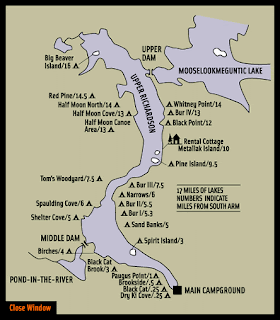
The alternative for our fall camping trip is Richardson Lake – a l6-mile long lake dotted with campsites maintained by Southerarm. Richardson Lake is divided at the Narrows into Upper Richardson Lake and Lower Richardson Lake. The lakes are impounded as a single reservoir by Middle Dam at the outlet to Rapid River on the western shore of the Lower Richardson Lake. The Rapid River flows 5 miles to Lake Umbagog. Primary inflow is Mooselookmeguntic Lake on the eastern shore of the Upper Richardson Lake. 

Links: 

Tuesday, August 25, 2020

Planning for Fall Camping - the Magalloway River

We missed this year's spring camping trip due to COVID-19, so I was really hoping to get out in the fall. I had mentioned it to Conrad, and was glad to get an email from him suggesting a 4-day camping trip on the Magalloway River.

The Magalloway River arises in Aziscohos Lake and flows generally south to Lake Umbagog. The upper two miles are popular class II/III (IV) rapids that run during scheduled releases (maybe I will try them someday). The remaining 15.6 miles is a mix of flatwater and quick water with beautiful views, lots of wildlife and several sites for overnight camping. Here is a description of the river:
  1. Azisochos Dam Access (mile 0.5) provide access to a section of Class II-III (IV) rapids, or is the take-out for the technical and hazard strewn class V rapids above. Dam releases are scheduled on summer weekends with dates posted on Boston AMC website.
  2. Wilson’s Mill (mile 2.25) is an informal access on private land that serves as the best put-in for a quiet water paddle. The next 6 miles are calm and picturesque, with meandering turns and mountain views.
  3. Pass under Littlehale Rd (mile 4.3) and enter a straight section adjacent to Route 16.
  4. Diamond Peaks (mile 9.0) is a set of basic campsites owned and operated by Northern Waters Outfitters. Advanced registration is required; call (603) 482-3817 to book.
  5. Wentworth Location (mile 10.7) is a formal hand carry access point. It includes a 10 car parking lot, a privy, and information on the Umbagog National Wildlife Refuge. It is in an abandoned oxbow on the right side of the river, so if you are taking out here you must turn off the river to paddle to the access. Across the street is Mt Dustan Country Store & Cabins (603) 482-3898) - a good spot to grab snacks or spend the night.
  6. Umbagog National Wildlife Refuge Headquarters (mile 13.8) offers a boat ramp and ample parking across the street. 
  7. Skirt the wetlands (mile 18) along the western edge of Umbagog Lake, home to osprey, bald eagles, and many water lilies.
  8. Steamer Diamond Boat Launch (mile 21.2) is an boat ramp on the Androscoggin that can extend a paddle on the Maggalloway.
Here is the trip as detailed on the trip map below:

Day 1 - put in at Wilsons Mills, ME with 10-mile vehicle/bike shuttle from the take out in Erroll, NH. Paddle 6-miles down to Diamond Peaks.

Day 2 - paddle 10-miles down the Magalloway and 4 miles across Umbagog for a total of 14 miles to the Cedar Stump Campsite at the mouth of the Rapid River on Lake Umbagog. We could also hire a Northern Waters pontoon boat to tow us the 4 miles across Umbagog and bring a big load of firewood (the deluxe version).

Day 3 – paddle 8 miles back across the lake and down the Androscoggin to the take out in Errol where we either camp out at the Northern Waters base camp or possibly the Clear Stream campground in Errol, or just drive home.

Day 4 - paddle the rapids on the Androscoggin in Errol and/or downstream and drive home.

Azizcohos Lake Dam has a FERC mandated minimum flow of 200 cfs after Sept. 16th. Sources, including the guide at Northern Waters, say that the river is navigable by canoe at this level. If it is too low, the default is Richardson Lake, which has lots of campsites through Southarm Campground.

Links: