Sunday, September 13, 2020

Wickford Harbor and Backwaters - September 12, 2020

Smith's Castle
I knew I wanted to run a RICKA Flatwater trip in September, but I couldn’t decide where. This trip was originally planned for the Concord River and then moved to the Sudbury River. As the trip approached and travel restrictions for RI residents going into MA continued, I decided to move it one more time to Wickford. We would be paddling in the protected waters around Wickford Harbor and its three small coves - Mill Cove, Fishing Cove and Wickford Cove.  

Wickford is located on the West Passage of Narragansett Bay and was established in the early 17th century when Roger William purchased land from the Narragansett Indians and established a trading post. In 1637, Williams sold the land to Richard Smith who constructed a large fortified house on the site, giving the house its nickname the “Castle”. That house was burned during King Philip's War, and the structure on the site today was built in 1678.

Paul at the mouth of Mill Creek
We put-in at low tide at Wilson Park and paddled out into Mill Cove near Rabbit Island. After passing Smith’s Castle we headed up the long narrow channel that leads to Mill Creek. There were egrets in the trees and sea gulls and cormorants diving into the water. We even saw an osprey fly overhead carrying a fish. At the mouth of Mill Creek a cormorant dove into the water and then came up in full flight right in the middle of our group – pretty cool.

I did some research and learned that Mill Cove is one of several tidal estuaries in Narragansett Bay that are home pogies or menhadens.These fish spend their juvenile years in the less saline waters where freshwater rivers and streams like Mill Creek enter the bay. The birds where probably taking advantage of low tide for a mid-morning brunch.

Taking a break at Sauga Point
We paddled back down the channel into Mill Cove toward Cornelius Island and into Fishing Cove. We took a break at Sauga Point at the northern end of the Wickford Harbor Breakwater.  

There are two stone breakwaters that form the entrance to Wickford Harbor from Narragansett Bay – the north breakwater from Sauga Point is about 1,130 feet, and the south breakwater from Poplar Point is about 825 feet. A mile long channel through the Outer Harbor and into Mill Cove and Wickford Cove allows recreational and small commercial boats to access Wickford's marinas and boatyards.

Boston Post Road Bridge
We headed out from Sauga Point and waited for the boats to pass before crossing the boating channel at the opening in the breakwater. From there, we paddled down the Outer Harbor and into Wickford Cove at the Wickford Shipyard.    

In the late 17th and early 18th centuries, Wickford grew to become a major port and shipbuilding center. Today, much of that historic village can be seen as you paddle into Wickford Cove along Washington Street. We continued down the cove toward the Boston Neck Road (Route 1A) Bridge and past the Kayak Centre boat ramp before heading back to Wilson Park. Another great day, but aren’t they all!  


Links:

Monday, September 7, 2020

Lincoln Woods - September 7, 2020

Third day of paddling in a row - a pleasant trip around Olney Pond at Lincoln Woods.


Link:
My Pictures

Sunday, September 6, 2020

Providence River – September 6, 2020

I got a text from Paul that he and Fran would be doing the Providence River trip, so I decided to join in. We put in at Bold Point in East Providence at around 11:00 and headed out across the harbor. After rounding Fox Point we paddled through the Fox Point Hurricane Barrier, under the I-way Bridge, and into downtown Providence. At the the confluence of the Woonasqatucket and Moshassuck Rivers we took a left and paddled up the Woonasqatucket River into the Basin at Waterplace Park. The tide was up, so we paddled under the Providence Place Mall and upstream as far as Olneyville. Fun trip, as always!


Links:

Saturday, September 5, 2020

Flatwater Quaboag – September 5, 2020

Early morning mist on the water
I wanted to do something different that didn’t involve an up-and-back, so I decided to paddle the flatwater section of the Quaboag from West Brookfield to Warren – a 9-mile paddle, and a 7-mile bike shuttle.

I was up before the sun to load my boat and get on my way. I dropped off my boat at the Fishdale Road Boat Ramp in Brookfield at around 7:30 and was at the take-out at Lucy Stone Park in Warren before 8:00. There was a trashcan that was the perfect height for a selfie, so I snapped a picture before I left.  

View from the Fishdale Road Bridge
I took the slightly longer but flatter bike route up Route 67 to West Brookfield and then down Route 9 to Brookfield. This also takes you past the two pretty town commons. I clocked 11-milles per hour on the radar as I passed through West Brookfield.  

At about 4-miles I stopped to take a picture at the West Brookfield Town Common, and realized that I had forgotten my camera back at the take-out. I turned around to go back for it, but figured it was unlikely that it would still be there. Fortunately for me it was.

Quaboag Pond
It was now close to 9:00, so it was too late for me to do the bike shuttle again and still get home at a reasonable hour. I loaded my bike and drove back to the put-in in Brookfield. I decided to paddle up into Quaboag Pond and back.

The Quaboag River arises fully formed from its headwaters at the southern end of Quaboag Pond. The river is big and wide as it flows west and meanders through a large flood plain down to West Brookfield. In West Brookfield the river turns south and flows through the woods down to Lucy Stone Park - the put-in for the whitewater run down to Palmer. Eventually, the Quaboag joins the Ware River in Three Rivers to form the Chicopee River. 

Quaboag River
I paddled upstream and into Quaboag Pond. The pond is known for motorboat activity, but this morning there were just a couple of fishermen.  I paddled about half way up the pond before turning back around.

The river is a little too wide and a little too flat for my liking, but it would be nice for a fall foliage trip.

Boat ramp at the Fishdale Road Bridge
Links:

Thursday, August 27, 2020

Planning for Fall Camping - Richardson Lake

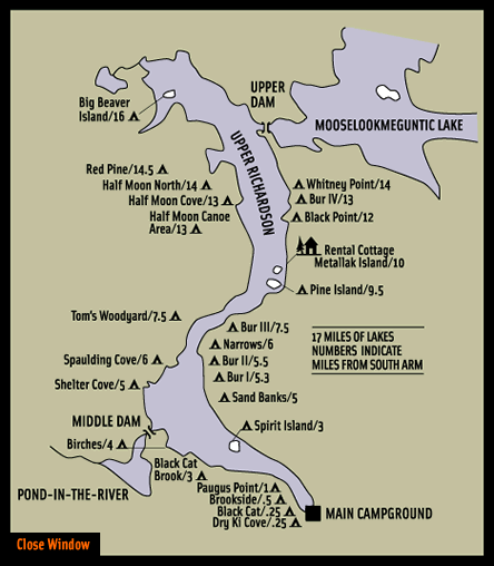
The alternative for our fall camping trip is Richardson Lake – a l6-mile long lake dotted with campsites maintained by Southerarm. Richardson Lake is divided at the Narrows into Upper Richardson Lake and Lower Richardson Lake. The lakes are impounded as a single reservoir by Middle Dam at the outlet to Rapid River on the western shore of the Lower Richardson Lake. The Rapid River flows 5 miles to Lake Umbagog. Primary inflow is Mooselookmeguntic Lake on the eastern shore of the Upper Richardson Lake. 

Links: 

Tuesday, August 25, 2020

Planning for Fall Camping - the Magalloway River

We missed this year's spring camping trip due to COVID-19, so I was really hoping to get out in the fall. I had mentioned it to Conrad, and was glad to get an email from him suggesting a 4-day camping trip on the Magalloway River.

The Magalloway River arises in Aziscohos Lake and flows generally south to Lake Umbagog. The upper two miles are popular class II/III (IV) rapids that run during scheduled releases (maybe I will try them someday). The remaining 15.6 miles is a mix of flatwater and quick water with beautiful views, lots of wildlife and several sites for overnight camping. Here is a description of the river:
  1. Azisochos Dam Access (mile 0.5) provide access to a section of Class II-III (IV) rapids, or is the take-out for the technical and hazard strewn class V rapids above. Dam releases are scheduled on summer weekends with dates posted on Boston AMC website.
  2. Wilson’s Mill (mile 2.25) is an informal access on private land that serves as the best put-in for a quiet water paddle. The next 6 miles are calm and picturesque, with meandering turns and mountain views.
  3. Pass under Littlehale Rd (mile 4.3) and enter a straight section adjacent to Route 16.
  4. Diamond Peaks (mile 9.0) is a set of basic campsites owned and operated by Northern Waters Outfitters. Advanced registration is required; call (603) 482-3817 to book.
  5. Wentworth Location (mile 10.7) is a formal hand carry access point. It includes a 10 car parking lot, a privy, and information on the Umbagog National Wildlife Refuge. It is in an abandoned oxbow on the right side of the river, so if you are taking out here you must turn off the river to paddle to the access. Across the street is Mt Dustan Country Store & Cabins (603) 482-3898) - a good spot to grab snacks or spend the night.
  6. Umbagog National Wildlife Refuge Headquarters (mile 13.8) offers a boat ramp and ample parking across the street. 
  7. Skirt the wetlands (mile 18) along the western edge of Umbagog Lake, home to osprey, bald eagles, and many water lilies.
  8. Steamer Diamond Boat Launch (mile 21.2) is an boat ramp on the Androscoggin that can extend a paddle on the Maggalloway.
Here is the trip as detailed on the trip map below:

Day 1 - put in at Wilsons Mills, ME with 10-mile vehicle/bike shuttle from the take out in Erroll, NH. Paddle 6-miles down to Diamond Peaks.

Day 2 - paddle 10-miles down the Magalloway and 4 miles across Umbagog for a total of 14 miles to the Cedar Stump Campsite at the mouth of the Rapid River on Lake Umbagog. We could also hire a Northern Waters pontoon boat to tow us the 4 miles across Umbagog and bring a big load of firewood (the deluxe version).

Day 3 – paddle 8 miles back across the lake and down the Androscoggin to the take out in Errol where we either camp out at the Northern Waters base camp or possibly the Clear Stream campground in Errol, or just drive home.

Day 4 - paddle the rapids on the Androscoggin in Errol and/or downstream and drive home.

Azizcohos Lake Dam has a FERC mandated minimum flow of 200 cfs after Sept. 16th. Sources, including the guide at Northern Waters, say that the river is navigable by canoe at this level. If it is too low, the default is Richardson Lake, which has lots of campsites through Southarm Campground.

Links:

Saturday, August 22, 2020

Tully Lake – August 22, 2020

Spirit Falls in November 2006
With medical issues and other obligations, my usual circle of paddling friends was not available this morning, but I still wanted to get out early. My first thought was a bike shuttle on the flatwater section of the Quabaug River above Lucy Stone Park, but I decided to save that for another day. Instead I decided to go the Tully Lake.  

I did my first trip at Tully Lake in October of 2006. My computer crashed around 2010 and I lost a lot of my early paddling pictures, but surprisingly I still have the pictures from that trip on Tully Lake. Wayne and I scouted during a torrential downpour, but we got some nice pictures at Spirit Falls. 

Early morning sun at the boat launch
The next weekend I ran a RICKA trip. We shuttled up to Route 68 and paddled down the Tully River through “beaver-dam-land”. The foliage was beautiful. I’ve thought about running that trip again many times over the years, but hadn’t been back until today.

Tully Lake is a 1,262-acre reservoir and flood control project constructed by the United States Army Corps of Engineers in 1949. The project prevents flooding of the greater Connecticut River and Millers River valleys and provides a variety of recreational opportunities, including a campground operated by The Trustees of Reservations. Tully Lake is an important link in the 22-mile Tully Trail, which I would like to try sometime.

Entering the Tully River
I was on my way early and arrived at the boat launch at the Tully Lake Dam around 7:00. The sun was still low and there was mist rising off the lake. As I launched my boat there was one lone fisherman - no one else in sight. 

I headed across the northern shore of Tully Lake past the campground and into the short section of the Tully River that links Tully Lake to Long Pond. There were a few cars in the parking lot at the Canoe Launch, but they must have been hikers since I didn’t see anyone else on the water. I continued to the top of Long Pond, but couldn’t find my way through the weeds to continue up the Tully River.

Lower drop at Doane's Falls
On the way back downstream I stopped at the take out for Spirit Falls. Spirit Falls is part of the Jacob’s Hill Reservation and is a multi-tiered waterfall that tumbles 150 feet down a rocky slope from Little Pond. Unfortunately, in our current drought the waterfall was bone dry.

I continued downstream and stopped at the Canoe Launch to walk over to Doane’s Falls. Unusually when I am in this area it is to paddle the Upper Millers, so the water levels are up. Today the water was low and I was able to walk up the rocks in the middle of Lawrence Brook to take some pictures.  

Back to the boat launch
Doane’s Falls is named for Amos Doane who built a large, 4-story mill above the falls in the early 19th century to manufacture doors, sashes, and blinds. Doane’s mill was the last of a series of sawmills, gristmills and fulling mills that stood on this site. Today, only the foundation of Doane’s mill remains.

By the time I got back to Tully Lake the place was mobbed – kayaks everywhere. Apparently there was a meet-up group having a picnic one of the Tully Lake islands – no thanks. I was on my way by 10:30, and home by noon.

Links: