Sunday, May 21, 2023

Housatonic - River Road to Housatonic Meadows - May 20, 2023

Jeff D. running the slalom course
It was slalom race weekend on the Housatonic, so I decided to join Paul D. for his trip on the Covered Bridge section so I could try my luck on the race course. It’s a 3-hour drive from my house, so I needed to get an early start.

The Housatonic originates in the Berkshire Hills of western MA and flows south for 150 miles along the western border of MA and CT before emptying into Long Island Sound. There’s a lot of great paddling on the Housatonic River. The best-known whitewater section is a class IV run known as Bulls Bridge - it's well above my skill level. There are also a couple of nice flatwater sections - one in MA - Sheffield to Ashley Falls, and one mostly in CT - Ashley Falls to Falls Village that we paddled as a fall foliage trip a few years ago.

Rescue practice
We would be running the quickwater section from River Road in Cornwall to the Picnic Area at Housatonic Meadows State Park in Sharon. We met at the picnic area and ran the shuttle up to River Road. This section is about 6-miles of quickwater with a couple of class II rapids – the Covered Bridge Rapid where the slalom course was set up, and the Ledges. The river was low and scratchy (2.5 feet, 500 cfs.) – I don’t think I’d make the trip again at that level. We put in on River Road, and paddled down to the Covered Bridge to run the slalom gates.

In whitewater slalom, racers compete to run a course of upstream and downstream gates set up in the rapids. Each gate consists of two poles hanging from a wire strung across the river. There are 18-25 numbered gates in a course that must be run in the proper order, with green gates being run downstream and red gates being run upstream. Upstream gates are typically placed in eddies. Downstream gates are often offset to require ferries or rapid turns. If a gate is hit a 2-second penalty is given. If a gate is missed a 50-second penalty is given. The paddler’s head and part of the boat must pass through the gate. In New England, slalom races are organized as part of the New England Slalom Series.
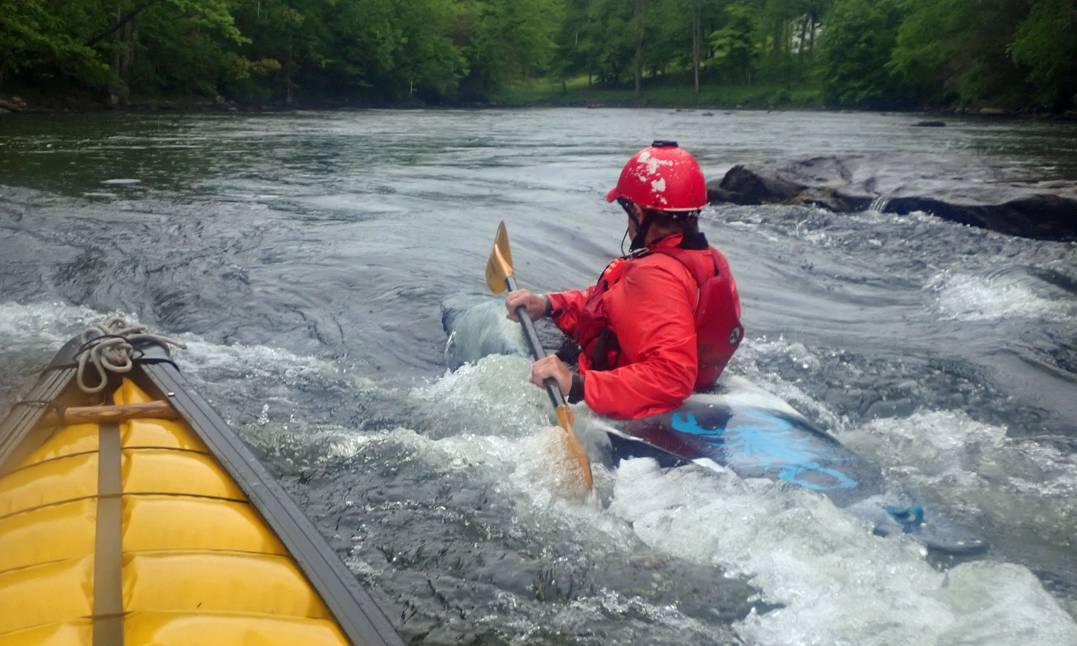
Surfing at the Ledges
I brought my Yellowstone Solo, so I knew running the gates would be a challenge – it was. I missed 6 of the 22 gates. The Yellowstone Solo doesn’t spin or side slip as fast a dedicated whitewater or slalom boat, but it was a lot more comfortable when I was running the quickwater sections downstream. Due to the low water, all of the gates were set up as downstream gates, which was unusual. Typically, there are 4 to 6 upstream gates included in the course.

After running the slalom course, we took some time practicing rescues and boat recoveries before heading downstream. We stopped for lunch at the Housatonic Meadows State Park Campground. It was pouring rain for the second half of our trip, the ride home, and most of the night. Over two-inches of rain fell, which gave the river a much needed boost for the slalom race today. Oh well, it was still a fun day.

The crew at the put-in above the Covered Bridge
Links:

Wednesday, May 17, 2023

Lackey Dam with the BVPC - May 16, 2023

Heading out on the pond
With Mother’s Day and our recent trip to Florida, it’s been a couple of weeks since I was out in my canoe. I decided to join the Tuesday night trip with the Blackstone Valley Paddle Club.

The Blackstone Valley Paddle Club was established in 2000 by the Blackstone River Valley National Heritage Corridor (now Park and Corridor) as a way to get folks out on waterways of the Blackstone River Valley. Over the years, the club has continued its Tuesday night summer trips getting thousands of people out on the water.

Up the Mumford River
This paddle would be on the Mumford River above the Lackey Dam. The Mumford River arises at Manchaug Pond in Sutton and Douglas, and flows 18-miles east until it joins the Blackstone River in Uxbridge. The many dams along the river provided power to 19th century textile mills. We had a good turn-out for this trip with 15 boats, including 2 canoes.

The crew was heading out when I arrived, so I paddled sweep with Cheryl and Tom. Early in the season the pond is clear, but later in the summer it will get choked-up with water chestnuts. We could see the young water chestnut plants growing up in the shallow water. We paddled up the pond into the Mumford River and up beyond Route 146. Fallen trees make this a little challenging once you get into the river, but you can actually make it quite a ways up.

Heading back down the pond to the put-in
Links
My Pictures

Sunday, April 30, 2023

River Rescue Clinic with Boston AMC – April 29, 2023

The crew get ready
I was looking through the AMC Activities, and saw that Conrad was coordinating a river rescue clinic for Boston AMC leaders at Zoar Outdoors. I signed up, but thought I would probably get bumped out by another leader. Fortunately, I didn’t.

I took my first swiftwater rescue class with the Blackstone Valley Paddled Club back around 2007. That class was also at Zoar Outdoor and focused on basic rescue skills such as safe and aggressive swimming, throw rope rescues and wading rescues. Shortly after that, I took a more advanced swiftwater course with the NHAMC that also covered strainers, rescue vests and rope-based rescues. Since it has been a while since I’ve had a refresher course, I was glad to get into this one.

Hand of God Rescue
This session focused on boat-based rescues with a minimum of equipment. With kayakers, this is the way most rescues happen these days. The session started with a discussion of trip safety, and what leaders should think about when planning and running a trip. 

After the classroom session we headed out to the river to review boat-based rescues including the “T” Rescue, Parallel/Side-by-Side Rescue, and the Hand of God Rescue. We also practiced emptying swamped boats and deep water recoveries. As a canoeist, its good to know that a Side-by-Side Rescue will work with a kayaker expecting a "T" Rescue.  Also good to know the best way to empty a swamped kayak. Those are skills I can use on the river.

Waiting for the next swim on Turtle Rock
After lunch we headed over to the Baby Gap (below Zoar Gap) to practice swimming and rescuing swimmers. We practiced swiftwater entries, safe/passive swimming, and aggressive swimming. 
We also practiced throw rope rescues, towing swimmers and a vectored Live Bait rescue.

Before packing up, we took a moment to remember Jocelyn Barrett, a frequent Deerfield paddler and active member of the community who passed away last week. It was a long, cold day, but definitely worth the time.  Glad I was able to participate.


Swimming below Zoar Gap from Erik Eckilson on Vimeo.

Links:

Sunday, April 23, 2023

Jim O’Brien Memorial Paddle - April 23, 2023

Paul running the Gorge Drop
In 2010, well-known local paddler Jim O'Brien died in a tragic boating accident on Hubbard Brook. Other than Gordon McKinney, the RICKA paddler who died on Esopus Creek in 1992, this is the only death of a local whitewater paddler that I am aware of in my time paddling. Each year, Jim's friends organize a memorial paddle for him on his home river – the Westfield in western MA. It’s a nice section of the river – Knightville Dam to Huntington, its dam-controlled so there is always water, and there is always a HUGE crowd. It is the bumper-boats of whitewater paddling, and I always make it if I can.

The Westfield River arises in the Berkshires and flows generally southeast for 78 miles to its confluence with the Connecticut River in Agawam. The river has lots of great whitewater paddling on three branches that join in Huntington to form the main stem - the North Branch (sometimes called the East Branch) that includes Pork Barrel, the Middle Branch, and the West Branch that includes Knightville. Several sections of the river have received national Wild & Scenic River designation.

Running the Gorge Drop
This was also the weekend of the Westfield River Wildwater Race, so we knew there would be a big crowd on the river. 
The race started in the morning, so I dropped off Paul and the boats at the dam at around 10:00 and headed back to the gazebo to meet the rest of the group for the shuttle. I was back at the dam at 12:00 for the group picture. The river was at 4.75 feet, 1,000 cfs – a typical dam release level. The run is mostly class II rock dodging until you get to the Gorge in the Gardner State Park.

The Gorge Drop is the main feature on this section of the river. It is a 3-foot ledge to the right of a large jumble of rocks. The easiest line is just to the right of the rocks. From there you can either catch the eddy behind the rocks, or ride the haystack waves downstream. I usually try to catch the eddy so I can climb up on the rocks and get some pictures of other folks coming through.  

In the eddy below the rocks
As I came over the crest this time I noticed three kayakers sitting in the eddy below waiting to surf the wave at the bottom of the shoot. My line was set, so in I went. I bumped into two of them and pushed one out the other side. Open boaters call that eddy clearing, and I did a pretty good job. They were OK with it, and I quickly got out of their way to take some pictures. 

From the Gorge Drop down to the take-out is quickwater and more class II rock-dodging. We usually stop at the Hill and Dale rapid on the way home to catch the carnage from the downriver race, but with the earlier start time, we missed it this year. Fun day, great community - just wish the get together was for a different reason.

Group picture at the put-in

Sunday, April 16, 2023

Otter Brook - April 15, 2023

Heading out
I was planning to do the NHAMC Class III step-up trip on the Ammonoosuc River, but it was running high, I wasn’t comfortable with the class IV section below Pierce Bridge, and I needed to be in Topsfield in the early afternoon so the timing wasn't good. Instead, I decided run Lower Otter Brook with Paul and Pat.

This would be a repeat of the old RICKA Whitewater days. I was looking back and found a trip report from March 2012 RICKA trip with Paul, Andy and Jeff that described Pat as the “new guy". It has been a while since I’ve done this run with them.

Party wave
Otter Brook is a tributary of the Branch River (not our Branch River), which is a tributary of the Ashuelot River, which is a tributary of the Connecticut River. Otter Brook arises in the town of Stoddard and flows generally south for 13-miles to join Miniwawa Brook at Route 101 to form the Branch River.

In 1958, the huge Otter Brook Flood Control Dam was completed to protect Keene and the other communities along the Ashuelot River. The flow on Otter Brook is controlled by releases from the dam. The gage on Otter Brook is no longer active, but the historical releases were around 300 cfs.

Paul running Otter Ledge
I headed up to drop of my boat at the put-in before meeting Paul and Pat at the take out for the shuttle. There was a good crew gathering at the put-in with groups from the NHAMC, MVP and WTWA. We were the first to launch and head downstream.

The top of Otter Brook is narrow and rocky as it twists and turns through the woods down to Route 101. We headed down slowly being careful for strainers that couldn’t be seen from the street. As it turned out, the only strainers were the two that you could see from the street – the first in the shoot on the right side of Otter Ledge, and the second about half way down Route 101 with a small opening on the left.

Pat running Otter Ledge
We worked our way downstream catching eddies, dodging rocks and surfing waves. With the strainer blocking my usual route at the ledge my options were limited – portage or run the ledge to the left. I decided to run the ledge to the left, and made it through fine except for a loud cracking sound as I boofed the drop. Not a drop of water in the boat. We bounced along the final section along Route 101 before pulling out at the take-out below the bridge.

We had two cars at the take out to run the shuttle for our second run. It would have been easy to shuttle boats up and back, but I insisted on putting all the boats on my car to head up in one trip. Unfortunately, both kayaks came off the rack as we were strapping them on, and I now have nice scratches on both sides of my car.

Erik running Otter Ledge
The second run was a bomber run since we knew where the strainers were. Pat and Paul snuck through the strainer to run the shoot at the ledge. I boofed the left side of the ledge again, this time hearing an even louder crack as I went over.

We pulled over at the take-out and ran one last shuttle back to pick up the cars. I flipped my boat over to empty out the water before loading it on my car and noticed a 3 inch crack in the bottom just under the pedestal, and a matching crack on the inside. Now I know what the loud cracks were. Except for the cracks in my boat and the scratches on my car, it was another great day.

Back to the take-out
Links:

Sunday, April 9, 2023

It's Miller Time - April 8, 2023

Paul in the waves below the lunch spot
I joined Paul and Pat for a joint RICKA/Penobscot Paddle and Chowder Society (PPCS) trip on the Upper Millers. I have paddled the Upper Millers many times since my fist trip in 2007 and never had a swim, until today – third swim in the last three trips.

I got an early start so I could drop my boat off at the put-in on Blossom Street in Royalston before heading down to meet up with Conrad at the take-out on Crescent Street in Athol. I needed to get home early to light the fire for the Easter Vigil Mass, so I wanted to make sure that my car was at the take-out. Conrad had an extra seat in his van, so I caught the shuttle with him. We had four from RICKA (Paul, Pat, the new guy Ben and me) and three from PPCS (Kenny, Ryan and Brendan). All three of the “chowderheads” were paddling open boats, so the open boats outnumbered the kayaks on this trip 4 to 3.

Pat in the waves below the lunch spot
The water on Upper Millers is controlled by releases from the Birch Hill Dam. The river was cranking along at 1,650 cfs, just under 7 feet on the South Royalston gage – the highest I have run it. There are three class III rapids. The first starts just below the put-in and continues down to the first railroad bridge – lots of big waves, just the way Paul likes it. The second is a little further downstream at Mile Long Rapid – a long class III rock garden that ends at the shelter at the Bearsden Conservation Area. I don’t remember Mile Long being that difficult, so maybe it was washed out. 

The last class III rapid is the Gorge that begins below an island after you pass the wave train at the lunch spot and the railroad tracks. I took a dump going over a pour-over at the top. I grabbed my boat, but after seeing what was downstream I decided to let it go and concentrate on getting myself to shore. It took some barrel roll swimming, but I got into a nearby eddy. From there, it was a long walk down a well-worn trail to the bottom of the rapid where Pat had corralled my boat. Three swims in the last three trips – maybe my new drysuit is jinxed. Not many pictures this time - bad setting on the camera.

Ryan from PPCS in the waves below the lunch spot
Links:

Sunday, March 26, 2023

Branch River - March 26, 2023

Jeff running Whipple Drop
Yesterday I was on the Scantic River to paddle the Scantic Spring Splash. Today I was on the Branch River to paddle the race course for the old Rhode Island Whitewater Championship.

The Branch River Race, later the Rhode Island Whitewater Championship, was established by RICKA in 1980 and was always run on the third weekend in March. It was the first race of the year on calendar of the NECKRA Downriver Series. The race continued for 25 years, but was eventually discontinued due to the high cost of insurance and problems with river access.

Mike running Glendale
RICKA has continued the tradition of running a spring trip on the Branch River. This year we were a week late and the group was small - me, Mike and Jeff. We met at the put-in below the Stillwater Mill at 10:00 to run the shuttle. Since the usual take out is now posted “No Trespassing”, we decided to take out a Mike’s house. The river was at 3-feet, 175 cfs. – low but runnable. The day was sunny and in the high 50’s/low 60's - it felt like spring.

The first half of this trip is actually on the Clear River. There were lots of blowdowns in this upper section. I got spun sideways on one strainer and dumped when the boat moved and I didn’t – second swim of the weekend, and the year. We ran Whipple Drop down the center and continued to Oakland, where the Branch is formed at the confluence of the Clear and Chepachet Rivers.

Jeff running Atlas Pallet
After portaging the Oakland Dam we headed down to Glendale. The Glendale Rapid was shallow and boney, but we bounced down using the left of center line. From there it is a nice quickwater run down to the Atlas Pallet rapid. We ran Atlas Pallet left of center and made it through fine.

The remainder of the trip is quickwater with one portage at the Nasonville Dam. The take-out at Mike's house worked out fine – “head straight for the fire station”. We often call this trip the Branch River "Icebreaker", but there was no ice to break this year!

The crew - Mike, Jeff and Erik - at the Oakland Portage
This picture earned us another poem from Tom on P-net.

!!!
From Idaho,
there’s a ghostly rustle.
Spiratoose Papa,
has grab ahold Mike Bussell!

To Have and Have Not?
I’d say what’s had here’s wicked style,
with The Old Man and I see,
melted Snows of to kill a man Rhode Isle. 
TW

Links: