Showing posts sorted by date for query whitewater 16. Sort by relevance Show all posts

Monday, June 15, 2026

Fife Brook in River Trippers - June 14, 2026

Bob has a group doing a wilderness trip on a remote Canadian river next month and wanted to practice whitewater in river trippers, so he organized a trip on the Fife Brook section of the Deerfield. With my sore knee, tandem paddling sounded great, so Aaron and I headed up with my Mohawk Whitewater 16.

There are two sections of the Deerfield with summer releases that are popular for whitewater paddling. Advanced paddlers often head to the Dryway in Monroe Bridge. This is a class III-IV section of river for experienced whitewater paddlers. We would be paddling the Fife Brook section, which is mostly class II, with the exception of Zoar Gap in the middle which is class III. This would be my 23rd run on Fife Brook, but the first in a tandem.

Aaron was at my house at 7:30 to drop off a new-to-me Mad River Explorer 17 and head off to the Deerfield. We met the crew at 10:30 at the Fife Brook put-in to run the shuttle down to Shunpike. The release was 800 cfs. from 11:30 to 2:30, so we practiced ferries and eddy turns/peal outs at the put-in before heading downstream.

Just downstream from the put-in is the first rapid known as Hangover Helper - a ledge extends across most of the river resulting in a 2-foot drop followed by a long wave train. We ran the drop and played in the waves before moving downstream.

The next rapid - Carbis Bend - is similar but smaller. A ledge extends out from the left side of the river producing a couple of easy surf waves. Aaron and I did a couple of surfs, but there were too many kayakers cutting our place in line, so we moved on.

Just downstream from Carbis Bend is Freight Train, which is a long wave train that ends with a large surf wave. The rapid takes its name from the speed that many people build up running through the waves, and the railroad bridge just downstream that carries freight trains across the river. We missed the tight eddy on the right, but were still able to get on the big surf wave.

After Freight Train we took a break for lunch at the Bridge to Nowhere before running Pinball. Pinball is a rock garden that’s a great place to practice eddy turns, peel outs and ferries. Aaron and I ran the entire rapid backwards ferrying from rock to rock

After Pinball is the Island Rapid. As the name describes, the river is split by an island. The usual route is to the left with large waves and fast moving water where the river reconnects at the end. Aaron and I were able to catch the eddy on the left and get some pictures of others coming through.

After the Island Rapid comes Zoar Gap – the largest rapid on this section of the river. We scouted it from the road and confirmed the usual line - just right of center down the shoot at the top, then left down the shoot at the large boulder.

Aaron and I went down last. We caught an eddy on the left on the way down, and then headed over to catch one of the of the rocks on the right. We ended up further downstream than I expected, and before I knew it we were in the Zoar Gap rapid.

Fortunately, Aaron had a better sense of where we were than I did. He guided us down the first shoot and lined us up perfectly for the second drop. Always trust your bowman. My record at Zoar Gap is now 23 attempts with 13 successful, 6 swims and 2 walks. I have been successful on my last 6 attempts

After the gap, we continued downstream to the Shunpike Rest Area. On the way home, we stopped at the Picnic Area in Shelburne Falls for Ozzy’s hot dogs and potatoes. Here is Aaron's video of the run.


There are a lot of unnamed rapids, but here are the named ones as best I could identify them:

Hangover helper 0:37
Carbis Bend 1:08
Freight Train 2:07
Surf wave below the RXR bridge 3:51
Minefield (ferry practice) 7:05
Mimi Beach 9:38
Island Rapid 10:02
Above Zoar Gap 10:54
Scouting Zoar Gap 11:33
Running Zoar Gap 12:17
Running Zoar Gap - Slo-Mo 12:54
Mini Gap 13:55
Bam Dance 14:30
Spin Out 15:04
Conjunction Junction 16:05
RXR Bridge on Lower 17:04
Waves on left before take-out 18:10


Links:

Wednesday, December 31, 2025

2025 Year End Review

Wood/Pawcatuck
Family obligations resulted in my paddling year getting off to a slow start in 2025. I did a solo trip in January on the Blackstone - Manville to Albion, and a group trip with Bill, Chuck and Jeff in February on the Wood/Pawcatuck - Alton to Bradford.  

Things started picking up again in March - especially for whitewater. Over the year, I got out on a lot of whitewater favorites including the Branch, Upper Millers, Scantic, Sugar, Knightville, Otter Brook, Crystal, Tville (1, 2), Fife Brook (1, 2, 3), the Dead and the Piscat. I also joined the Millbrook club with the purchase of a new (to me) Milbrook Outrage

Scantic Spring Splash
While it was great to spend so much time in my whitewater boats, it didn’t leave a lot of time for flatwater or sea kayak trips. I did lead joint flatwater/sea kayak trips on Point Judith Pond and the Narrow River. I also led a Blackstone Valley Paddle Club trip in Providence, a flatwater trip on the Charles, and helped with the RICKA Flatwater Training.

I did 45 trips including 16 flatwater, 14 whitewater, 12 sea kayak and 3 camping. My 11-year average is 53 trips/year, but with the slow start in January and February and a slow finish in December due to bursitis in my knee, I was well below that average this year. I was out 10 nights camping compared to 2 last year. I had one swim in Lower Poplar on the Dead compared to 4 swims last year. 

Narrow River
Here are some of my more significant trips:
Here is the video of some of my favorite trips of 2025.


I did get my sea kayak out almost every day of my summer vacation on Great Island including the RICKA trip on Point Judith Pond.


I didn’t do much hiking – just Noon Hill and Borderland State Park with Papa Joe. 

I did get out on three camping trips – the Baskehegan, Bastille Day on the Pawcatuck, and the Allagash.

I was also a presenter at the Introduction to Canoe Camping training held by the NHAMC, and the Introduction to Canoe/Kayak Camping training held by RICKA.

Allagash Wilderness Waterway
In terms of resolutions for 2025, I did OK. I did get out in my sea kayak, but always in protected waters. I didn’t get out into any open-water or exposed conditions. I did do more camping including the spring trip on the on the Baskahegan and the fall trip on the Allagash. I also did a lot of whitewater paddling, purchased my new Millbrook, and got back to the Dead for the first time since COVID. It was a blast.

In terms of resolutions for 2026, they are just like 2025.

  • Keep practicing with my sea kayak – I need to get out on more level 3 trips.
  • Do more camping – I’d like to do the St. John, the St. Croix and the Maine Island Trail in my kayak this year.
  • Keep paddling whitewater - as long as my knees hold up.
  • Get back to the Dead – always a great trip, but maybe only 1800 this time.
  • Practice rolling – I’ll keep including it until I do it – maybe in the sea kayak.
There are still plenty of rivers to paddle, plenty of trails to hike, and plenty of places to go camping in 2026 - looking forward to it. Happy New Year everyone.

Paddle Map for 2025

Here is my year-end paddle map for 2025 - yellow is sea kayak (12), light blue is flatwater 16), dark blue is whitewater (14), red is hiking (2) and green is camping (3).


I didn’t make it to VT this year, but I did get up to ME to run the Dead, and for two camping trips. It is good to see all the whitewater trips in NH, western MA and CT. Most of my flatwater and sea kayaking was local in MA and RI.  Time to start a new year!

Saturday, August 16, 2025

Lincoln Woods Again - August 16, 2025

I have my grandson’s birthday today, and a visit to Rehoboth and my brother’s cookout in NH tomorrow, so there will be no paddling trips for me this weekend. I did get out this morning for a quick trip to Lincoln Woods in the Millbrook. It felt good on flatwater, but I need to get it out on some whitewater - maybe Fife Brook next week.  

Friday, June 20, 2025

Thursday Night Tville - June 19, 2025

Party Wave
With hot weather and the Juneteenth holiday, it seemed like a great day to do a Thursday Night Tville run on the Farmington River. It is amazing that we are in late June and Tville is still going strong.

The Farmington River arises near Otis, MA and flows generally south and east for 47-miles through Connecticut until it reaches the Connecticut River near Windsor, CT. There are several sections of the Farmington that are popular for whitewater boating – New Boston (class III/IV), Riverton/Satan’s Kingdom (class I/II), Crystal (class II), and of course “Tville” or the Tariffville Gorge (class II/III).

Playhole
Tville is one of the best-known whitewater runs in southern New England. It is the site of an annual spring slalom race and has hosted national and Olympic trials. The run itself is short - just 1.5 miles, but the water runs most of the year and there are play spots for paddlers of all skill levels. At yesterday’s level – 2.4-feet, 1,000 cfs - it is a class II+ run, with a couple of class III rapids at the end.

We met at Tarrifville Park and ran the shuttle down to the take-out at Taxis Avenue. We had 16 in the group – 15 kayaks and 1 canoe - what else is new. These was plenty of water at the top, and at Cathy’s Wave and Brown's Ledge. I ran the Bridge Abutment Rapid first and got some pictures of the rest of the group coming through.

Top of Double Drop
As usual, I ran the rapids above the Play Hole to the left and got out to get some picture of the kayaks in the Playhole. Below the Playhole are three ledges that I run to the left. I did get some pictures of folks running the bigger drop on the right.

I ran double drop to the right and caught the eddy. The water was moving fast between the drops, but I was able to catch a wave trough, which made it easy to ferry over to the other side to run the second drop. At this level, I could have run the first drop on the left and avoided the ferry.

Sunset on the river
We headed down to Typewriter, but with the island in the middle wearing away, the surf wave was not as big. I peeled out just as Ed was coming through with one of the newer paddlers. As we got into the squirrely water below Typewriter, I actually ran Ed over after tipping him over. He rolled back up no worse for wear.

We finally made to the takeout by around 8:00. I loaded up my gear, changed up and was on my way in about 15 minutes. It seems like a longer drive home at night. I get home around 10:00.

Surfing at Cathy's Wave
Links:

Tuesday, April 1, 2025

Mohawk Whitewater 16

Running Stokers on the Scantic
Of my 8 canoes and kayaks, the Mohawk Whitewater 16 is one of two that I inherited from my father (along with the Spirit II). Mohawk built the Whitewater 16 in the 1980's, and at the time was considered a pretty hot whitewater boat. It was later rebranded as the Intrepid. It is 16-feet long, 36-inches wide with a flat bottom. It weights a ton and will take a beating.

My boat was built in 1989. My father bought it new in the early 1990’s and had it outfitted for whitewater with larger bench seats, knee pads, thigh straps and float bags. We used it for annual whitewater trips on the Androscoggin in the 1990’s with the Boston AMC. That was my introduction to paddling.

Running Staircase on the Scantic
Since then, the Mohawk Whitewater 16 has been my go-to tandem boat for anything other than lake paddling. As a solo boat it is a beast unless you have gear in the front. It is great as a tandem or as a poling boat. Even with the flat bottom it has good secondary stability, at least when you are kneeling. It surfs great and poles easy.

And it is tough. I wrapped this boat on a rock when I was poling at the Manville Dam. It took us a while to get it off, but it popped back with one foot stomp, and I have been paddling it ever since.

Sunday, March 30, 2025

Tandem at the Scantic Spring Splash - March 29, 2024

Opening Ceremony 
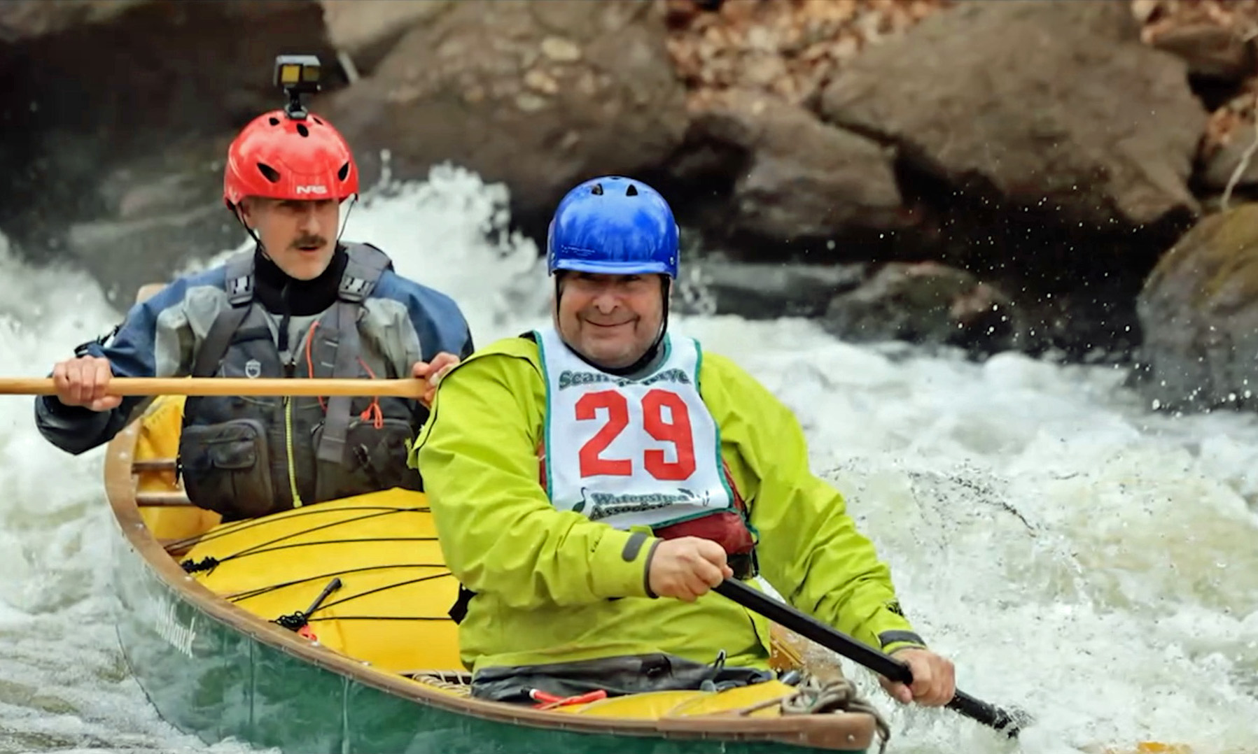
I’m not much of a canoe racer, but I’ve always loved watching the carnage at the Scantic Spring Splash Canoe and Kayak Race – especially the tandem canoes. I have run the Scantic many times in my solo canoes. This year I wanted to try a tandem run, so I partnered with Aaron for a run in my Mohawk Whitewater 16.

The Scantic arises in Hampden, MA (southeast of Springfield) and flows general southwest for 40-miles to join the Connecticut River in South Windsor, CT. We would be running the "Expert Course" from Quality Avenue in Somers to the Powder Hollow Barn on South Maple Street in Hazardville – about 5-miles. 

Competition takes a swim above Trestle
Much like RICKA’s old Branch River Race (AKA Rhode Island Whitewater Championship), the Scantic Spring Splash is a downriver race with four significant rapids. On the Branch the rapids are below the Harrisville Bridge, Whipple Drop, Glendale and Oakland. On the Scantic they are Trestle, Stokers, Chimney and Staircase. 

I dropped off my boat at the put-in and headed down to the barn to register with Aaron and pick up our bib. We got number 29. We then caught the shuttle bus back to the put-in. 

Running Stokers
After the mandatory safety meeting we got on the water at around noon with our class – Men's OC2 – Masters (AKA the “old fogey” group). There was only one other boat in our class, so we were guaranteed to place. We launched first and headed downstream. 

Even with the dam release the river was very low - .75-feet, 22 cfs on the Broad Brook gage. The race starts off with 2.5-miles of quickwater, and we scraped and bumped our way down the upper section. At one point we grounded on a gravel bar and got passed by our competition. The first of 5-times that the lead would change,  

Below Stokers
The removal of the Springborn Dam in 2017 created the first major rapid – Trestle. As we approached the rapid we saw our competitions swimming down the left side.  We went right, checked to make sure they were OK, and continued downstream. We were back in the lead. 

Shortly after Trestle is Stokers - a 3-foot ledge that needs to be run about 10 feet off the left bank. We ran the drop fine, but filled the boat up with water and needed to pull over to empty it out.  As we were emptying the boat our competition passed us again.

Running Staircase
We got back on the water and continued down some more quickwater. It wasn’t long before we saw our competition stuck on a gravel bar on the left.  We passed them to the right and were back in the lead. 

After some more quickwater we came to the next major rapid – Chimney.  It’s an “S-turn” through some rocky ledges that is run down the center. We made it through fine, but got hung up on a gravel bar at the bottom. Unfortunately, our competition grounded on the same gravel bar and blocked us in. They got back on the water first, so they were back in the lead.  

Staircase from the Bridge
We continued downstream to the last rapid – Staircase. It is exactly what you would expect - a series of ledges that look like a staircase with a large shoot at the bottom. We could see our competition out in front of us. At this point, our only chance to win would be if our competition swam the big drop at the bottom They didn’t, and neither did we.

It was fun paddling under the bridge at the finish line to the cheers of spectators above. We finished second in out class with a time of 57:19 - that was 32nd out of 55 racers. We hung around to collect our trophy at the awards ceremony before heading home.

Monday, April 29, 2024

White River - Stockbridge to Bethel - April 28, 2024

Running the Ledge Drop
First was Easter, then I got sick with the flu, then I had other family issues to deal with, so I didn’t do much paddling in April. Fortunately, I was able to catch Bob’s trip on the White River in Vermont.

The White River arises in the Green Mountains and flows south and then east through the hills and farmland of central Vermont before emptying into the Connecticut River at White River Junction. When the river is up there are miles of quickwater and easy rapids to enjoy. Two of the most popular sections are Granville to Stockbridge and Stockbridge to Bethel (Upper on American Whitewater). I had paddled the section from Granville to Stockbridge twice before (1, 2), so I was glad we would be paddling the section from Stockbridge to Bethel on this trip. The trip is around 11-miles, and I would be paddling tandem in my Mohawk Whitewater 16 with Bill.

Running the Ledge Drop
We needed to meet the group at the bridge over Route 100 in Stockbridge at 10:00, so Bill was at my house at 6:00 for the 3-hour drive up to the put-in. We had rain on-and-off as we drove through NH and VT, but it stopped by the time entered Stockbridge. We arrived at the put-in at about 9:45, and the rest of the group was ready to go. We quickly got unloaded and ran the shuttle down to Peavine Park in Bethel.

We launched at 10:45 and headed downstream with 9 boats – 1 tandem, 3 solos and 5 polers. This section of the river starts off much like the section above with quickwater and easy riffles. The river was a little on the low side at 5’, 1,500 cfs on the West Hartford gage – perfect for the polers, but a little low for the paddlers. Rock-dodging was the order of the day and w
e had to pick our lines carefully to avoid the shallows. 

Running the Ledge Drop
The river runs along Route 107 for almost the entire trip. 
We stopped for lunch just below the bridge at Blackmer Boulevard. There are two class II(+) rapids below the Blackmer Bridge – the first a rocky ledge drop that we ran to the left, and the second is a shoot with large waves that we ran center/right. From there it was more quickwater and rock-dodging down to the take-out.

With a long drive home ahead of us, Bill and I packed up our gear, said our goodbyes, and got on our way. The rain started up again just as we were pulling out – lucky us. There is also the Lower section below Bethel that I would like to try sometime.


White River from Erik Eckilson on Vimeo


Links:

Sunday, October 29, 2023

Halloween BBQ on the Piscat - October 28, 2023

The crew at the put-in
For 20-years the MVP and NHAMC have been sponsoring a Halloween Paddle and BBQ during the fall drawdown at the Gregg's Falls Dam on the Piscataquog River. I did my first whitewater trip here in 2005 after taking the NHAMC Whitewater School and purchasing my first whitewater boat, and have padded here many times since. This year would be the third time paddling tandem with Jonathan in my Mohawk Whitewater 16.

The Piscataquog River arise in Deering, NH and twists and turns for 35-miles before flowing into the Merrimack River in Manchester. We would be running the class II section below the Gregg's Falls Dam. I met Paul at the MacDonalds in Uxbridge for the trip up to Goffstown. As usual, I missed the exit in Manchester and we arrived late after taking the long way around the reservoir. Jonathan was already there, and Conrad and Ellen arrived shortly after.

Paul at Powerline
We dropped off our boats at the dam and ran the shuttle down to the road behind the prison. By the time we got back to the put-in there was a long line waiting to launch. The release was a little lower than usual due to issues with the dam – 5’, 700 cfs. The day was sunny and in the low 80’s – can’t beat that.

This section is about 3-miles long with the most consistent rapids in the first mile. The section just below the dam was a little boney at this level. Conrad and Ellen got hung up on the rocks, but Jonathan and I made it through fine. We did get into the big eddy for the surf wave below the power lines, but got flushed downstream before we could catch the wave. We did our best to turn the boat into a submarine at the surf wave above Henry Bridge, but didn’t swim!

Surfing the wave above Henry Bridge
From there is it mostly quickwater with a couple of easy rapids on the way down to the take-out. There is a squirt line where the river takes a sharp right turn. We pulled into the eddy, and got spun around on the strong eddy line. The last rapid is a rocky drop just above the take out. We got into the eddy on the left, but once again got flushed downstream before we could catch the surf wave.

After the run we headed back to the dam for the BBQ – hamburgers, hot dogs and good company. Great day as always.


Piscat Tandem Surfing - 2023 from Erik Eckilson on Vimeo.

Links:

Sunday, August 6, 2023

Lower Deerfield - August 5, 2023

That's me
Over the years, I’ve done a lot of trips on the Lower Deerfield. I can remember my first RICKA trip here with Jim Cole, Alan August and Henry Dziadosz back in 2006. I started leading RICKA trips here around 2010, and have done 10 “easy whitewater trips for flatwater paddlers” in the last 13-years.

The release from the Fife Brook Dam controls the water in this section of the river, and timing is everything with this trip. Launch too early and you will out run the water. Launch too late and the water will out run you. Either way, you will end up high and dry. Launching 3-hours after the scheduled release is about right. For this trip we had an early release due to Deerfieldfest, so timing wasn’t an issue.

Ozzie in Blam Dance
We would be running the section from the Zoar Picnic Area to Charlemont Academy – about 7 miles. The group was small since the trip coincided with RICKA's annual ADK trip. We had 5 boats and 6 paddlers (1 kayak, 1 poler, 2 solo canoes and 1 tandem canoe) - a nice size group for this run. Jonathan and I paddled tandem in my Mohawk Whitewater 16. Bob poled pretty much the entire run. The release was scheduled at 800 cfs, and the Charlemont gage was around 1,000 cfs.

We met at 11:00 at the take out near Chalemont Achademy and ran the shuttle up to the Zoar Picnic Area. As we prepared to launch, I was a little worried that that the bubble hadn’t made it down yet, but I felt better when a group of tubers from Great Outdoors showed up. We had plenty of water and would be dodging tubers for most of the run.

Bob poling Spin Out
This section of the Deerfield pretty much has it all. There is a little flatwater so you can take in the scenery, a lot of quickwater to keep you moving, and a couple of easy class I/II rapids to make it interesting. Most of the rapids come early in the trip with three easy rapids just downstream from the put-in.

Directly below the Zoar Picnic Area is the Blam Dance Rapid – we had one swim here when Jonathan and I were ferrying over and cut off Ed who was trying to peal out - whoops.

Dan at the top of Conjunction Junction
Below that at a the sharp curve to the left is the Spin Out Rapid. We rescued a tuber who was stuck in the recirculating eddy here, and had one swim when Ozzie was trying to surf the fast moving current.

To the left of the island with the squirt line at the bottom is Conjunction Junction. We took a break for lunch here. I took a swim, but it was intentional. Bob and Dan did a lot of surfing.

Bob poling at Conjunction Junction
After that, it is mostly quickwater with an occasional short rapid. I did my best not to dump Jonathan, but I did get him wet in the short wavetrain across from the campground near Shunpike. We had one more swim going into the eddy on the right in the fast moving shoot above Zoar Outdoors.

After the run, we decided to check out Deerfieldfest at Berkshire East. We were a little early, and there were more bikers than paddlers, but I did my part and bought and American Whitewater tee shirt. After a bite to eat we were on our way. Another great day on the water with a great group of paddlers.

Taking a break at Shunpike

Saturday, August 6, 2022

Fife Brook – August 6, 2022

Paul below Hangover Helper
It has been a while since I’ve been out in my whitewater boat, so I decided to test out my cranky knee and do a run with Paul on the Fife Brook Section of the Deerfield River.

I met Paul at McD’s for the ride up to Charlemont. After dropping him off at the put-in, I drove back to the take-out to drop off my car and catch a ride back in one of the shuttles. There were lots of groups getting organized, and I found an empty seat in a car with the CTAMC. It was Deerfieldfest weekend and the Dryway wasn’t running due to an issue with the dam, so there were crowds everywhere.  

Erik in Pinball
The Fife Brook Dam was releasing at 800 cfs – a medium low level. We put in at around 11:00 and began working our way downstream. The crowds at Hangover Helper and Carbis Bend were huge, but eventually we found some space to ourselves. We surfed the ledge below Freight Train and played in Pinball before taking a break for lunch at Miami Beach. We then ran the Island Rapid before heading down to Zoar Gap.

My record running the Gap is mixed - 15 attempts with 7 successful, 6 swims and 2 walks. I pulled over above the Gap to take some pictures before running it myself. Once in the Gap, I caught the eddy on the left below the first pour-over, and then went right of "Oh Shit Rock" though the second drop. It wasn’t pretty, but I made it. So my record in the Gap now stands at 16 attempts with 8 successful, 6 swims and 2 walks. My knee was fine.


Zoar Gap from Erik Eckilson on Vimeo.

Links:

Tuesday, September 29, 2020

Magalloway River and Lake Umbagog - September 25-27, 2020

Heading out from Wilson's Mills
Work has been crazy – so busy that I didn’t even start to pack for this trip until 8:00 the night before. Fortunately my ”kit” as Jonathan calls it is pretty self-contained so I quickly got everything together – I hoped.
 

I missed my spring camping trip this year due to COVID-19, so I was bound and determined to do something in this fall. Conrad was interested as well, so along with Julie we decided to paddle the Magalloway River down to Lake Umbagog, a short section of the Rapid River, and then down the Androscoggin to Errol. The trip was dictated by the availability of campsites. The State of NH campsites were closed, but Conrad was able to book the Northern Waters sites.


Covered Bridge at Aziscoos Valley 
I left my house at 7:00 to get to the put in at Wilson’s Mill by noon. It was sunny and warm when I left my house, but the clouds rolled in as I passed through the Franconia Notch. The leaves also got more colorful as I headed north.  

I passed the Village of Stark on the Upper Ammonoosuc and the 13-Mile Woods on the Androscoggin. The last time I was here was 2009 with the RICKA crew, but I also did my first whitewater run with my father on the Androscoggin back in 1990. As I passed through Errol I checked out the Errol Rips before heading up Route 16 to the put in at Wilson’s Mills.  


Canoes at Diamond Peaks
Conrad and Julie arrived around 1:00, and we ran the shuttle down to the dam in Errol. On the way back we stopped at the Aziscoos Valley Camping Area to buy some firewood. It would be a pain lugging firewood around, but it would also be nice not to have to forage for wood each day.

We got on the water around 3:00 for the 6-mile trip down the Magalloway to the first campsite. The Magalloway River flows south out of Aziscohos Lake to the outlet of Umbagog Lake where it forms the Androscoggin River. The upper section is a well-known whitewater run, but the lower section from Wilson’s Mills down is flatwater. It was cloudy as we headed downstream, but the foliage was still beautiful.


Beautiful foliage
We paddled under a pretty covered bridge at Aziscoos Valley Camping Area, and before we knew it we were at our first campsite - Diamond Peaks. It was a grassy and well-maintained site that gave us plenty of room to spread out. (Unfortunately, it is no longer a campsite available from Northern Waters.) We set up camp and got the fire going. It was nice not to have to go foraging for wood, because there didn’t seem to be a lot around. We cooked a late dinner and sat around the fire until 10:00 when we all turned in.

I woke up around 6:30 and got up to start the coffee. Conrad was up right behind me and got the fire going. Breakfast was the usual omelets with home fries.  We broke camp and were on the water by 10:00 for the 14-mile trip down to Cedar Stump on the Rapid River.


Sneak route to Lake Umbagog
It was a fast trip for the first 6-miles.  We took a break near Route 16 before paddling the last 2-miles down to Lake Umbagog. Big lakes tend to reveal themselves in the distance with a narrow foreground, a big void in the middle and a far-off background. That perspective then disappears, as you get closer. That’s the way it happened here.

After a mile or two of paddling the background disappeared but I came to a small channel with a view out to the lake – it looked promising, so that was the way I went. The lake opened up with beautiful views of the Presidential range to the east.


Mountain view from Lake Umbagog
Lake Umbagog is a pristine lake that forms the border between NH and ME. The lake is 11-miles long north to south, and about a mile wide east to west.  The lake is part of the Umbagog National Wildlife Refuge and Umbagog Lake State Park. There are 33 wilderness campsites on the lake operated by the State of NH, but unfortunately due to COVID-19 those sites were already closed for the season

We took a break at site 29, and planned out our route for the crossing. There were a pair of eagles sitting in a tree at a nearby island, but they were just out of camera range. We set out across the lake toward Pine Tree Point with a slight wind from the east and small wind blown waves. The views got better the further we got across the lake.


Breakfast fire at Cedar Stump
From Pine Tree Point it is about a 4-mile paddle across the top of Lake Umbagog and up a short section of the Rapid River. The Rapid River arises at Lower Richardson Lake and flows about 6-miles down to Lake Umbagog. Water from Rangeley Lake, Mooselookmeguntic Lake, and Upper and Lower Richardson Lakes all flows down the Rapid River into Lake Umbagog. The upper section of the Rapid River is another well-known whitewater run.  

We arrived at our Cedar Stump campsite to find a group of local fishermen using the group site for lunch. No problem – there were plenty of other sites across the river. Like Diamond Peaks, Cedar Stump has numerous sites so we were able to spread out. Once again we set up camp, got the fire going and settled in for a nice evening around the fire. Dinner was salmon and grilled vegetables cooked on the fire. After the 14-mile day we didn’t even last until 10:00.  


S-Turn rapid on the Rapid River
I woke up the next morning at around 7:00 and got up to start the coffee. Once again, Conrad was right behind me to start the fire. Breakfast was bacon, egg and cheese sandwiches with extra bacon. We decided to pack up early and then take a hike up the Rapid River to see the rapids.

According to Conrad the river was around 500 cfs compared to 1,800 cfs on a normal release day. Even at this low level the rapids seemed to be flowing at what we decided would be a technical class III.  We made it up as far as S-Turn Rapid before we had to turn around. On returning to camp, we packed up our remaining gear and got on the water around noon. 


The crew at the take out
The wind was blowing from the south as we headed out so we knew it would be an interesting crossing of the lake. As we came around Pine Tree Point we could see whitecaps and 1-foot rollers out on the lake. We headed out into the waves and made it across without too much difficulty. Once again, we stopped at site 29 for a break, and once again there was an eagle in the tree at the nearby island. This time I decided to head over to get some pictures, and the eagle cooperated. 

We cut through a channel into the Magalloway River and down a short distance to the headwaters of the Androscoggin. The Androscogin River flows 178-miles south and east to join the Kennebec River at Merrymeeting Bay where its waters empty the Gulf of Maine on the Atlantic Ocean. From here, it was a short paddle down to the dam in Errol and the end of our trip.  


Links: