Thursday, July 31, 2014

Fort Wetherill – July 31, 2014

Newport Bridge
I had worked my way through all my usual paddling spots in Narragansett – Point Judith Pondthe Harbor of Refuge, Pier 5, the Narrow River and the URI Bay Campus - so I decided to head over to Jamestown to paddle at Dutch Harbor.  I thought the water would be relatively calm, and I could get some pictures of the Dutch Island Light.

On the way over, I caught the sunrise over the salt marsh at Zeek's Creek and had some great views of the Newport Bridge. The only access to Dutch Harbor that I know of is at the town boat ramp at Fort Getty, and the guy at the gate wanted to charge me $30! So instead I drove down to Beavertail to see the Beavertail Light, and then went to Fort Wetherill. 

Beavertail Light
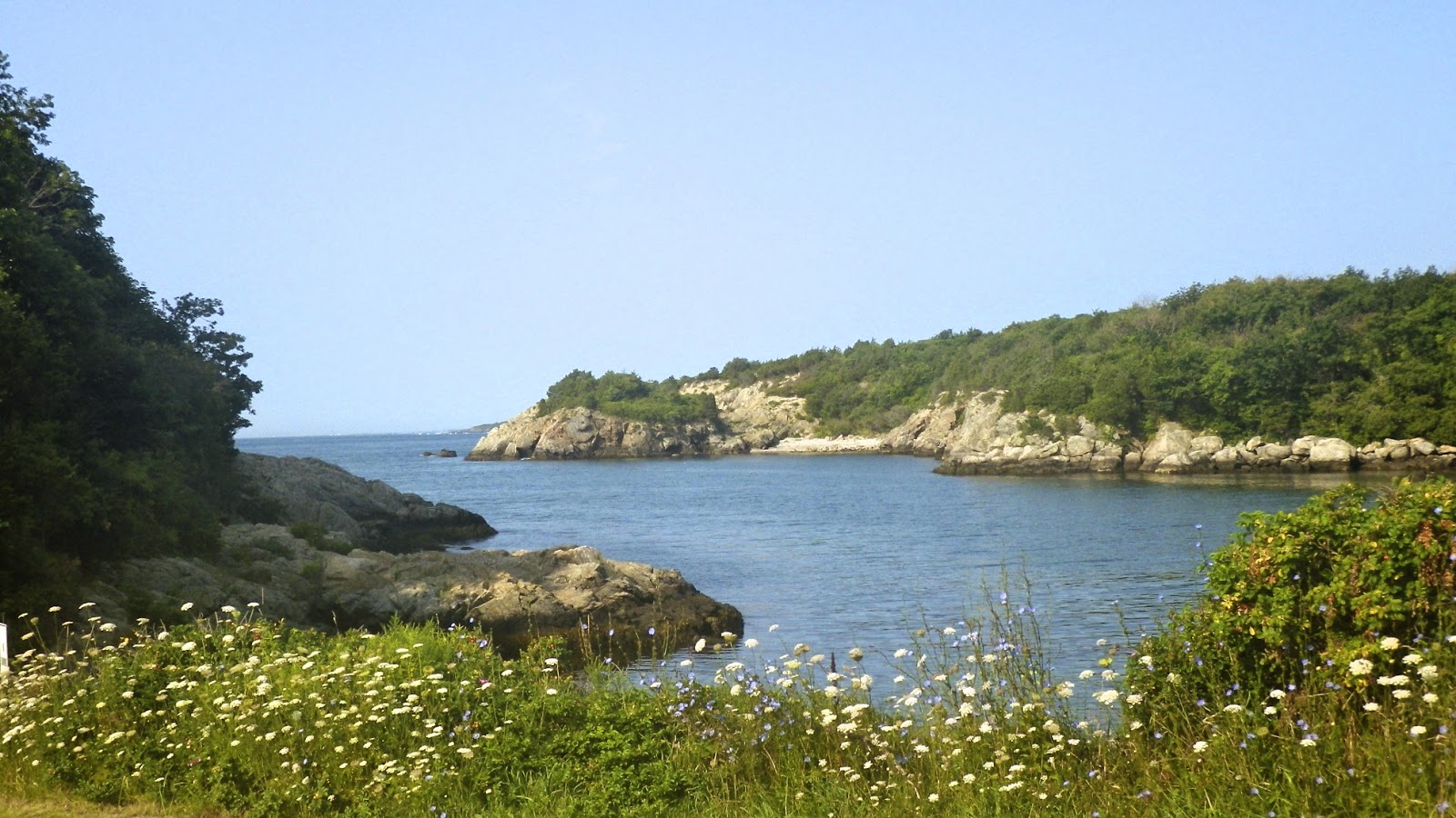
Fort Wetherill is former coastal defense battery and training camp located on 100-foot high granite cliffs across the East Passage from Newport and Fort Adams State Park.  I put in at the boat ramp at around 7:30 – high tide was around 11:30.  The paddle was great - 1 to 2 foot rolling waves, and absolutely beautiful scenery.

I know this is a popular spot for the sea kayakers, but flatwater paddlers (with the right skills and equipment) would love this trip as well (in the right conditions). 

View from the Put-in at Fort Wetherill
Links:

Wednesday, July 30, 2014

Saugatucket River - July 30, 2014

I paddled up the Point Judith Pond today to check out the Saugatucket River.  

The Saugatucket flows 8 miles from its origin in North Kingstown until it flows into Upper Point Judith Pond in at Silver Spring Cove in South Kingstown.  Like Pettaquamscutt Cove on the Narrow River, Point Judith Pond is a classic estuary where the Saugatucket River empties to the sea. Rhode Island’s other major salt ponds (Ninigret Pond, Green Hill Pond, Quonochontaug Pond, Maschaug Pond) are coastal lagoons. 

was able to make it up the Saugatucket about a mile to the Mews Tavern before low water and trees blocked my path.

Cormorant at the mouth of the Saugatuckett River
Links:

Tuesday, July 29, 2014

Harbor of Refuge - July 29, 2014

Fishermen on the Breakwater
I didn't get to paddle yesterday, so it was nice to get out today at the Harbor of Refuge.  

Construction of the Harbor of Refuge, which protects the Breachway and the Port of Galilee, began in 1890 with the construction of the east and west jetties.  The breakwater was not completed until 1910 with the completion of the center jetty. The Breachway that connects the Harbor of Refuge with the Point Judith Pond was completed in 1910, and the harbor at the mouth of the pond was dredged and a dock constructed in 1935 to create the Port of Galilee.

Even in the protected part of the harbor the waves were 2 to 3 feet.  I could see big waves breaking over at Point Judith, so I decided to go over and check them out.  The surfers were out in force.


Links:
My Pictures

Sunday, July 27, 2014

Port of Galilee - July 27, 2014

Lobster Boats
I decided to stay local this morning, so I paddled down Point Judith Pond to the Port of Galilee.  

With the Blessing of the Fleet yesterday, it seemed that most of the fishing boats were in port this morning. It’s an eclectic collection of large fishing trawlers, smaller lobster and shellfish boats and charter boats. Generations of fishermen have worked the waters of the Point Judith Pond, the Rhode Island and Block Island Sounds and beyond at the edge of the continental shelf. With the construction of the Harbor of Refuge and the stabilization of the Breachway, Galilee became the home port to this large, ocean-going fishing fleet.

I snapped some pictures before the clouds moved in and the rain began.

Fishing Boats in the Port of Galilee
Links:
My Pictures

Saturday, July 26, 2014

Sunrise at Pier 5 - July 26, 2014

I decided to go down to Narragansett this morning to catch the sunrise at Pier 5.  The colors seem to change by the minute.  

Sunrise at Pier 5 in Narragansett
Links:

Friday, July 25, 2014

Narrow River and Pettaquamscutt Cove - July 25, 2014

Kayaks at the point
The sun rose bright and clear as I headed out to paddle the Narrow River and Pettaquamscutt Cove.

It was high tide as I put in at the Sprague Bridge and headed down into the Narrows.  A small group in SOT sea kayaks had pulled over on the beach, but I decided to paddle out to check out the waves.  The water was calm immediately behind rocks, but one-foot waves were breaking over on the beach.  I paddled out to Cormorant Point before heading back up the river to Pettaquamscutt Cove.  

The osprey were in their nest at the bridge, but there weren’t many birds out in Pettaquamscutt Cove – probably because it was high tide.

Waves breaking at the mouth of the Narrow River
Links:

URI Bay Campus – July 24, 2014

Put-in at the URI Bay Campus
The sea kayakers seem to run a lot of trips from the URI Bay Campus, so I decided to check it out. 

The Bay Campus is at the site of the old South Ferry Village.  In the eighteenth century, this was a small port involved the trade of local marine and agricultural products.  By the nineteenth century, it had grown to be a thriving village.  All that remains of the old South Ferry Village today is the stone remnants of the old pier.

I put in around sunrise and paddled north toward the Jamestown Verrazzano Bridge.  Across the West Passage, I could see the Dutch Island and Beavertail Lights, and the Newport Bridge.  My original objective was to get a picture of the Plum Beach Light, but I wimped out when I saw how far out in the channel it was.

Jamestown Verrazzano Bridge
Links:

Around Ram Island – July 23, 2014

Wind surfer
The day started off cloudy and windy, so I decided to skip the early morning paddle to do some reconnaissance.  I drove up Route 1A to check out the put-in at the URI Bay Campus.  By the time I got back to the cottage the clouds were starting to burn off, so I decided to take my canoe out for a short trip around Ram Island. 

The water was calm and still as I headed up the east side of Ram Island.  As I rounded the tip the wind picked up, and I was paddling into a strong headwind with easy rolling waves.  A sailing class and small group of windsurfers seemed to love it.  For me, it wasn’t too bad until I turned to head back to the cottage across the pond.  With the wind now at my back, I did my best to quarter the waves, but it still took a while to get home.

Sailing class
Links:

Lower Point Judith Pond and Potter Pond – July 22, 2014

Horseshoe Point
I decided to paddle the lower section of Point Judith Pond around Great Island.  The water was flat and still, and the only noise was the sound of birds singing. 

I paddled down the east side of Great Island, under the bridge at Great Island Road, and into the Port of Galilee.  There were a bunch of cormorants hanging out at the mouth of the harbor, including three that looked like they were ready to catch a ride. 

Lighthouse at Snug Harbor
I paddled across the pond from Galilee to Snug Harbor.  I saw on the map in the cottage a connection from Point Judith Pond to another salt pond called Potter Pond.  I paddled up the inlet channel located between the marina and the lighthouse, under the Succotash Road Bridge, and into Potter Pond.

It’s a pretty pond that is about a mile from end-to-end.  I paddled about half way up when another osprey next caught my eye.    I headed back to Point Judith Pond, and got a few pictures of a sailing class before heading back t the cottage.

Osprey Nest on Potter Pond

Links:

Looking for Long Cove Again – July 21, 2014

I decided to take another shot at paddling into Long Cove.  This time I decided to paddle up through Upper Point Judith Pond and enter Long Cove from there. Once I finally found it, Long Cove was a bit of a disappointment.  The Long Cove Campground is located at the mouth of the cover, and it is not particularly attractive.  I did see another osprey next with osprey in it. As I paddled back to the cottage the sky was beginning t clear.  Looks like it is going to be a good day.

Horseshoe Cottage
Links:

Looking for Long Cove – July 20, 2014

Sunrise as Horseshoe Point
I’m on vacation in Narragansett, and the owners of the cottage we are renting have a nautical map of Point Judith Pond hanging on the wall.  It's there for decoration, but I immediately found a couple of places that I would like to explore.  The first is Long Cove.

We had passed by the sign for Long Cove Campground many times as we drove down Route 1, but I wasn’t sure where it was.  According to this map, Long Cove opens to the north end of the Upper Point Judith Pond.  A narrow strip of land separates it from Champlin Cove not far from our cottage. 

Egret as Champlin Cove
I paddled up the east side of Point Judith Pond along Ram Island and into Champlin Cove.  Unfortunately, a mucky marsh separates Point Judith Pond from Long Cove.  I probably could have made it through, but decided that I didn’t want to do get there that bad. 

Instead, I decided to explore the northwest corner of Point Judith Pond.  Birds were out in abundance – egrets, herons, cormorants and seagulls.  I also found two osprey nests – both with osprey in them.

Clamming boat at Ram Island
Links:

Sunday, July 13, 2014

Blackstone Gorge – July 13, 2014

Rolling Dam
I would have liked to see the Paddle Across Rhode Island crew finish the last leg of their trip, but I didn’t have time. So instead, I stayed local and paddled the section of the Blackstone River from the Blackstone Gorge to Millville. The water was so low below the Rolling Dam that I was able to walk across the river by stepping from rock to rock, and I never got my feet wet. 

Upstream from the dam is always a pleasant paddle.  I got out of my boat to explore the railroad bridges at the Triad Bridge site.  It is interesting that three railroads decided to cross the Blackstone River at this site – the Providence & Worcester Railroad, the New York & New England Railroad and the Grand Trunkline.

Millville Rapid
Just upstream from the Triad Bridge site is the old Millville Lock – one of only two remaining locks from the 1828 Blackstone Canal.  The other is the Goat HillLock at River Bend Farm.

I continued upstream to the Millville Rapid.  The water was low, but the rapid was runnable.  If it wasn’t for a tree limb blocking the shoot in the second drop, I probably would have tried.


Links:

Saturday, July 12, 2014

Paddle Across Rhode Island – Pawcatuck Camping – July 11, 2014

I drove straight from work to the Alton Dam so I could join the Paddle Across Rhode Island crew for at least one overnight on the river.  As I paddled out of the Wood River into the Pawcatuck River, it was great to see Chuck sitting on a rock waiting for me.  Actually, he was probably waiting for his cigarettes, but it was good to see him just the same.  Dave cooked fajitas for supper, and we sat around the campfire until it was time for bed.  The next morning, I cooked breakfast before the crew headed off on the next leg of their trip.
Cooking breakfast for the crew

Links:

Monday, July 7, 2014

Paddle Across Rhode Island – Manville Dam - July 6, 2014

I paddled out to meet up with the PARI crew as they approached the Manville Dam and visited with the Blackstone River Watershed Council at Sycamore Landing.  This was the first day of their eight-day trip across RI.  I hope to hook up with them again Friday night.


Links:

Sunday, July 6, 2014

A touch of Arthur - Biscuit City to Richmond - July 5, 2014

Running the fish ladder
at the Kenyon Dam
I wouldn’t say Hurricane Arthur was a bust, but it didn’t produce enough rain to bring the local whitewater rivers up.  The ones that were running were too far away, so Paul and I decided to do something local - the Pawcatuck from Old Biscuit City Road to Richmond.  Paul was looking for something with a little current, and he had never been on this section. 

The river was at a nice level – 3 feet, 300 cfs on the Wood River Junction gage.  We did a couple of laps at the Kenyon Dam fish ladder, portaged the Horseshoe Dam, and did a couple more laps at the Lower Shannock Falls.  From there it is basically flatwater to the Richmond Dam.

Half way down, Paul remembered that he forgot his keys in my car.  This is the third time that one of us had forgotten the keys – it's tough to get old.

Paul running Lower Shannock Falls

Links: