Saturday, June 29, 2024

The Bastille Day Campout - June 28-29, 2024

Home for the night
I was busy with work this spring, so I missed the spring camping trip with my usual camping buddies. Bill and I did try to get some interest going for a late spring trip on the Connecticut River, but everyone was busy. Rather than skipping camping completely, we decided on an old favorite – an overnight at the Burlingame Canoe Campsites on the Pawcatuck River.

Back in the old days, RICKA held an annual summer camping trip – the Bastille Day Campout. Bastille Day is a national holiday in France that celebrates the Storming of the Bastille on July 14, 1789. Why Bastille Day was chosen as a theme for a RICKA camping trip has been lost to history. The connection to summer is obvious, and maybe it was a simple as that. 

Campfire Paella for dinner
The event was originally held on Dutch Island. When the DEM prohibited camping on Dutch Island in 1991, it moved to the Burlingame Canoe Campsites on the Pawcatuck. It was celebrated with an assortment of French and French-Canadian delicacies – mostly wine and beer. A Molson toast around the fire was always the highlight of an evening filled with good food and good friends.

Reviving this RICKA tradition seemed like a worthy challenge, so Bill and I posted a trip on the flatwater message board, and we ended up with a group of six. We met at the Bradford Landing at 2:00 to load up our boats and paddle up to the campsites. There was one small complication - a large group celebrating a bachelor party had already set up camp at the Burlingame sites. Rather than intrude or put up with the noise, we decided to check out the bootleg sites along the river.  

The Molson toast around the fire
Danny and Bill headed out first, and checked out a site not far from the put-in. It was nice, but a little closed in, so we decided to check out some of the sites further upstream. Aaron suggested a site on river right just past the Burlingame sites. It had plenty of room for boats, a nice fire pit for cooking, and a great view of the river - the decision was made.

We hauled our gear up from the river and set up camp. Once camp was up, Aaron went out for a paddle, and the rest of us took a break to enjoy a few cocktails. Before long it was time to light the fire and cook dinner - campfire paella. After dinner, Dan, Aaron and I took a moonlight paddle up to the Burdickville Dam. Then we settled in around the campfire for the night. After many tall-tales and war-stories we finally turned in at around 10:00. 

Dan cooks breakfast
Before I knew it, morning light was streaming through my tent. I got up around 6:00, started the fire and got the coffee perking. Dan was up shortly after, so we started on breakfast. I fired up my Dutch oven to make a batch of cinnamon rolls, and Dan fired up his 20” Big Daddy skillet to cook everything else - bacon, home fries and eggs. No one ever goes hungry on these trips.

After breakfast we packed up camp for the trip back to Bradford. The sky was cloudy, and we even got a few drops of rain. Once there, we packed up the cars and said our goodbyes after another great tip. We will definitely have to put the Bastille Day Campout on the RICKA calendar next year.

Packed up and ready to go
Links:

Monday, June 24, 2024

Third Swim of the Year – Pawcatuck River – Bradford to Potter Hill - June 23, 2024

Bradford Fish Weirs
It rained as I drove down, but we ended up with a nice day for our trip on the Pawcatuck River. The last time that we did this trip was in 2020 during COVID, and back then we did a bike shuttle. No need for that this year.

The Pawcatuck River arises at Worden Pond in South Kingstown and flows southwest for 34-miles to Westerly where it flows into Little Narragansett Bay on Long Island Sound. Along with the Beaver, Queen - Usquepaug, Wood, Chipuxet, Shunock and Green Fall - Ashaway, the Pawcatuck received Wild and Scenic River status in 2019. We would be paddling the section from Bradford to Potter Hill – about 8-miles.

Polly Coon Footbridge
I met Bill, Paul, Bob, Aaron and Mike at the put-in at the Bradford Landing. We dropped off our boats and headed down to the take-out at Potter Hill. Parking is available at Post Office Landing – a DEM boat launch across the street from the take-out that is down a dirt road that looks like someone’s driveway. At least they have put a sign up now.

With all the rain over the past few days the river was at a nice level – 3-feet, 200 cfs on the Wood River Junction gage. We put in and headed down to run the Bradford Fish Weirs – a series of six gradually ascending stone steps that replaced the old Bradford Dam. Paul went first and ran the fish weirs clean. Bill and I went next. We hit a rock in the 4th weir, and over we went – 3rd swim of the year for me. Bob ran it last and made it through fine.

Marshland above the Potter Hill Dam
After the Fish Weirs, the river twists and turns through conservation land owned by the Westerly Land Trust and Hopkinton Land Trust. We passed under the Polly Coon Footbridge and continued downstream to the beach off Narragansett Way where we stopped for lunch. Below Route 3 there is more development as the river meanders through marshland formed by the deadwater of the Potter Hill Dam.

The take out is on the Westerly side of the river just above the Potter Hill Road Bridge at the Whiteley Preserve - a Westerly Land Trust property. We loaded up our boats and I drove Bill and Paul back to Bradford to pick up their cars. I forgot to bring my camera, but Mike got some great pictures and video.


Bradford Fish Weirs from Erik Eckilson on Vimeo.

We did earn another poem from Tom.

Bill seemed to hem and haw.
His stirring starboard would get them yawl.
Erik bowed to Bill’s stern grace.
Damp Bradford weirs on them in place.
TW

Links:
My Pictures and Video on Flickr
Mikes Pictures and Video on Facebook
Wood River Junction Gage

Monday, June 17, 2024

Rivers Day at Central Falls Landing - June 15, 2024

I spent Saturday at the RICKA booth at the Rivers Day Celebration at Central Falls Landing. Nice day, but not a lot of people at the event. Peter and I did take our boats out for a paddle up the Blackstone to the Pratt Dam, and it was nice that Paul and Fran stopped in for a visit.

Gary, Ron, Peter and Erik at the RICKA Booth at Rivers Day

Friday, June 14, 2024

Thursday Night Tville - June 13, 2024

The crew
Spring will soon be turning to summer, and I had yet to get out for a Thursday night Tville run on the Farmington River with the CT/AMC. With temperatures in the 80’s (first trip in shorts and a tee shirt), I decided that this would be the day.

The Farmington River arises near Otis, MA and flows generally south and east for 47 miles through Connecticut until it reaches the Connecticut River near Windsor, CT. There are several sections of the Farmington that are popular for whitewater boating – New Boston (class III/IV), Riverton/Satan’s Kingdom (class I/II), Crystal (class II), and of course “Tville” or the Tariffville Gorge (class II/III).

Cathy's Wave
Tville is one of the best-known whitewater runs in southern New England. It is the site of an annual spring slalom race, and has hosted national and Olympic trials. The run itself is short - just 1.5 miles, but the water runs most of the year and there are play spots for paddlers of all skill levels. At yesterday’s level – 1.5 feet, 550 cfs - it is more of a class II run, at least the way I run it.

We met at Tarrifville Park and ran the shuttle down to the take-out at Taxis Avenue. We had 13 in our group, and met up with 6 more along the way. There was plenty of water at Cathy’s Wave and Brown's Ledge. I ran the Bridge Abutment Rapid first and got some pictures of the rest of the group coming through.

Typewriter
As usual, I ran the rapids above the Play Hole to the left, and got out to get some video of folks surfing. It was cool to watch Kieth in his C1. Below the Playhole are three ledges that I run to the left. I did get some pictures of folks running the bigger drop on the right. I headed down to Double Drop behind Erin. It looked like she was going center, so I took my normal line to the right.

As I approached the drop, I could see Erin’s kayak upside-down right in the center of my line. She had flipped in the hole and was in the process of rolling back up. Fortunately, I was able to sideslip further to the right to avoid running her over. After I passed, Erin rolled up no worse for wear. We did some surfing at Typewriter before heading down to the take-out.


C1 Playboating at the Tville Play Hole from Erik Eckilson on Vimeo.

I posted this video on canoetripping.net, and Glenn MacGrady posted this remembrance of the old days at the Tville Play Hole.
There was a time when the line of boaters playing in the Tville hole every weekend and often during the week included no C1s and only a rare kayak—but just open canoes. It was where I learned to ride surf, side surf, slide surf, spin surf, and use cross strokes for downstream bracing. There were, of course, no three dimensional aquabatics in an open canoe, but some paddlers could and did roll open canoes in the Tville hole. Sue Burgess used to stand on the gunwales of her Blue Hole OC-A while side surfing in the hole, and then lower herself and rotate her body 180° upside down until she was headstanding on her seat, all while still on a balanced side surf.
Maybe I need to get back in the hole and practice.

Links:
My Pictures
River Description from American Whitewater
Tville Gage

Sunday, June 9, 2024

Paddling Zoar Gap over the Years

Zoar Gap has changed again. There have been three different versions of the "Gap" since I started paddling in 2006. Back in the old days I always took the easy "sneak" route on the far right. That went away with Tropical Storm Irene in 2012, and I usually eddied out at the top and tried to go right (or left, with mixed success). After last year's flooding things got moved around again and the left line got a lot easier. Here are some of my runs over the years:


My Gap record now stands at 18 attempts with 10 successful, 6 swims and 2 walks.

Pride Day On the Deerfield - June 8, 2024

The crew at the put-in 
It was a day to show support LGBTQ+ folks, and to encourage everyone to get out and paddle. Who wouldn’t want to do that. Besides, it has been a while since I’ve done a run on the Fife Brook Section of the Deerfield River, so I was glad when Paul posted this trip on RICKA’s whitewater message board.

Deerfield River arises in southern VT and flows for 76-miles through VT and MA to join with the Connecticut River in Greenfield below Turners Falls. With over a 1,000-foot drop, hydroelectric development began in 1910 when the New England Power Company was formed to acquire water rights and build hydroelectric dams. There are now 10 dams on the Deerfield operated by three different electric utilities. An innovative licensing agreement with these dam operators requires lots of recreational releases for whitewater paddling, rafting and tubing.

Hangover Helper
There are several sections of the Deerfield that are popular for whitewater paddling. Advanced paddlers often head to “The Dryway” in Monroe Bridge. This is a class III-IV section of river for experienced whitewater paddlers. RICKA has several paddlers who paddle the Dryway, but I’m not one of them.

We would be paddling the Fife Brook section, which is named for the Fife Brook Dam that controls its flow. It runs 9-miles from the dam down to the Shunpike Rest Area in Charlemont. It is mostly class II, with the exception of Zoar Gap in the middle which is class III. Since Pride Day is always a popular event we knew the river would be crowded.

Carbis Bend
I picked up Paul at 7:00 and we headed off to the river. It takes a couple of hours to get there, so it’s always nice to have someone along to share the ride. We arrived at the put-in at the Fife Brook Dam at around 10:00. Craig and Elliot were already there. We arranged the shuttle, and by 11:00 we were on the river.

The day was cloudy and windy with a few drops of rain. Temperatures were in the 60’s, so it was tough to know what to wear. I brought my wet suit with a slash top. Paul wore his dry suit. Both were good choices. The Fife Brook Dam was releasing at 800 cfs, and the gage in Charlemont was between 800 and 900 cfs.

Freight Train
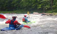
Just downstream from the put-in is the first rapid known as “Hangover Helper”. At this rapid, a ledge extends across most of the river resulting in a 2-foot drop followed by a long wave train. If you’re still asleep, or perhaps a little hung-over, this rapid will wake you up fast. We ran the drop and played in the waves before moving downstream.

The next rapid - “Carbis Bend” - is similar but smaller. A ledge extends out from the left side of the river producing a couple of easy surf waves. Even those too timid to try surfing at Hangover Helper will generally give it a try at Carbis Bend, so it’s a popular place to stop.

Surf wave below Freight Train
Just downstream from Carbis Bend is a rapid known as “Freight Train”. This rapid starts with a long wave train and ends with a large surf wave. The rapid takes its name from the speed that many people build up running through the waves, and the railroad bridge just downstream that carries freight trains across the river.

After Freight Train is a rock garden known as “Pinball”. With scattered rocks and ledges, it’s a great place to practice eddy turns, peel outs and ferries. After Pinball is the Island Rapid. As the name describes, the river is split by an island. The usual route is to the left with large waves and fast moving water where the river reconnects at the end.

Island Rapid
After the Island Rapid comes Zoar Gap – the largest rapid on this section of the river. Zoar Gap has changed several times over the years. When I started paddling back in 2006 there was an easy sneak line on the far right. That went away with Tropical Storm Irene in 2012, and I usually eddied out at the top and tried to go right (with mixed success). After last year's flooding the left line got a lot easier. We all went left yesterday, and made it through fine.

After the gap, Craig and Elliot headed home, and Paul and I continued downstream to the Shunpike Rest Area. With the wind at our back it was a quick run. We stopped for sub’s on the way home at Georgio's Pizza in Greenfield. It’s a long ride, but for such a great day, it’s worth it.

Erik and Craig running Zoar Gap
Links:
My Pictures

Wednesday, June 5, 2024

Manville Dam – June 4, 2024

It was nice to get out on the Blackstone Valley Paddle Club trip on the Blackstone River above the Manville Dam. We made it up as far at the boat ramp at Rivers Edge Park.  Nice night, not a lot of pictures, but a nice video from Aaron.

Video clips from Aaron Rouby's 360-degree camera

Monday, June 3, 2024

Planning for Spring Camping - Connecticut River - Bloomfield to Guildhall

I was getting worried that I wasn’t going to get out on a spring camping trip this year. so I sent an email to Bill to see if he would be interested in a short trip on the Connecticut River. We decided on a three-day, two-night trip the last week in June, which actually makes it a summer trip. Close enough - Luther’s Troopers will be out again!

Here is the plan:

June 27th - Leave early and put-in at Debanville Landing – mile 348. A unimproved path at the mouth of the Nulhegan River - park by the Northern Forest Canoe Trail kiosk on the other side of Rt. 102.  
44° 45' 5.2344" N71° 37' 58.6524" W

June 27th - First Night at Maine Central Railroad Trestle Campsite (VT) – mile 341. A beautiful campsite maintained by the Northern Forest Canoe Trail. The site is immediately downstream of granite railroad trestle, on the Vermont side.  
44°40'34.0"N 71°35'33.1"W

Intermediate Take-out - Maidstone Bridge – mile 336. Cartop access on New Hampshire side, down river of bridge.  44° 39' 6.354" N, 71° 33' 44.3232" W

June 28th - Second Night at Samuel Benton Campsite (VT) – mile 334. The campsite is situated in a grove of trees on a sandy bluff, at the edge of a field, on privately owned farmland - we stayed here in 2017.  44° 37' 46.362" N, 71° 32' 50.3196" W

June 29th – Take-out at Guildhall/Wyoming Dam – Mile 323. Take-out is located immediately upstream on the Vermont side. A portage trail takes paddlers up to Rt. 105.  44°33'50.8"N 71°33'33.1"W

This is part of the trip that I did with Bill, Tommy and Mena back in 2017. I have the two sites are booked in the Campsite Registry of the Connecticut River Paddlers Trail. 

Bill and I on the Connecticut River in 2017
Link:

Sunday, June 2, 2024

Manville Dam – June 2, 2024

Went down to the Manville Dam to check out the put-in in advance of Tuesday’s Blackstone Valley Paddle Club trip. I picked up whatever trash I could fine. Then I spent a little while carving circles in my whitewater boat.

River Island Park – June 1, 2024

It’s been a while since I had my whitewater boat out, so I decided to do a park-and-play run at River Island Park. River was at the perfect level – 3-feet, 1,000 cfs – nice waves to surf everywhere. I was a little rusty, but it came back.