Monday, December 12, 2011

Blacskstone River - Plummers Landing to Route 16 - December 12, 2011

Rice City Dam and the Hartford Avenue Bridge
I’m trying to use up the last of my vacation time, so I was glad when Paul said he would be able to paddle this morning. We decided to paddle the Blackstone from Plummers Landing (Church Street in Northbridge) the Stanley Woolen Mill (Route 16 in Uxbridge).

We met at the take out on Route 16 across from the Stanley Woolen Mill at 9:00 and ran the shuttle. It was a nice sunny day, but a little cool. There was a thin layer of ice on the Blackstone Canal, and an occasional icicle on the river - winter is coming.  The river was at a nice level – 4.5 feet, 600 cfs. on the Northbridge gage.

At this level, this trip is mostly quickwater with some flatwater through the Rice City Pond and one portage around the Rice City Dam at Hartford Avenue. We cruised downstream with little effort allowing the current to do most of the work and having a good time maneuvering though the frequent “S” turns.

We finished up around 11:00 – just in time for me to get to the Museum of Work and Culture for rehearsal.

At the put-in at Plummers Landing
Links:
Blackstone River Gage at Northbridge
Plummers Landing from the BRVNHC
River Bend Farm from the BRVNHC

Sunday, December 4, 2011

Blackstone River Videos

This year, I added a few new videos to my collection of Blackstone River videos. I now have the river pretty much covered from Riverbend Farm in Uxbridge down to the Slater Mill in Pawtucket. I also included a couple of sections of the Clear/Branch Rivers. Anyway, here they are:

Riverbend Farm – Canal/River Loop (new)
Uxbridge – includes Rice City Pond, Goat Hill Lock and the Stanley Woolen Mill
http://vimeo.com/25340897

Route 16 to the Blackstone Gorge
Uxbridge, Millville and Blackstone – mostly the Millville Rapid
http://www.vimeo.com/12182627

Blackstone Gorge to the Millville Rapid (new)
Blackstone and Millville – includes the Millville Lock and the Triad Bridge
http://vimeo.com/25607298

Blackstone Gorge (new)
A hike up the Blackstone Gorge
https://vimeo.com/76258312

Canal Street to the Blackstone Gorge
Blackstone and North Smithfield – includes the Branch River
http://www.vimeo.com/13609047

Branch River (new)
Forestdale to Slatersville – includes the Slatersville Mills
http://vimeo.com/25907741

Branch River
Harrisville to Slatersville – whitewater paddling
http://vimeo.com/8208159

Saint Paul Street to Canal Street
Blackstone - Poling
http://www.vimeo.com/12702312

Cold Spring Park to the Woonsocket Falls (new)
Woonsocket – paddling in the rain
http://vimeo.com/27409569

River Island Park and the Woonsocket Falls
Woonsocket - Poling
http://www.vimeo.com/13968407

Manville Dam
Cumberland and Lincoln
http://www.vimeo.com/12515578

Albion to Ashton (new)
Cumberland and Lincoln
http://vimeo.com/26225004

Canal River Loop – Lonsdale to Ashton (new)
Lincoln – includes Blackstone Canal and Ashton Dam
http://vimeo.com/22232656

Lonsdale to Manville
Cumberland and Lincoln through Ashton and Albion
http://www.vimeo.com/11954675

Valley Falls to Lonsdale
Cumberland and Lincoln
http://www.vimeo.com/15111785

Valley Falls to the Slater Mill
Cumberland, Central Falls and Pawtucket
http://www.vimeo.com/13233037

I still need to get the upper sections of the Blackstone from Worcester down to Uxbridge – maybe next year.

Saturday, December 3, 2011

Sure beats working - Clear and Branch Rivers – December 2, 2011

Paul below the Harrisville Dam
It’s been a beautiful week, and I have some vacation time that I need to use, so I sent an email to Paul to see if he would be interested in an afternoon paddle. We ended up on the Clear/Branch River yesterday.

The Clear/Branch is a fun run that I haven’t done in a couple of years. It’s about 7.5 miles with a little bit of everything – a lot of flatwater, some quickwater and a couple of easy rapids. It’s the only river in Rhode Island listed in American Whitewater.

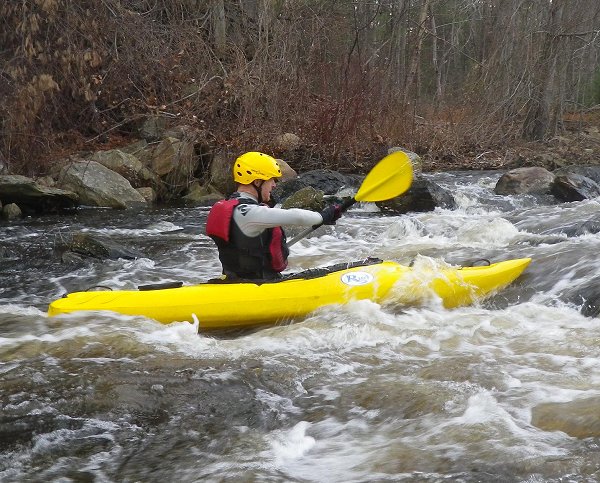
Erik below the Whipple Drop
It was sunny and warm when we got on the river at around 1:00 in the afternoon. The river level was 3.5 feet, 300 cfs. on the Forestdale gage - OK, but another foot of water would have been better. We put in below the dam in Harrisville at the East Avenue Bridge (Route 107). The first rapid is directly below the bridge where two rows of boulders make for a difficult line through a small drop. We both took the bumpy route, but made it through fine, and headed downstream.

After about a short section of pleasant flatwater, we came to the next rapid – Whipple Drop. This is an old broken dam that creates about a 2-foot drop with a large rock just downstream. In high water, the current tends to sweep boats into this rock. At yesterday’s level it was an easy run just left of center. We played in the waves for a little while before continuing downstream.

Old Oakland Mill
After a couple miles of easy flatwater, we came to the first portage at the Oakland Dam. Remnants of the old Oakland Mill still stand on the left. We portaged on the right. Below the Oakland Dam, the river is mostly quickwater.

About a mile downstream we came to the Glendale Rapid. In high water, this is a rocky class II rapid. At yesterday’s level, it was boney, but not particularly difficult. I got hung up on a rock in the middle, got swung around, and finished the rest of the rapid backwards. Paul made a clean run down the middle.

Paul below Atlas Pallet
We played in the waves below the Glendale Rapid and enjoyed about a mile of quickwater before coming to the next rapid – the broken dam at Atlas Pallet. This is a short class II rapid with a couple of large boulders to avoid, and some easy surf waves at the bottom. We both ran the rapid clean, and after surfing in the waves, headed back downstream.

We portaged the Nasonville dam on the right and paddled the easy flatwater down to the take out off Nasonville Road. By this time, the sun was low in the sky, and both of us were starting to get cold. I blasted the heat as I shuttled Paul back to his car. Another great day.

Links:
My Pictures
River description from American Whitewater
Branch River Gage at Forestdale

Saturday, November 26, 2011

Day after Turkey Paddle – Lower Millers – November 25, 2011

After eating way too much on Thanksgiving, it was good to get out yesterday to burn off some calories. We ran the lower section of the Millers River in Erving, MA – 2 canoes (Ed and Erik) and 3 kayaks (Andy, Brian and Glenn).

This was my second time on the Lower Millers, and it is a great run. The river was at 4.3 feet which turned out to be a nice level - nothing technical, just lots of long wave trains. The most difficult rapid on this section is called the Funnel, and we looked at it long and hard before we decided to carry. The holes weren't as big as last time (4.7 feet), but there were a lot more rocks exposed.   I swam this rapid last time, and had to hike downstream about a half mile to recover my boat. I didn’t want to do that again.

Surfing a wave below the Funnel
Links:
My Pictures
My Video
Erving Gage
Running the Funnel - center left line by Adam Attarian on 1/19/15 @ 4.2 feet

Sunday, November 20, 2011

Nipmuc River - November 20, 2011

I had hoped to do the Branch River today, but it didn’t work out, so I headed up to the fishing area in Harrisville to paddle the Nipmuc River. I’ve done this trip several times before, so I knew there would be beaver dams and downed trees. The river was at 3.7 feet, 30 cfs. - not a bad level.

As I approached the first beaver dam I could see it was in great shape. It had a fresh layer of sticks and mud, and was holding back 2 to 3 feet of water. The beaver lodge just up stream also had a fresh layer of sticks and mud, and had a large collection of sticks nearby – perfect for a winter snack. The beavers had been busy.

I paddled upstream, thought the fields and into the marshy woods. This is where we usually end up turning back due to fallen trees, but I decided to keep going upstream. I paddled around a couple fallen trees, and had to get out and carry over a few more.

I continued upstream to the USGS gage where the river enters a beautiful hemlock forest. The river was shallow, and eventually, I had to get out and walk. I walked upstream another mile, wading around boulders and up several small rocky drops. It was beautiful, but unfortunately, I forgot my camera back at the car.

I’d definitely like to do a run down this section of the river when there is more water.  Paul says that the put in is off Brook Road in Burrillville and that it is good above 4.5 feet.

Links:
Nipmuc River Gage near Harrisville

Monday, November 7, 2011

Nashua River - Leominster to Lancaster - November 6, 2011

Had a good time yesterday on the North Branch of the Nashua River. We had 7 boats – 5 canoes (Tommy, Mike, Jim, Doug and Jeff) and 2 kayaks (Bill and Scott). I brought my poling boat, but ended up paddling tandem with Jeff in his Appalachian.

It was the first time for me on the Nashua River. We paddled the section from Leominster (Searstown Mall – Rt. 2 and Rt. 13) to the Lancaster (Ponakin Bridge - Rt. 70 in Lancaster just north of Rt. 117). The river was at a nice level – 380 cfs, almost 4 ft on the Leominster gage. This section of the river is especially nice where it runs through the Johnny Apple Seed State Park and the Lancaster State Forest. It is mostly flatwater with some quickwater and a couple of broken dams. The first broken dam was probably a class II yesterday with a 3-foot drop into a large hole at the bottom.


Nashua River from Erik Eckilson on Vimeo.

The second at the power lines was probably class I with a nice surfwave.

Captain Mike at the Power Lines
Links:
My video
North Nashua River Gage near Leominster, MA

Friday, November 4, 2011

Canoe Poling - the other side of canoeing

Stand tall and carry a canoepole
There is an old saying that you should never stand in a canoe. The people who say that have obviously never heard of canoe poling. Instead of sitting with a paddle, you stand and use a long pole to move the canoe. Poling makes it easy to push upstream, move slowly through difficult rapids, or slip across shallow water.

Poling started with the wilderness trippers of northern Maine, but it definitely has a following around here. I am fortunate to have a group of friends that likes canoe poling. The best boat for poling is a tandem tripping canoe - 16 to 18 feet long, with a 32 to 36 inch beam. Canoepoles are usually about 12-feet long. They are traditionally made of wood, but can also be aluminum

Floating down calm water
To get started, find some shallow water where you can get the feel of standing in your canoe. Stand just aft of center. Keep your head over the center of the canoe, and feet shoulder width apart. Use your legs as shock absorbers, bending at the knees and hips as you rock your canoe back and forth.

Once you feel comfortable standing in the canoe, it is time to start on forward movement. The easiest skill to learn is the windmill stroke. Grip the pole in the center with both hands and alternate paddling from side to side like a kayak stroke. You can also practice turning the canoe with forward and reverse sweeps on both sides of the canoe.

Pushing upstream
Once you feel comfortable with that, you ready to push. Stand just aft of center with your feet shoulder width apart. Drop the pole so it is firmly planted on the bottom, a few feet behind where you are standing. This will put the pole between a 30 to 45 degree angle from vertical. With your offside hand on top, slide your hands up as high as you can on the pole. Then begin to lower your body weigh as if you were going to sit in a chair, at the same time start pushing your pole straight back. You will feel the canoe move forward. To recover the pole for another push, move the pole up with your top hand as it slides through your bottom hand.

Now it is time to apply your new skills to moving water. The trim of your canoe is very important when traveling upstream. Stand slightly aft of center to lighten the bow and weight the stern. The canoe will act like a weather vane helping to maintain a straight course.

Snubbing downstream
Going downstream you remain in control by using a technique called snubbing. Instead of using the pole to move the boat forward, you use it as a brake to slow or even stop your descent. Again, trim is important and you will want to move forward to lighten the stern and weight the bow when snubbing. With the pole out in front, use the pole to slow your decent, using your arm as shock absorbers. As the current rushes pasts, you will be moving downstream slowly and with precise control.

Poling can be hard work and a little frustrating at first, but before you know it, poling will become second nature. So get out there, grab a pole, and discover the other side of canoeing.

A poling cruise in the Farmington River
Links: