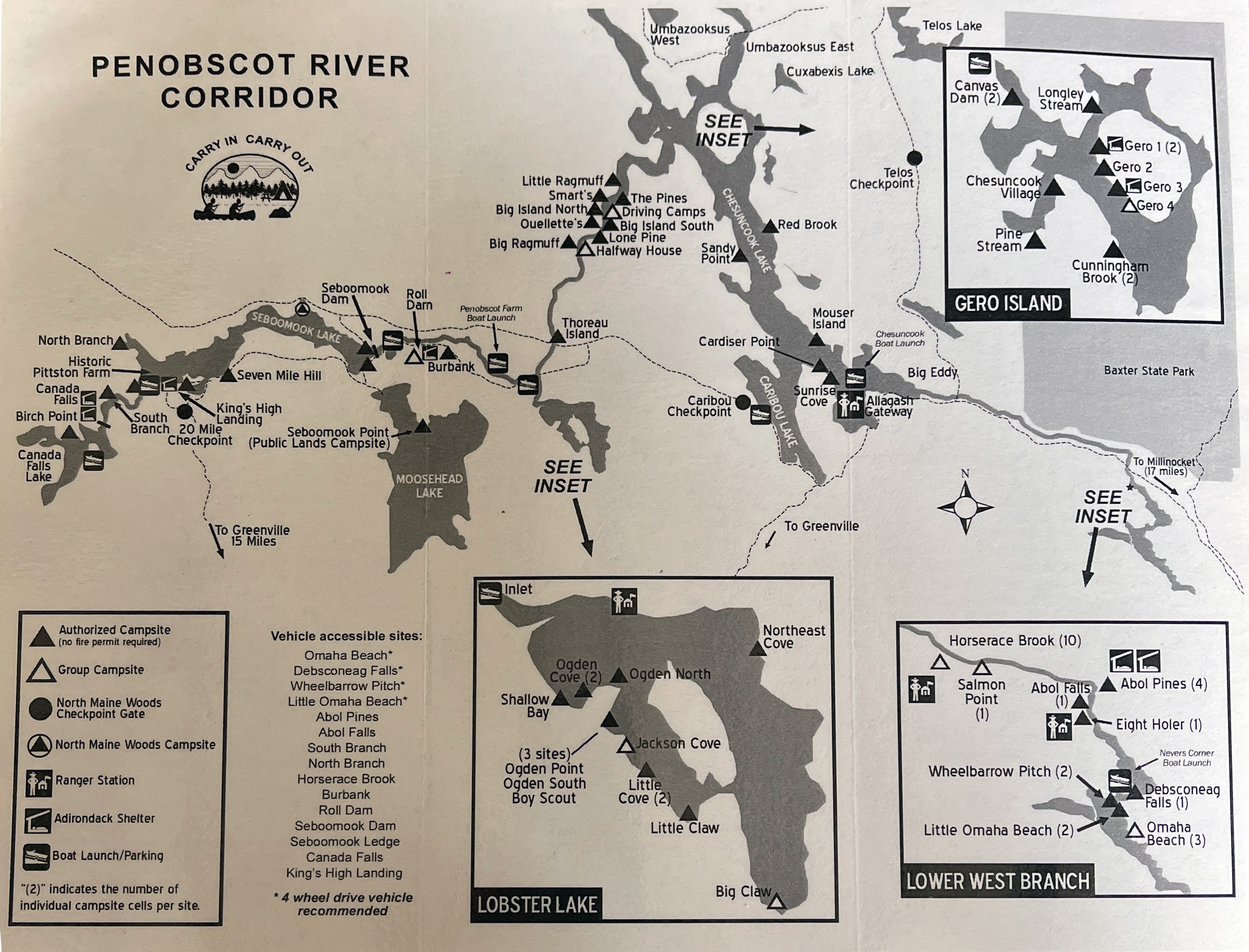
Sunday, March 22, 2026

Branch River Icebreaker - March 21, 2026

Heading downstream
As a nod to all the years that RICKA ran the Branch River Race, we always try to run the Branch River on the traditional third weekend in March. We call it the "Branch River Icebreaker", but there hasn’t been any ice to break for the past few years.

The Branch River Race, later the Rhode Island Whitewater Championship, was established by RICKA in 1980. It was the first race of the year on calendar of the NECKRA Downriver Series. The race continued for 25 years, but was eventually discontinued due to the high cost of insurance and problems with river access.

Running Whipple Drop
RICKA has continued the tradition of running a spring trip on the Branch River race course. This year we had three boats with four paddlers - me, Chuck, Mike and Aaron. The river was at a nice level - 4-feet, 400 cfs. The day was mostly sunny and relatively warm - it felt like spring.

We met at the put-in below the Stillwater Mill at 10:00 to run the shuttle. Since the usual take out along Nasonville Road is now posted “No Trespassing”, we decided to take out at the state boat ramp on the Slatersville Reservoir.

Running The Glendale Rapid
We put in and paddled up to the Harrisville Dam before heading downstream. The first half of this trip is actually on the Clear River. There were a couple of blow downs in this upper section, but nothing that we had to portage around.

We ran Whipple Drop down the center and continued to Oakland, where the Branch River is formed at the confluence of the Clear and Chepachet Rivers.

Weaving through the strainers
After a break for lunch at the Oakland Dam we headed down to Glendale. The Glendale Rapid was flowing well. We all took the line generally left of center. I went a little too far left and had to back paddle off the rocks near the shore.

From there it is a nice quickwater run down to the Atlas Pallet Rapid. There were a lot of strainers in this section including one that we had to portage, and one that we ran but probably should have portaged. Aaron lost is camera twice, but was able to recover it both times.

Running Atlas Pallet
I ran the Atlas Pallet Rapid left of center and made it through fine. I got some pictures of Chuck, Aaron and Mike running the right of center line. The surf wave at the bottom wasn’t very retentive, so we continued downstream.

We portaged the Nasonville Dam and bounced out way down the rest of the easy rapids to Victory Highway. From there it is mostly flatwater as we paddled into to the Slaterville Reservoir to the take out.

The crew at the Oakland Dam - Chuck, Mike, Erik (kneeling) and Aaron
Links:

Sunday, March 15, 2026

Bigelow Brook – March 15, 2026

Heading out from the put in
With the recent rain and snow melt, Mike put a trip on the whitewater message board for Bigelow Brook. It would be rare chance to do a natural flow run on this very pretty Connecticut river. The last time Mike ran it was about 10-year’s ago.

Bigelow Brook arises at the Mashapaug Lake in Union and flows generally south/southeast through Bigelow Hollow State Park, Bigelow Pond and Myers Pond. It then forms the border between Ashford and Eastford before joining the Still River to form the Nachaug River. We would be running the section from Westford Road to the Natchaug State Forest.

Below the Route 44 Bridge
I met Mike and Aaron at the commuter lot at the intersection of Routes 44 and 198 in Eastford to run the shuttle. We put in at Westford Road and headed downstream. The river twists and turns through pretty woodlands lined with Hemlock trees and Mountain Laurel. It is mostly quickwater with some easy class I/II rapids – the largest being under the Route 44 Bridge. Dodging rocks and staying in the deepwater channel was the order of the day.

We continued downstream past the confluence with the Still River and on to the Natchaug River. We took out at the Natchaug State Forest – about a 6-mile trip. The gage on the Natchaug River above Diana’s Pool spiked at about 1,000-cfs last week, and was about 300-cfs today. There is no gage on Bigelow Brook itself.

Taking a break at the confluence
Links:
My Pictures

Thursday, March 12, 2026

Assabet - Maynard - March 12, 2026

Surfing below the ben Smith Dam
Rain and warm weather brought all the rivers up this week. When Dan told me about a trip on the class II section of the Assabet through Maynard, I decided to take the day-off and join in.

The Assabet River arises in Westborough and flows approximately 34 miles west to converge with the Sudbury River at Egg Rock in Concord to form the Concord River. There’s lots of great flatwater paddling on the Assabet including the section from Gleasondale to the Ben Smith Dam, and from the PowdermIll Dam down to Egg Rock. The section through Maynard is an easy class II with a couple of rapids at the bridges, and some nice surf waves by the Ben Smith Dam and along Walnut Street near the mills.

Center arch of the Mill Street Bridge
In 1847, textile manufacturer Amory Maynard purchased land in what is now Maynard from a farmer named Ben Smith and built a dam to power his textile mills. Originally known as Assabet Village, this became the town of Maynard in 1871. Maynard’s downtown textile mills, now Clock Tower Place, were the home of Digital Equipment Corporation from the 1960’s to the 1990’s. Digital was a major computer company with 140,000 employees in 1987.

I met Dan, Ozy, Rick and Bob on Taft Avenue to run the shuttle. The river was at a nice level – 4-feet, 650 cfs on the Maynard gage. We played in the waves below the Ben Smith Dam before heading downstream. There are six bridges over the Assabet River as it flows through Maynard. The first is the double arch Great Road Bridge. Either side is runnable, but we went to the left. A pipe runs along the downstream end producing a surfwave that can be caught from the left side.

Above the Walnut Street Bridge
The next bridge is the triple arch Mill Street Bridge. We ran the center arch, cutting to the left after the bridge to avoid the rocks in the middle. After some easy riffles comes the Florida Road Bridge. The river then turns right along Walnut Street and the mills. If you can catch the small shore eddies, there are a couple of nice surfwaves before you reach the Main Street Bridge.

Downstream from the Main Street Bridge, the river turns left as it goes under the Walnut Street Bridge. There are a few more riffles and one more substantial rapid as you approach the Waltham Street, which we ran to the left. With my sore knee, I only did one run. The cortisone shot helped, but it still hurt to kneel.

Links
My Pictures
River Description from American Whitewater
Maynard Gage

Sunday, March 8, 2026

Noon Hill - March 8, 2026

Foggy as we headed out
Temp’s are warming and the rivers are starting to ice out, but with my sore knee I decided to join Papa Joe for his hike at Noon Hill in Medfield, MA.

Noon Hill is a Trustees of Reservations property with a prominent summit and scenic vista surrounded by 204-acres of open space. It offers 4.5 miles of hiking trails and is part of a larger network of open space that includes the Shattuck Reservation along the Charles River. A system of trails spans the two properties, some of which are part of the Bay Circuit Trail.

Selfie with the crew
It was a foggy morning as we headed out from the parking lot at 158 Noon Hill Road in Medfield. We followed the yellow trial to the red trail to the top of Noon Hill. At 370-feet, Noon Hill rises gently above the surrounding landscape giving great views to the southeast of neighboring Walpole and Norfolk.

From there the followed the red trail back to the yellow trail as we looped back to the parking lot. Distance was only 3-miles, but with the partially frozen snow, the footing wasn't the best.

The crew at the summit of Noon Hill
Links:
My Pictures
Noon Hill Reservation
Shattuck Reservation

Sunday, March 1, 2026

Planning for Spring Camping - West Branch of the Penobscot/Lobster Lake

I got an email from Jonathan looking to start planning a spring camping trip. We are thinking about the West Branch of the Penobscot in May. 

The classic trip is to put in below Roll Dam and paddle about 7-miles to Lobster Lake. Spend a night on Lobster Lake. From Lobster Lake, paddle 15-miles to Chesuncook Lake. Check out Chesuncook Village and then paddle 19-miles down the lake enjoying the great views of Mount KatahdinWe are not planning anything that ambitious. Here is our plan - 5 days, 4 nights, very leisurely pace:
  • Tuesday, May 19th - assemble in Wiscasset for dinner.
  • Wednesday, May 20th - travel to Chesuncook Village to drop cars - shuttle to Lobster Trip. Paddle to Lobster Lake - Ogden Cove camp site (2.7-miles).
  • Thursday, May 21st - stay on Lobster Lake and explore.
  • Friday, May 22nd - paddle back to the river and then on down to a camp site, maybe Thoreau Island (13-miles).
  • Saturday, May 23rd - paddle down river to Pine Stream camp site - very nice, easy day (6-miles).
  • Sunday, May 24th - paddle to Chesuncook Village (4-miles). Load vehicles and drive to Wiscasset (185-miles) for showers, dinner.
  • Monday, May 25th - Memorial Day - head home to beat the traffic.
For the shuttle we will try Katahdin Outfitters. According to Jonathan, the road to Chesuncook Village was pretty good when it was new back in 2012. It is about 13-miles from the Chesuncook Village to the Golden Road which is itself usually pretty good. Here we go again with logging roads in the North Maine Woods - hope my tires hold out.