 |
| Covered Bridge in Sheffield |
My
springtime trip on the Housatonic got me thinking that this would be a great river for a weekend camping trip. I decided to do a
fall foliage trip with
RICKA paddling the flatwater sections from Sheffield, MA to Ashley Falls, MA on Saturday, and Ashley Falls, MA to Falls Village, CT on Sunday.
The
Housatonic originates in the Berkshire Hills of western MA and flows south for 150 miles along the western border of MA and CT before emptying into Long Island Sound. There’s lots of great paddling along the Housatonic River. The best-known whitewater section is a
class IV run known as Bulls Bridge - it's well above my skill level. There is also the quickwater section from
Cornwall to Kent that I have run several times.
 |
| Paul on the first log pile |
Bill and I headed out on Friday to check out the put-ins and take-outs before heading over to the campground at
Tatonic State Park in NY. As we checked out the put-in at the Covered Bridge in Sheffield a guy on a bike rode up and asked us if we'd seen any tingleys. “What are tingleys?” we asked. “They are UFO’s” he said. Apparently this was the site of a famous
UFO sighting back in the 1960’s, but there were no UFO sightings or alien abductions on our trip.
When we arrived at our campsite we found Jim Cole waiting for us. He had made the 1,400-mile drive from FL to NY to join us - how’s that for determination. I originally wanted to stay at
Housatonic Meadows State Park in CT, but it was closed for the season. None of us had stayed at Taconic State Park before, but it turned out to be perfect. We had 11 campers for Friday and Saturday nights, and a few even stayed through Columbus Day.
 |
| Portaging the broken dam |
On Saturday, we did the 9-mile trip from the Covered Bridge on Covered Bridge Lane in Sheffield, MA to Rannapo Road in Ashley Falls, MA. In addition to 11 campers, we had 3 who came out to run this section as a day trip. The river was high –
4.7 feet, 2,500 cfs. on the Falls Village gage, after peaking at 6 feet, 4,000 cfs. on Wednesday. The higher water was a blessing and a curse. A blessing for the fast moving current, and a curse for the steep, slick banks and soggy lunch spots.
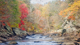
We put in at the Covered Bridge and headed downstream. The river twists and turns through fields and meadows along the foothills of the Berkshires. There was some nice color, but we probably missed the peak foliage by a couple of weeks. The trip was uneventful except for two river-wide log-jams that we had to portage, and a tough hill to climb at the take-out.
 |
| Jim below the broken dam |
After the trip, Bill and I took a detour to check out
Bash Bish Falls – the tallest waterfall in MA. We then returned to the campground for a nice potluck supper around the campfire. The food was plentiful and the conversation was great.
On Sunday, we did the 11-mile section from Rannapo Road in Ashley Falls, MA to the Great Falls Dam in Falls Village, CT. This trip begins where Saturday’s trip ended, so we once again had to deal with the steep hill at the put-in. The river had dropped slightly to
2.2 feet, 1,500 cfs. We still had good current but the banks were still slick and our lunch spot was still soggy.
 |
| Take-out at Great Falls |
The main feature on this section of the river is the broken dam in Canaan. Supposedly the rapid on the right side of the island is runnable, but it would have been difficult to scout, so we all portaged on the left. Once again, a steep bank at the end made for a challenging portage, but we managed fine.
From there it is about 5-miles to the take-out at the dam at Great Falls. We snapped a group picture and checked out
Great Falls before heading out from another great trip.
Housatonic Foliage Weekend from Erik Eckilson on Vimeo.
Links:


