Sunday, August 24, 2025

Fife Brook in my Millbrook Outrage - August 22, 2025

Running Zoar Gap
I knew I was going to have a busy weekend, so when a saw a post for a Friday afternoon trip on Fife Brook I decided to join. This would be the first whitewater run in my new Millbrook Outrage, and I got Paul to come along as well.

We met at 12:30 at the take out below the Gap. I was surprised how many people were around for a weekday trip. We had 11 in our group – 4 canoes and 7 kayaks – and there were 3 other groups organizing to get on the river. The release was 800 cfs – an OK level, but a little boney in spots.

Running Zoar Gap
We got on the water at around 1:15, and I could tell right away that the composite Outrage was different than its Royalex cousin. It’s hard to describe, but it made the Royalex version feel a little sluggish. The composite boat was definitely faster, the turns were crisper, and it was really dry. I've always admired the Millbrook guys who were bailing out their boats with sponges – now I know why.

We worked out way downstream, and the boat felt more comfortable the more I paddled it. When we finally got to Zoar Gap I was the last one to go through. I caught a couple of eddies on the left on the way down, and the two big rocks on the right before heading in. I took the line from right to left, and made it through fine. 

Running Zoar Gap over the Years

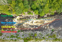
Routes through Zoar Gap over the years
There have been three different versions of the "Gap" since I started paddling in 2006. Back in the old days there was an easy "sneak" route on the far right (red). That got filled with rocks during Tropical Storm Irene in 2012. After that, I usually eddied out at the top and tried to go right or left of "Oh Shit Rock" in the middle of the second drop, with mixed success (yellow going right). After flooding in 2023 things got moved around again. The eddy at the top got squirrely, the right line got blocked by rocks, but cutting directly from right to left got a lot easier (blue). There has always been a kayak line of the far left (green). Here are some of my runs over the years:


My Zoar Gap record now stands at 21 attempts with 13 successful, 6 swims and 2 walks. I’ve made it through successfully on my last 5 runs.

Wednesday, August 20, 2025

Slatersville - August 20, 2025

I had a nice night with the Blackstone Valley Paddle Club at the Slatersville Reservoir. I paddled tandem with Cheryl. We put in at the State Boat Ramp and paddled up the Branch River until it got too shallow.

Saturday, August 16, 2025

Lincoln Woods Again - August 16, 2025

I have my grandson’s birthday today, and a visit to Rehoboth and my brother’s cookout in NH tomorrow, so there will be no paddling trips for me this weekend. I did get out this morning for a quick trip to Lincoln Woods in the Millbrook. It felt good on flatwater, but I need to get it out on some whitewater - maybe Fife Brook next week.  

Thursday, August 14, 2025

Planning another Allagash trip

I'm planning another Allagash trip with Jonathan in September - this time with Bill and Dan. As usual, we'll do five nights on the river with a spare/layover day to explore the lakes. Here’s the schedule:
  • Sunday, September 7th - assemble at Jonathan’s in Wiscasset in time for dinner.
  • Monday, September 8th – leave Wiscasset early for the 5-hour drive to Churchill Dam - camp at the Jaws.
  • Tuesday, September 9th - spare day to explore the lakes – another night at the Jaws. I would love to get down to Eagle Lake to see the locomotives if the putt-putt is working - 20-mile round trip.
  • Wednesday, September 10th – run Chase Rapids - camp at the Ledges on Umsaskis or Jalberts on Long Lake.
  • Thursday, September 11th - Long Lake Dam (portage) - camp at Inlet or Outlet on Round Pond.
  • Friday, September 12th - Round Pond to Five Finger Brook - camp at Five Finger Brook or Cunliffe Depot. I wouldn’t mind seeing the log haulers at Cunliffe Depot again.
  • Saturday, September 13th – early start down to Michaud Farm to meet Norm L’Italien (Pelletier’s Campground) for the ride back to Churchill Dam. Drive back to Wiscasset for dinner, or the long drive home.
We'll paddle tandem in Jonathan's Explorers. We’ll bring coolers with real food for as long as possible. Lunches and drinks are BYO. Jonathan will bring cooking gear and G&T for the 6:30 sundown meeting. Everyone will bring their own chair, camping gear, coffee mug, and other refreshments. We'll have to figure out who’s doing what for meals, and the remaining group gear.

The last time we were there the river was between 2,500 and 3,000 cfs. Today it is at 451 cfs - about what it was when we were there in 2022

Hopefully they will get some rain.

Monday, August 11, 2025

Dead - Spencer Stream to West Forks - August 9, 2025

The boats get loaded
There are rivers that aren’t too difficult if you take the right lines, but can be brutal if you don’t. I was on one of these rivers on Saturday – the Dead in ME, and I paid the price for a bad line on the last rapid - Lower Poplar. My first swim of the year.

The Dead is one of the longest continuous whitewater runs in the Northeast with approximately thirty rapids along a fourteen-mile stretch. The river is mostly boulder-type rapids with lots of holes and pour-overs. The shoreline has thick vegetation that grows right up to the river's edge that can make it difficult to rescue swimmers or bail out an open boat. The major named rapids are:
  • Spencer Rips –big weaves are to the right, big eddy below on left to stop and regroup.
  • Minefield (2 miles) – long boulder garden with big waves and lots of holes – difficulty increases where the river turns left.
  • Hyden’s – (3 miles) good lunch spot – run in middle and stay out of holes.
  • Gravel Pit (4.5 miles)
  • Enchanted Stream (7 miles) – another good lunch spot.
  • Elephant Rock – (7.5 miles) a river wide ledge immediately below Enchanted Stream. You can run the big waves in the center, or the slot on the right between Elephant Rock and the rock wall.
  • Mile Long (8.5 miles) – another long boulder garden with big waves and lots of holes. There is an eddy on the left about half-way down
  • Upper Spruce Ledge (10.5 miles)
  • Lower Spruce Ledge (11 miles)
  • Upper Poplar Falls (11.5 miles) – short but intense rapid filled with rocks and holes. Go right and stay away from holes – stop in big eddy bottom right.
  • Lower Poplar Falls (12 miles) – a longer intense rapid that tumbles down the left side in huge wave trains and large holes. Left is hero line with lots of dangerous holes. The right line along the boulder garden is the usual open boat route.
Heading out
I picked up Paul for the six hour drive up to the Forks. We stayed in a two-person cabin-tent at Northern Outdoors. We had a small fire on Friday before settling in for the night.

We were up early Saturday morning to meet our group and the shuttle. We were paddling with the Penobscot Paddle and Chowder Society - aka the Chowder Heads. We had a group with 13 boats – 6 canoes, 6 kayaks and 1 shredder.

Charlie in one of the unnamed rapids
Old-time Dead River paddlers probably remember Webb’s Shuttle Service run by Ed Webb. Webb's (later Riverdrivers) no longer provides shuttle service, so we met the new shuttle company - Ironbound Outdoors - at 8:00 at the Public Takeout on Dead River Roar in West Forks.

With the large group of MVP'ers running the Dead for a step-up weekend, it took forever to load the boats. We finally got on the road around 9:30, and got to the river about 45 minutes later after a long, bumpy, dusty trip down 20-miles of dirt logging roads. We finally got on the water around 11:00.

Paul running Lower Poplar
The release was supposed to be 2,400 cfs, but was closer to 2,100 cfs with 25 cfs from Spencer Stream - a nice class II/III. At lower levels (1,200 cfs to 1,800 cfs) it is primarily class II except for the very first, and last couple of rapids. At medium levels (2,000 cfs to 3,500 cfs) it is mostly class III. At higher levels (4,500 cfs to–8,000 cfs) it is class IV.

We ran through Spencer Rips, Minefield and some other unnamed rapids before stopping for lunch at Hayden's. Then we ran Hayden's, Gravel Pit and some other unnamed rapids before taking a break at Enchanted Stream. Paul wanted to get some video so I ran the big waves in the middle of the ledge at Elephant Rock rather than the shoot on the right.

Erik running Lower Poplar
The next major rapid was Mile Long – another long boulder garden with big waves and lots of holes I filled my boat about half way down, but was able to empty it in a big eddy on the left before finishing the rapid. After running the Upper and Lower Spruce Ledges we took a break at the Poplar Portage Trail before taking on Upper and Lower Poplar.

Upper Poplar is a short but intense rapid filled with rocks and holes. Most of us ran it to the right and made it through fine. Lower Poplar was another story. The river turns right along a boulder garden as the water tumbles down the left side in huge wave trains and large holes.

Swimming Lower Poplar
Most of the open boats took the right line along the seam between the boulder garden and the big holes. As I was coming down I saw Charlie flip in front of me. I got around him to the left, but now I was  out in the big holes and pour-overs. Before long, my boat was full of water and I was struggling to keep it upright, never mind avoiding the rocks and holes. About half way down, I went sideways over a large rock into a hole, and over I went.

As I swam downstream I looked back to see my canoe still stuck in the hole. That was the least of my problems. Swimming through rapids is something that I try to practice, but it doesn’t match the real experience. First, I swam though a series of “haystacks” or standing waves where you have to breathe in the trough, and hold your breath as you go through the wave - breathe, glug, breathe, glug, breathe, glug.

Reunited with my boat at
the bottom of Lower Poplar
After the waves, I could see a horizon line downstream indicating that I was approaching a rock with a hole on the other side. I tucked into a ball as best I could as I went into the hole. When I came out the other side Paul was yelling at me to swim hard to the left shore since I was approaching another big hole. I wasn’t making much progress so I threw away my paddle thinking that would allow me to swim better. After more waves, rocks and holes, I finally got myself to shore. It was about a 200-yard swim, but it seemed like forever.

After I caught my breath I looked over and could see Paul on the other side of the river with my boat. I was about to jump in the shredder for a ride to the other side when Craig paddled over towing my boat. I had paddled through 30 rapids over 14-miles only to swim the last 200-yards. We had 3 other open boaters swim Lower Poplar, so I guess I shouldn't feel too bad. 


The swim earned me a new poem from Tom.

It’s really not an Outrage,
until one’s stood on end.
But chill we will baptised beginning,
again, again, again.

If that ol’ paddler’s adage, “Ya ain’t really learnin’ unless yer gettin’ wet,” holds any water, we’re gonna have t’call ya, Doctor Dunk, Erik.

Man’s gotta do what a man’s gotta do.
TW

Thursday, August 7, 2025

Lincoln Woods - August 6, 2025

I got up early, and got out to paddle my new Millbrook Outrage. I started out on flatwater at Lincoln Woods. It is great at spinning and carving turns, but like all whitewater boats, it can be a bit of a challenge to paddle straight. After that I headed over to River Island Park to paddle in some current, but there wasn’t enough water to do much. I’m off to the Dead this weekend with Paul, but I’m going to bring my Mad River Outrage. I want to spend a little more time in this new boat before taking it on a big trip like that.

Wednesday, August 6, 2025

Providence - August 5, 2025

Under the I-way Bridge
With most of the crew up in the Adirondacks, I agreed to lead the Blackstone Valley Paddle Club Trip on the Providence River.

The Providence River is formed at the convergence of the Woonasquatucket and Moshassuck Rivers in downtown Providence. It flows south through Providence for a mile to its convergence with the Seekonk River at Bold Point/India Point. It then opens up into Providence Harbor and continues south for 8-miles to the narrows between Conimicut Point in Warwick and Nayatt Point in Barrington where it becomes Narraganset Bay.

Skyline from Water Street
We had a group of 14 boats – all kayaks, although Danny joined us at Water Street in his canoe. It was high tide when we put in at Bold Point and headed out across Providence Harbor towards the Fox Point Hurricane Barrier. We passed the tugboats and paddled under the I-way Bridge and through the hurricane barrier into downtown Providence.

Providence was established in 1636 by Puritan theologian Roger Williams who was fleeing religious persecution in Boston. It became a trading center in the 18th century, a manufacturing center in the 19th century, and a financial center in the 20th century. This history can be seen today in the warehouses, mills and office buildings that line the river.

Skyline from the Cove
In the heart of Providence the river passes through Waterplace Park. Completed in 1994, Waterplace Park includes pedestrian bridges over the river that connect over a mile of cobblestone-paved walkways known as the Riverwalk. The park is home to the popular summertime Waterfire events

We continued up the Woonasquatucket River into the Cove at Waterplace Park. We paddled under Providence Place before turning around, and had a leisurely paddle back through the city.


Links:

Tuesday, August 5, 2025

Millbrook Outrage - August 4, 2025

I’ve finally joined the Millbrook club! I just bought a lightly-used Millbrook Outrage – coincidentally from the same guy who owed my old Encore. This is the second boat that I have in both royalex and composite versions - Wildfire/Yellowstone Solo and now the Outrage.

Millbrook Boats is known for lightweight and durable composite whitewater canoes. The company was founded by John Berry in 1959 and initially focused on whitewater slalom boats. In 1988, John Berry sold the business to John Kazimierczyk. Kaz expanded the market for Millbrook Boats to recreational paddlers with boats like the 20/20, the Shacho and others.

In 1995, Mad River Canoe introduced the Outrage, which was designed by Tom Foster and Jim Henry. Specifications are:
  • Length: 12'
  • Gunwale Width: 28"
  • Depth at Center: 15.5"
Kaz received the mold for the Outrage from Jim Henry in 2015 and has made about 25 boats with it. Based on the hull identification number (EJQOUT02C156) this is the second Millbrook Outrage built in 2016. The first is owned by Rick Howard. The color scheme on my boat is called Magma to represent glowing and cooling lava.

Interestingly, the royalex version from Mad River is an inch shorter and a quarter inch narrower than the Millbrook composite boat - maybe the royalex has shrank a little over the years. Both of mine were outfitted by Kaz and came with 8" pedestals. I raised the Mad River by 1/2" to 8 1/2" - still a little low for me. I raised the Millbrook by 1" to 9", which seems better - we'll see.

Saturday, August 2, 2025

Two Weeks on Salt Water - End of Another Great Vacation

Taking a break at East Matunuck Beach
Our annual summer vacation at the beach ended today, so packing up to go home trumped paddling this morning. With family, work and weather I missed a few days of paddling, but that’s OK. I was still able to get out to most of my favorites including Potter Pond, the Harbor of Refuge, Jamestown Harbor, the Narrow River and Wickford. I missed some old favorites like Dutch Harbor and Fort Wetherill. Of course, I spent a lot of time paddling on Point Judith Pond including another fun trip with RICKA.

Thursday, July 31, 2025

Around Ram Island - July 31 2025

Denny and Ann’s grandnephew Zach is visiting from the UK and I offered to take him out kayaking. Denny and Zach used the kayaks from the cottage. The wind was gusting, but we still spent an hour paddling around Ram Island.  

Wickford - July 31, 2025

The Castle
My first choice today was to paddle at Dutch Harbor, but it was fogged in. Instead, I headed over to Wickford to paddle Wickford Harbor. 

Wickford was established in the early 17th century when Roger Williams purchased land from the Narragansett Indians and established a trading post. In 1637, Williams sold the land to Richard Smith who constructed a large fortified house on the site, giving the house its nickname the “Castle”. That house was burned during King Philip's War, and the structure that can be seen from the put-in today was built in 1678.

Wickford Shipyard
Wickford grew to become a major port and shipbuilding center, and today contains a large collection of 17th and 18th century homes. It is a picturesque village whose streets are lined with shops and restaurants, and whose harbor is filled with sailboats and yachts.

I paddled out from Wilson Park into Mill Cove, then around Cornelius Island into Fishing Cove, and then out to the breakwater. From there I paddled around the outer harbor before returning to Wilson Park. 

Breakwater at Wickford Harbor
Links:

Wednesday, July 30, 2025

Harbor of Refuge - July 30, 2025

Point Judith Light
I need to have just the right conditions to paddle around the breakwater at the Harbor of Refuge, and this morning I did - clear skies, calm winds, low tide at 6:00 a.m. and swells of just 1-foot. It doesn’t get much better than that.

Even after construction of the Point Judith Light (c. 1810/1857) conditions remained treacherous at the tip of Point Judith and a Federal project was initiated to construct over 3-miles of jetties to provide a secure breakwater refuge for shipping. Work began in 1890 with construction of the east (3,640 feet) and west (2,240 feet) jetties, and was completed in 1910 with construction the V-shaped center jetty (6,970 feet). A 1,500-foot opening was left for the east passage, and a 1,200-foot opening was left for the west passage.

Holes at the "V" in the center jetty
While the jetties were originally constructed to provide a refuge for ships traveling between Boston and New York during bad weather, they also protected the newly constructed Port of Galilee. In 1910, the Town of South Kingstown and the State of Rhode Island dredged the current Breachway and stabilized it with stone jetties. Then, in the 1930's, the State of Rhode Island dredged an anchorage basin just inside the Breachway and built wharves to create a port for large, ocean-going fishing vessels. This allowed the Galilee to become one of the largest fishing ports on the east coast

I lugged my boat and gear across the beach at Camp Cronin and launched at around 6:30 a.m. I was amazed how much damage was done by last year’s winter storms. The navigation tower at the east end of the center jetty was completely destroyed. Huge boulders were pushed aside leaving large gaps in the seawall, even at low tide. It's hard to imagine that water can move those huge rocks. I paddled by the cormorants and other shore birds resting on the seawall out to the tip of the "V" in the center jetty before heading back.


East end of the center jetty before and after the winter storms of 2024
Links:

Monday, July 28, 2025

Jamestown Harbor - July 8, 2025

Newport Bridge in the fog
It was foggy this morning, so I decided to head over to Jamestown to paddle around Jamestown Harbor and get some pictures of the Newport Bridge. I put in at the East Ferry Boat Ramp and headed out into the harbor.

The Newport Bridge was completed in 1969 and is the longest suspension bridge in New England. It spans the East Passage of Narragansett Bay from Jamestown to Newport. The main span is over 1,600 feet long, and the road deck is more 200 feet above the water. The towers themselves are over 400 feet tall.

Clingstone or the "House on the Rock"
I followed the boat moorings down to the Dumplings - a grouping of rocks just off Bull Point. The most prominent of the Dumplings is Clingstone or the "House on the Rock". This massive post and beam home was built in 1905 and has been recently restored.

It turned out to be a nice morning with nice calm conditions. The fog burned off to hazy sunshine by the time I finished.

Newport Bridge from the Dumplings
Links:

Sunday, July 27, 2025

Port of Galilee - July 27, 2025

The kids are visiting this weekend, so I decided to stay around the cottage and paddle down to Galilee. I paddled down the east side of Great Island into Bluff Hill Cove and then into the Port of Galilee.

The Port of Galilee was created in 1935 when a harbor was dredged and a dock constructed at the mouth of Point Judith Pond. Connected to the ocean by the Breachway and the Harbor of Refuge, both completed in 1910, Galilee eventually became the home port for much of Rhode Island's fishing fleet. I paddled past the fishing trawlers, lobster boats and charter boats before heading back. I forgot to bring my camera, but here is a picture from last year

Buoy in the Port of Galilee

Saturday, July 26, 2025

Point Judith Pond with RICKA - July 26, 2025

Paddling by the osprey nest
This year my annual Point Judith Pond trip for RICKA coincided with the Blessing of the Fleet in Galilee. This is usually a flatwater trip, but since there was no sea kayak trip on the calendar, I posted in the sea kayak board as well.

Point Judith Pond, or the Great Salt Pond, is located along the border of Narragansett and South Kingstown, and is the second largest of the Rhode Island’s South County salt ponds. It is a shallow, four-mile long pond located behind the barrier beaches and sand dunes that form Point Judith. The pond is 20 miles around with many pretty islands and coves to explore.

Group picture form the cottage
We met in Marina Park at the hand-carried boat ramp next to the Point Judith Yacht Club at 10:00, and were on the water by 10:30. We had 7 boats – all kayaks, and a nice mix of flatwater and sea kayak paddlers. Winds were from the north, but switched to the east later in the day

We headed out into the Upper Pond from Marina Park, paddled through the Narrows and out into Point Judith Pond. We checked out the osprey nest at Billington Cove and explored the islands and coves in the upper Point Judith Pond before heading to down to Gardner Island where we crossed the boat channel.

View from the top of the Breachway
We paddled past Beach Island and across the top of Ram Island before paddling down the east side of Ram Island to Great Island. Michelle came out and snapped a few pictures before we headed to the east side of Great Island to Galilee.

It was a little after 12:00 when we paddled into Galilee. We stayed out the boat channel and paddled down to the last red buoys above the Breachway. With the tide going out, the current kept pulling us down into the Breachway. We saw the fire boat come through and then got shooed away. We headed up to Dog Beach for lunch.

Approaching Pine Tree Point
After lunch, we crossed the boat channel and paddled up the west side of Great Island. This area is shallow at low tide, but there was enough water that the boats could use this area to zip up and down the pond and avoid the speed restrictions in the boat channel. I was glad when we could cross over to Harbor Island to get out of the traffic.

Between the wind and the boat traffic there was a lot of choppy water as we paddled along Harbor Island. We rounded Pine Tree Point, paddled through the Narrows and back down the Upper Pond. It was another great day.

Links:

Thursday, July 24, 2025

Narrow River - Pollack Avenue - July 24, 2025

Boats and docks along the Narrows
I was back on the Narrow River today to paddle the Narrows from Middlebridge Road to Bridgetown Road and the Lower and Upper Ponds.

The Narrow River, also known at the Pettaquamscutt River, is the tidal extension of the Mattatuxet River. It begins below the Carr Pond Dam at the Gilbert Stuart Birthplace and flows south for 6-miles forming the border between South Kingstown and Narragansett before entering Pettaquamscutt Cove and then flowing out into Narragansett Bay.

View up Lower Pond
There are five distinct sections of the Narrow River – the Upper Pond, the Lower Pond, the “Narrows” from Bridgetown Road to Middlebridge Road, the “Flats” at Pettaquamscutt Cove, and the “Narrows” where the river flows into Narragansett Bay at Cormorant Point.

I paddle the Flats and Narrows at Cormorant Point yesterday, so today I put in at the Narrow River Fishing Area off Pollock Avenue and paddled upstream into the “Narrows” between Bridgetown Road and Middlebridge Road. This section of the river is lined with boat docks and summer houses.

Above Bridgetown Road, I paddled through the Lower Pond, and into the Upper Pond. I saw racing shells on the Lower Pond and a family of river otters in the Upper Pond. The trip back was a bit of a slog – into the current and the wind, but it was still a nice trip.


Back down the Narrows
Links:

Wednesday, July 23, 2025

Narrow River - Sprague Bridge - July 23, 2025

Rocks at Cormorant Point
I headed over to the Narrow River today to paddle around Pettaquamscutt Cove and down to the Narrows at Cormorant Point

I put in at the Sprague Bridge on Boston Neck Road at the John H Chafee National Wildlife Refuge. Established in 1973, the refuge includes over 300-acres of saltmarsh around Pettaquamscutt Cove that provides habitat for shore birds like egrets, herons, cormorants and osprey. Then I headed down to the beach at the Narrows. It was high tide, so it was easy to get out into the rocks at Cormorant Point.

View down to the Narrows
Links:
Paddle Map - Lower Narrow River

Tuesday, July 22, 2025

Potter Pond - July 22, 2025

Lighthouse at Snug Harbor
It was a bright sunny morning so I decided to stay local and paddle over to Potter Pond.

Potter Pond is connected to Point Judith Pond by a tidal inlet that flows through Snug Harbor and the 182-acre Succotash Marsh. The barrier beach that forms East Matunuck State Beach creates the southern shore of the pond. The northern end is a wooded kettle pond. With the exception of the houses along Succotash Road to the east and Matunuck to the west, much of the land around Potter Pond is undeveloped.

Beach in Matunuck
I paddled down the west side of Great Island before crossing over to Snug Harbor and entering the inlet into Succotash Marsh. The morning was clear and I got a great view over to East Matunuck State Beach. After paddling under the bridge at Succotash Road, I played in the current in the channel where the inlet enters the pond.

Once in Potter Pond I headed west to the Ocean Avenue Waterfront Access in Matunuck. The paths were overgrown, but I made it up to the beach. When I returned to the inlet was able to paddle up with no difficulty – the current was gone. I paddled up the east side of Great Island through Bluff Hill Cove and Welcome Cove on the way back to the cottage.


Egret in Potter Pond
Links:

Monday, July 21, 2025

Upper Point Judith Pond - July 21, 2025

Marina Park Boat Ramp
I slept late this morning, so I stayed close to the cottage and paddled around Upper Point Judith Pond. I will be leading a RICKA trip on Point Judith Pond on Saturday, so I wanted to check out the put-in at Marina Park. 

Unlike Rhode Island’s other large salt ponds (Ninigret, Green Hill, Quonochontaug and Winnapaug) that are coastal lagoons, Point Judith Pond is an estuary where the Saugatucket River empties to the sea. I paddled up past Ram Island and Harbor Island, through the Narrows into the Upper Pond, and into the Saugatucket River at Silver Spring Cove. Then I paddled back round the top of Point Judith Pond before crossing at Gardner, Beach and Jonathan Islands.

Selfie near Ram Island
Links:

Sunday, July 20, 2025

Around Great Island - July 20, 2025

Horseshoe Point
We have been renting a vacation house at Horseshoe Point on Point Judith Pond for the last 13-years. I always start off my paddling adventures with a trip around Great Island. This year it was a little cloudy and a little windy, but not too bad.  

Point Judith Pond, or the Great Salt Pond, is the second largest of Rhode Island’s South County salt ponds. Separated in the south behind sand dunes and barrier beaches, Point Judith Pond is connected to the ocean through the Breachway at Galilee.

View to Snug Harbor from Galilee
Great Island is one of three large islands on the pond - the other two are Harbor Island and Ram Island. Great Island is about 2-miles long and 1/2-mile wide, and full of summer cottages. I paddled down to Frank’s Neck before heading into Bluff Hill Cove and paddling under the bridge into Galilee.

The fishing village of Galilee was developed in 1935 when the State of Rhode Island dredged out a harbor suitable for commercial fishing vessels. I paddled down into the harbor to snap a few pictures of boats going through the Beachway 

The Breachway into the Harbor of Refuge
Links:

Friday, July 18, 2025

Cold Spring Park - July 17, 2025

Boat launch at Cold Spring Park
It has been a long time since I paddled this section of the Blackstone. The last time I did this trip was January 2020, and that trip included some canoe sledding. Before that was a BVPC trip in August 2012, and a video in August 2011. I don’t know if I would have gone otherwise, but Paul’s text with an offer to paddle tandem got me out.

To be honest, this section of the river had became less and less attractive over the years. There was a large homeless camp and lots of trash at the put in, the water quality wasn’t that good, and the scenery was nothing to write home about. I have to say, I was pleasantly surprised at the improvement on this trip.

Heading upstream
The Blackstone River Watershed Council/Friends of the Blackstone was leading this paddle for the "I 💜 Woonsocket" group that is connected to the Economic Development Division of the City of Woonsocket. They provided rental boats and asked RICKA to provide a few leaders to "shepherd" the group.

We put in at the Cold Spring Park boat launch and paddled up to the St. Paul Street Bridge. This section of the river runs along the newest section of the Blackstone River Bikeway at the RI/MA border. After that we paddled down to the Woonsocket Falls Dam and back. Trip was about 3.5 miles, and we ended right at sunset.

Sunset at the end of the trip
Links: